 Mixing
纳皮尔环形山
| 纳皮尔环形山 | |
|---|---|
 月球勘测轨道飞行器拍摄的图像 | |
| 纬度 | 8.76°N |
| 经度 | 84.58°E |
| 直径 | 144.32公里 |
| 深度 | 2.96公里 |
| 月面座標 | 日出时343° |
| 命名来源 | 约翰·纳皮尔 |
纳皮尔环形山(Neper)是月球正面位于界海南岸的一座古老撞击坑,约形成于39.2-38.5亿年前的酒海纪[1],其名称取自苏格兰数学家、物理学家兼天文学家"约翰·纳皮尔"(1550年-1617年),1935年被国际天文学联合会批准接受。
目录
1 描述
2 卫星陨石坑
3 图集
4 参考文献
5 另请参阅
6 外部链接
描述
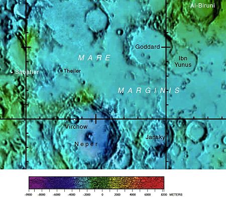
纳皮尔环形山的周边,月球正面区域详图[2]。

月球轨道器4号拍摄的斜视图

阿波罗10号拍摄的斜视图,面朝西北。

阿波罗11号拍摄的中央峰斜视图,面朝东北。
该陨坑西北和西北偏北分别毗邻小陨坑萨巴提和泰累尔、东北坐落了戈达德环形山和伊本·尤努斯环形山、央斯基环形山靠近它的东侧,它的西南侧与巴纳赫维奇环形山相接壤,而南面则是较小的塔基尼陨石坑,再往南则是史密斯海[3]。该陨坑中心月面坐标为8°46′N 84°35′E / 8.76°N 84.58°E / 8.76; 84.58,直径144.32公里[4],深度约2.96公里[1]。
纳皮尔环形山外观呈多边形状,已明显损毁,坑壁已被磨损挫低,南北二端几乎与周边地形等齐。陨坑内侧壁带有磨损的阶地状结构,坑壁最大高出周边地形1680米[1],内部容积约有23154公里3[1]。碗状的坑底已被玄武岩熔岩淹没,表面幽暗而平坦,靠西北坐落了直径约19公里的菲尔绍陨石坑,中心点附近矗立着一座由钙长石(A)和含85-90%斜长石的辉长-苏长-橄长斜长岩(GNTA1)和含80-85%斜长石的辉长-苏长-橄长斜长岩(GNTA2)组成的大圆形中央峰[5],其中南半部高1000米,而北半部高约2000米[6]。
卫星陨石坑
按惯例,最靠近纳皮尔环形山的卫星坑在月图上将在其中心点旁放置一字母来标注它们。

月球勘测轨道飞行器拍摄
| 纳皮尔 | 纬度 | 经度 | 直径 |
|---|---|---|---|
| D | 9.2° N | 80.8° E | 40 公里 |
| H | 10.4° N | 78.2° E | 9 公里 |
| Q | 8.0° N | 83.1° E | 12 公里 |
- 卫星坑"纳皮尔 A"已在1964年被国际天文学联合会更名为杜比亚戈环形山;
- 卫星坑"纳皮尔 G"已在1979年被国际天文学联合会更名为菲尔绍陨石坑;
- 卫星坑"纳皮尔 K"已在1973年被国际天文学联合会更名为塔基尼陨石坑。
图集

阿波罗11号拍摄的史密斯海(左)和纳皮尔环形山照片

参考文献
^ 1.01.11.21.3 Lunar Impact Crater Database
^ Map the reverse side of the moon.
^ Crater Neper on the map LAC-63.
^ Directory of the International Astronomical Union
^ Stefanie Tompkins and Carle M. Pieters (1999) Mineralogy of the lunar crust: Results from Clementine Meteoritics & Planetary Science, vol. 34, pp. 25-41 .
^ Naosuke Sekiguchi, 1972. Catalogue of Central Peaks and Floor Objects of the Lunar Craters on the Visible Hemisphere. University of Tokyo Press and University Park Press.
另请参阅
Gladstone-Millar, Lynne. Forgotten genius still burns bright. Edinburgh News. March 29, 2003 [2007-09-06]. (原始内容存档于2007-10-21).
.mw-parser-output .refbegin{font-size:90%;margin-bottom:0.5em}.mw-parser-output .refbegin-hanging-indents>ul{list-style-type:none;margin-left:0}.mw-parser-output .refbegin-hanging-indents>ul>li,.mw-parser-output .refbegin-hanging-indents>dl>dd{margin-left:0;padding-left:3.2em;text-indent:-3.2em;list-style:none}.mw-parser-output .refbegin-100{font-size:100%}
Andersson, L. E.; Whitaker, E. A. NASA Catalogue of Lunar Nomenclature. NASA RP-1097. 1982.
Blue, Jennifer. Gazetteer of Planetary Nomenclature. USGS. July 25, 2007 [2007-08-05].
Bussey, B.; Spudis, P. The Clementine Atlas of the Moon. New York: Cambridge University Press. 2004. ISBN 978-0-521-81528-4.
Cocks, Elijah E.; Cocks, Josiah C. Who's Who on the Moon: A Biographical Dictionary of Lunar Nomenclature. Tudor Publishers. 1995. ISBN 978-0-936389-27-1.
McDowell, Jonathan. Lunar Nomenclature. Jonathan's Space Report. July 15, 2007 [2007-10-24].
Menzel, D. H.; Minnaert, M.; Levin, B.; Dollfus, A.; Bell, B. Report on Lunar Nomenclature by the Working Group of Commission 17 of the IAU. Space Science Reviews. 1971, 12 (2): 136–186. Bibcode:1971SSRv...12..136M. doi:10.1007/BF00171763.
Moore, Patrick. On the Moon. Sterling Publishing Co. 2001. ISBN 978-0-304-35469-6.
Price, Fred W. The Moon Observer's Handbook. Cambridge University Press. 1988. ISBN 978-0-521-33500-3.
Rükl, Antonín. Atlas of the Moon. Kalmbach Books. 1990. ISBN 978-0-913135-17-4.
Webb, Rev. T. W. Celestial Objects for Common Telescopes 6th revised. Dover. 1962. ISBN 978-0-486-20917-3.
Whitaker, Ewen A. Mapping and Naming the Moon. Cambridge University Press. 1999. ISBN 978-0-521-62248-6.
Wlasuk, Peter T. Observing the Moon. Springer. 2000. ISBN 978-1-85233-193-1.
外部链接
- 月球数码摄影地图.
- 阿波罗8号、10号、11号、14号、15号、16号和17号拍摄的纳皮尔环形山照片.
- 纳皮尔环形山周边地形图.
- 深邃、年轻和幽暗.
- 旧图片、新视角.
- 维基月球在线解说-纳皮尔环形山.
- Andersson, L.E., 和 E.A. Whitaker, 美国宇航局参考出版物1097, 1982年10月.
Comments
Post a Comment