 Mixing
Pass Christian, Mississippi
Pass Christian, Mississippi | ||
|---|---|---|
City | ||
| ||
 Location of Pass Christian, Mississippi | ||
 Pass Christian, Mississippi Location in the United States | ||
| Coordinates: 30°19′28″N 89°14′50″W / 30.32444°N 89.24722°W / 30.32444; -89.24722Coordinates: 30°19′28″N 89°14′50″W / 30.32444°N 89.24722°W / 30.32444; -89.24722 | ||
| Country | United States | |
| State | Mississippi | |
| County | Harrison | |
| Government | ||
| • Mayor | Leo McDermott | |
| Area | ||
| • Total | 15.3 sq mi (39.6 km2) | |
| • Land | 8.4 sq mi (21.8 km2) | |
| • Water | 6.9 sq mi (17.8 km2) | |
| Elevation | 13 ft (4 m) | |
| Population (2010) | ||
| • Total | 4,613 | |
| • Estimate (2016)[1] | 5,701 | |
| • Density | 300/sq mi (120/km2) | |
| Time zone | UTC−6 (Central (CST)) | |
| • Summer (DST) | UTC−5 (CDT) | |
| ZIP code | 39571 | |
| Area code(s) | 228 | |
| FIPS code | 28-55400 | |
GNIS feature ID | 0675482 | |
| Website | www.pass-christian.com | |

Pass Christian (/ˌpæs krɪstʃiˈæn/),[citation needed] nicknamed The Pass, is a city in Harrison County, Mississippi, United States. It is part of the Gulfport–Biloxi Metropolitan Statistical Area. The population was 4,613 at the 2010 census.[2]
Contents
1 History
1.1 Pre-European history
1.2 Spanish explorers
1.3 French explorers
1.4 The Widow Asmard
1.5 Civil War
1.6 Hurricanes and disaster management
1.6.1 Hurricane Camille
1.6.2 Hurricane Katrina
2 Geography
2.1 Pass Christian harbor
3 Demographics
4 Economy
4.1 Manufacturing
4.2 Seafood processing
5 Tourism
5.1 Middlegate Japanese Gardens
5.2 Sherman Castle
6 Government
6.1 Naval Construction Battalion Center
7 Education
8 Notable people
9 See also
10 References
11 Further reading
12 External links
History
Pre-European history
The exact date when Native Americans first arrived in the Gulf Coast area is not known, but artifacts have been found suggesting that humans have inhabited the area for many thousands of years.
Indian mounds can be found throughout the Gulf coast region of southern Mississippi, but many have been destroyed by artifact hunters, farmers, developers, and flooding. A 1768 English map shows one large mound existed on the shore near to Market Street. Others existed at Bayou Portage and the Shelly Plantation on the shore north of the Bay of St. Louis near DeLisle. The mounds and middens in the area containing arrowheads, pottery, and human skeletons were pilfered by amateur archaeologists over the years and many of the items recovered are in private collections. At the border of Pass Christian and Long Beach near where White Harbor Road meets Hwy. 90 there once existed an Indian village, whose inhabitants were referred to by locals as "The Pitcher Point Indians". The approximate location of the Indian Village is just a few hundred yards east of White Harbor Road. There are no ruins at this location but the beach in this area has produced many arrowheads and pottery shards over the years.
Spanish explorers
It is likely that Pitcher Point is the location where survivors of the 1528 Álvar Núñez Cabeza de Vaca Narváez expedition landed naked and starving among a people called the Carnones. This story was told to DeVaca by friendly Indians who stated that, "the natives had killed the Spanish who were so feeble that they could not defend themselves."
French explorers
Pass Christian was discovered by French-Canadian explorers in 1699, shortly after the first French colony was established in Biloxi. In June 1699, while sounding the channel at the Pass Christian peninsula, the French named that channel Passe aux Huîtres for the many oysters they found there. Pass Christian was named for a nearby deepwater pass, which in turn was named for Nicholas Christian L'Adnier, who lived on nearby Cat Island beginning in 1746.[3]
The Widow Asmard
In 1781 all of Pass Christian peninsula was owned by Julia de la Brosse (Widow Asmard). Upon her death in 1799, Widow Asmard deeded 800 arpents – the entire downtown Pass Christian – to Charles Asmar, a free person of color,[4] who upon his death left the property to his heirs. Pass Christian was officially chartered as a town in 1848.[5]
Civil War
The town was a famous resort prior to the American Civil War. It was a favorite location for the beach and summer homes of the wealthy of New Orleans, who built a row of historic mansions along the shoreline, where Scenic Drive was one of the country's notable historic districts.[citation needed] The Southern Yacht Club, established in 1849, was the first yacht club in the South and the second in the United States, and was originally located in Pass Christian before moving to New Orleans in 1857.[6] The Pass Christian Yacht Club was itself founded in the mid 20th century.
Hurricanes and disaster management
Hurricane Camille
Pass Christian was in the path of two of the most intense hurricanes ever to hit the United States--Hurricane Camille on August 17, 1969, and Hurricane Katrina on August 29, 2005. Each hurricane caused the near total destruction of the city.
Hurricane Camille destroyed the Richelieu Apartments killing eight people who had chosen to ride the storm out. Early Sunday, August 17, the storm was southeast of New Orleans by 200 miles. A Hurricane Warning was then announced for the entire Mississippi Coast. Evacuation was advised but some of the occupants of the Richelieu apartments ignored the warning. The hurricane party depicted in Hurricane, a 74 minute TV movie featuring some notable stars, includes original footage of Camille.
Hurricane Katrina
On August 29, 2005, Pass Christian was almost completely destroyed by Hurricane Katrina. Of the approximately 8,000 homes in Pass Christian, all but 500 were damaged or destroyed. In spite of the fact that the beachfront Scenic Drive follows the crest of a small bluff, affording it some elevation, most of the historic mansions along the road were severely damaged, and many were completely destroyed, including the superbly restored Greek Revival mansion "Union Quarters" described in the National Register of Historic Places as having been built in 1855. A cast iron fence fronted the property enclosing a Magnolia Historical Marker which was dedicated in 1960. It read, "Union officers were temporarily quartered here during the invasion of Pass Christian."
Hurricane Katrina totally destroyed the local public library. It was rebuilt.[7] Thirteen members of the city's police department retreated to the library after the police station became unsafe and water from the Gulf of Mexico began to pour in.
The library was immediately north of City Hall across a small parking lot but was at a lower elevation. When the water crested the elevation of City Hall, the police cars in the parking lot began to float and were carried around the parking lot by the current. One car struck the south side doors, causing them to implode, and the Gulf of Mexico driven by Katrina's powerful winds rushed into the building. With no way to fight against the current they were trapped inside a concrete box that was rapidly filling with water. Knowing that they had to escape they attempted to shoot the glass out of the north side of the building. This was unsuccessful, as the bullets ricocheted off the glass. The laminated glass proved impervious to the .45 caliber rounds of the police-issue handguns. The force of the water entering the building after the southern wall was destroyed by the car was far too strong to swim against. The only way out was with the current. Police Chief John Dubbisson swam to the rear doors that had to be opened where he successfully touched the push bar. He then grabbed a railing before the storm surge could carry him off. All that were inside the library made it outside and rode out the rest of the storm on the roof.[8][9]
The storm surge from Hurricane Katrina that hit Pass Christian was estimated at 8.5 m (27.8 ft),[10] which is the US record high,[11] leveling Pass Christian up to half a mile inland from the shore; estimation of highest storm surges was complicated because high-water markers were also destroyed. Highway 90 along the beach was damaged, and the bridge over the Bay of St. Louis was thrown completely apart, not being reopened until a new bridge was partially completed in May 2007. (Connection was temporarily replaced by a ferry service.) Sewage contamination rendered the local water supply unusable, as some samples tested positive for more than 250 bacteria and parasites. By late September 2005, access was restricted south of the railroad tracks (about four blocks inland) without proper credentials, as crews continued to search for victims and clear debris. In early 2007, although rebuilding was underway in much of the city, a large portion of empty, deserted homes and other structures remain. Many residents were still living in FEMA trailers, and out-of-state volunteers were still needed for the rebuilding effort.
Geography

Pass Christian, Mississippi (map center) is east of Bay St. Louis, along the Gulf of Mexico.
According to the United States Census Bureau, the city has a total area of 15.3 square miles (40 km2), of which 8.4 square miles (22 km2) is land and 6.9 square miles (18 km2) (44.97%) is water.
Geographically, the town of Pass Christian located on the Mississippi Sound, and is situated on a peninsula, with water on three sides: the Gulf of Mexico to the south, the Bay of St. Louis to the west and a long stretch of bayou to the north.
The unincorporated area north of the bayou, known as DeLisle, shares a zip code with Pass Christian, but is not within the city limits. DeLisle was formerly known as Wolf Town or Wolftown.
Pass Christian harbor
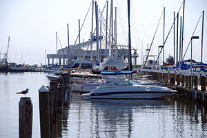
Pass Christian Harbor
The Municipal Harbor was formalized in 1956 with the creation of a Harbor Commission. In 1958, an 11-foot high, 350-foot long, concrete, breakwater wall was constructed in the sound by the T.L. James Company. There are only two such concrete harbor walls in the world, with the other in Japan. Almost 1000 linear feet of public fishing is permitted on the two breakwalls. The harbor consists of seven piers, four assigned for pleasure craft and three for commercial vessels. Before it was destroyed by waves from Hurricane Katrina there were 346 slips ranging in berth sizes from 31-feet to 84-feet, in addition to a skiff-pier providing 20 tie-ups. Water, electricity, showers, restrooms, and a bait and fuel station and a vessel pump-out station were available, all overseen from the two-story Harbor Master office.[citation needed]
Demographics
| Historical population | |||
|---|---|---|---|
| Census | Pop. | %± | |
| 1850 | 790 | — | |
| 1870 | 1,951 | — | |
| 1880 | 1,410 | −27.7% | |
| 1890 | 1,705 | 20.9% | |
| 1900 | 2,028 | 18.9% | |
| 1910 | 2,458 | 21.2% | |
| 1920 | 2,357 | −4.1% | |
| 1930 | 3,004 | 27.5% | |
| 1940 | 3,338 | 11.1% | |
| 1950 | 3,383 | 1.3% | |
| 1960 | 3,881 | 14.7% | |
| 1970 | 2,979 | −23.2% | |
| 1980 | 5,014 | 68.3% | |
| 1990 | 5,557 | 10.8% | |
| 2000 | 6,579 | 18.4% | |
| 2010 | 4,613 | −29.9% | |
| Est. 2016 | 5,701 | [1] | 23.6% |
| U.S. Decennial Census[12] | |||
As of the census[13] of 2000, there were 6,579 people, 2,687 households, and 1,797 families residing in the city. The population density was 781.2 people per square mile (301.7/km²). There were 3,351 housing units at an average density of 397.9 per square mile (153.7/km²). The racial makeup of the city was 65.91% White, 28.17% African American, 0.62% Native American, 3.48% Asian (almost all Vietnamese American), 0.03% Pacific Islander, 0.62% from other races, and 1.17% from two or more races. Hispanic or Latino of any race were 1.75% of the population.
There were 2,687 households out of which 27.3% had children under the age of 18 living with them, 46.6% were married couples living together, 16.0% had a female householder with no husband present, and 33.1% were non-families. 27.4% of all households were made up of individuals and 11.3% had someone living alone who was 65 years of age or older. The average household size was 2.38 and the average family size was 2.88.
In the city, the population was spread out with 23.4% under the age of 18, 6.9% from 18 to 24, 25.3% from 25 to 44, 25.2% from 45 to 64, and 19.1% who were 65 years of age or older. The median age was 41 years. For every 100 females, there were 86.9 males. For every 100 females age 18 and over, there were 84.6 males.
The median income for a household in the city was $40,743, and the median income for a family was $46,232. Males had a median income of $35,352 versus $22,195 for females. The per capita income for the city was $26,008. About 8.2% of families and 10.8% of the population were below the poverty line, including 18.0% of those under age 18 and 6.2% of those age 65 or over.
Economy
Manufacturing
The Du Pont White Pigment and Mineral Products Plant – now known as the Chemours DeLisle Plant – is located just south of I-10 in DeLisle. The plant is one of the world's largest producers of titanium dioxide and has been in operation since 1979. The town of Pass Christian is near the plant, directly across the Bay of St. Louis. Some community members also expressed concerns that chemical releases, as reported on EPA's Toxic Release Inventory, from the DuPont plant could have contaminated the community's water and air.[14] DuPont DeLisle's titanium dioxide plant reported the third highest amount of dioxin-like compounds in EPA's Toxic Release Inventory (TRI). In 2005, the Hurricane Katrina storm surge flooded significant portions of the plant. Unlike other aquatic organisms, blue crabs do not have the ability to metabolize quickly certain dioxin-like compounds Polychlorinated dibenzofurans that predominate in the coke and ore solids waste stream of the plant.
Seafood processing
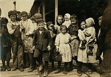
Children employed as oyster shuckers at Pass Packing Company, 1911. Photo by Lewis Hine.
Seafood production in the region has been severely impacted by large scale fish die-offs. The Deepwater Horizon oil spill, which occurred in the spring and summer of 2010—along with the presence of toxic sediments stirred up by Hurricane Katrina and record amounts of fresh water diverted into the Bonnet Carre Spillway in Louisiana—have brought seafood production to a standstill. Offshore oyster beds were hit especially hard. Field crews have reported a 50 percent to 65 percent mortality rate in some areas. An even greater mortality rate of 90 percent to 95 percent has been seen in other oyster beds.
Tourism
Middlegate Japanese Gardens
Between 1923 and 1929 New Orleans residents Rudolf Hecht and Lynne Watkins Hecht developed Middlegate Japanese Gardens at their summer home in Pass Christian, Mississippi.[15]
The Hechts built Middlegate Japanese gardens to perpetuate their pleasant memories of their
travels in Japan. The gardens are listed on the National Register of Historic Places. Since 1923 when the Hechts established them, Middlegate Japanese Gardens have been private, residential gardens.[16] The gardens were extensively damaged by Hurricane Katrina in 2005. The Smithsonian Institution has included the gardens on their Collection Search Center website.[17]
Sherman Castle
James M. Sherman began construction of Sherman Castle in 1921. The building is constructed of concrete blocks and steel and contained a plaque which read "God is my Sculptor".[18]
Government
Pass Christian's government is a mayor–council government system. The current mayor, Leo "Chipper" McDermott, was elected in a special election in 2006, following the resignation of the previous mayor, and then re-elected for a full term in 2009.
Current Board of Aldermen
- WARD I Buddy Clark
- WARD II Earl Washington
- WARD III Anthony Hall
- WARD IV Victor Pickich
- ALDERMAN AT LARGE Kenny Torgeson
Naval Construction Battalion Center Gulfport, Mississippi, launched Seabees on Sept. 9 to neighboring communities throughout Harrison and Stone counties, including Pass Christian, to assist its citizens with disaster recovery in the wake of Hurricane Katrina. In a measure to improve health, sanitation and morale, the Seabees cleared approximately three miles of railroad track for a temporary sewer line, they set up a laundry unit and installed a nine-head shower unit for the firefighters and volunteers. They also built temporary housing to house 1,000 people rendered homeless by the impact of Hurricane Katrina. 250 Seabees from detachments across the United States gathered behind the city's War Memorial Park, where they constructed a temporary police department headquarters and other municipal offices. This was not the first time that Seabees have answered the call to duty in Pass Christian. The naval construction teams performed a similar feat after Hurricane Camille struck the town hard in 1969.
Education
The Pass Christian School District operates the schools in the city, and in the inland, unincorporated areas around and to the north of DeLisle. The Pass Christian Middle School (formerly the Pass Christian High School) on the corner of 2nd Street and Church Street was destroyed by Hurricane Katrina. A monument proclaiming that the school had withstood Hurricane Camille was left standing. The new Pass Christian High School, which opened in 2001, was flooded almost to the second level, but was renovated and re-opened in October 2006. The Pass Christian Elementary School, across the street from the high school, was also flooded and was torn down because of mold concerns. Delisle Elementary was the only school left standing, and became a temporary grounds for all of the students of the Pass Christian School District, housed either in temporary trailer classrooms or in the elementary school, sharing cafeteria and gymnasium facilities with the school.
A new educational complex housing Pass Christian Middle School and Pass Christian Elementary School is the $32 million Pass Christian Center of Excellence. It includes a day care center and an attached Boys & Girls Club,[19] on the north side of campus. It opened in 2010. As of 2011, Delisle Elementary School has been torn down and is under reconstruction.[citation needed]
Pass Christian High School is a Blue Ribbon school.[20]
The parochial elementary and middle school of St. Paul's Roman Catholic church was destroyed by Katrina, and the school was merged with the neighboring Long Beach parochial school to form St. Vincent de Paul School. Coast Episcopal High School is a parochial high school in Pass Christian.
Notable people
Bidwell Adam, Gulfport lawyer and Democratic politician, Lieutenant Governor of Mississippi from 1928 to 1932; reared in Pass Christian and graduate of Pass Christian High School[21]
Phelan Beale, original owner of Grey Gardens
Clyde F. Bel, Jr., businessman from New Orleans and state representative for Orleans Parish, 1964–1972 and 1975–1980; spent much of his later life in Pass Christian[22]
Edward Price Bell, Chicago journalist
Captain John Handy, jazz musician
Jimmy Johnson, cartoonist and creator of the syndicated newspaper comic strip Arlo and Janis
Margaret Loesch, television executive and producer, formerly founding CEO of Fox Kids Networks and the US Hallmark Channel, currently CEO of The Hub, a TV network
Oliver Randolph, African American lawyer and politician
Robin Roberts, ABC News' Good Morning America anchor who returned home to provide emotional coverage of the aftermath of Hurricane Katrina
Ben C. Toledano, lawyer and author, Pass Christian resident since 1991; politician in New Orleans prior to 1973[23]
Jesmyn Ward, novelist, winner of the 2011 National Book Award for Fiction; born in DeLisle
See also
- J.W. Randolph School (Pass Christian, Mississippi)
References
^ ab "Population and Housing Unit Estimates". Retrieved June 9, 2017..mw-parser-output cite.citation{font-style:inherit}.mw-parser-output q{quotes:"""""""'""'"}.mw-parser-output code.cs1-code{color:inherit;background:inherit;border:inherit;padding:inherit}.mw-parser-output .cs1-lock-free a{background:url("//upload.wikimedia.org/wikipedia/commons/thumb/6/65/Lock-green.svg/9px-Lock-green.svg.png")no-repeat;background-position:right .1em center}.mw-parser-output .cs1-lock-limited a,.mw-parser-output .cs1-lock-registration a{background:url("//upload.wikimedia.org/wikipedia/commons/thumb/d/d6/Lock-gray-alt-2.svg/9px-Lock-gray-alt-2.svg.png")no-repeat;background-position:right .1em center}.mw-parser-output .cs1-lock-subscription a{background:url("//upload.wikimedia.org/wikipedia/commons/thumb/a/aa/Lock-red-alt-2.svg/9px-Lock-red-alt-2.svg.png")no-repeat;background-position:right .1em center}.mw-parser-output .cs1-subscription,.mw-parser-output .cs1-registration{color:#555}.mw-parser-output .cs1-subscription span,.mw-parser-output .cs1-registration span{border-bottom:1px dotted;cursor:help}.mw-parser-output .cs1-hidden-error{display:none;font-size:100%}.mw-parser-output .cs1-visible-error{font-size:100%}.mw-parser-output .cs1-subscription,.mw-parser-output .cs1-registration,.mw-parser-output .cs1-format{font-size:95%}.mw-parser-output .cs1-kern-left,.mw-parser-output .cs1-kern-wl-left{padding-left:0.2em}.mw-parser-output .cs1-kern-right,.mw-parser-output .cs1-kern-wl-right{padding-right:0.2em}
^ "Profile of General Population and Housing Characteristics: 2010 Demographic Profile Data (DP-1): Pass Christian city, Mississippi". U.S. Census Bureau, American Factfinder. Retrieved May 16, 2012.
^ [1] Archived July 18, 2011, at the Wayback Machine.
^ "Details for in Petition ASMAR, Charles ([Charlo])11086001 - Race and Slavery Petitions Project". Library.uncg.edu. Retrieved 2017-05-02.
^ "Pass Time Line". History.passchristian.net. Retrieved 2017-05-02.
^ "Southern Yacht Club". International Council of Yacht Clubs. Retrieved July 1, 2014.
^ "Hurricane Katrina Related Damages to Public Libraries in Mississippi" (September 2005), Mississippi Library Commission, web:ALA-Katrina. Archived October 31, 2007, at the Wayback Machine.
^ David Kithcart. "A Daring Escape from Katrina's Flood Waters". The 700 Club. Christian Broadcasting Network. Retrieved October 23, 2014.
^ Savidge, Martin (2005-11-03). "Shootout at Pass Christian". The Daily Nightly. MSNBC. Retrieved 2014-10-23.
^ Knabb, Richard D; Rhome, Jamie R.; Brown, Daniel P (2005-12-20). "Tropical Cyclone Report: Hurricane Katrina: 23–30 August 2005" (PDF). National Hurricane Center. Retrieved 2008-10-11.
^ "U.S. storm surge records | Weather Underground". Wunderground.com. Retrieved 2017-05-02.
^ "Census of Population and Housing". Census.gov. Retrieved June 4, 2015.
^ "American FactFinder". United States Census Bureau. Retrieved 2008-01-31.
^ "Health Consultation Dupont DeLisle Plant (a/k/a DuPont E I De Nemours and Company, Incorporated) Pass Christian, Harrison County, Mississippi" (PDF). U. S. Department of Health and Human Services.
 This article incorporates text from this source, which is in the public domain.
^ Margaret Anne Legett, Middlegate Japanese Gardens: Preservation, Private Property, and Public Memory. Hattiesburg: University of Southern Mississippi, 1964.
^ Crawford, Kelly (2011-08-23). "Smithsonian Collections Blog: Middlegate Japanese Gardens: A Garden Gone, but not Forgotten". Si-siris.blogspot.com. Retrieved 2017-05-02.
^ [2]
^ "Sherman's Requiem". Sherman.passchristian.net. Retrieved 2017-05-02.
^ Samuels, Christina A. "Region's Schools Turn Storm's Havoc Into Transformation." EducationWeek. August 25, 2010. Retrieved August 4, 2012.
^ "Archived copy". Archived from the original on 2011-08-07. Retrieved 2011-03-11.CS1 maint: Archived copy as title (link)
^ John H. Lang, History of Harrison County, Mississippi Dixie Press, 1935, p. 135
^ "Clyde F. Bel, Jr". The New Orleans Advocate. September 9, 2014. Retrieved May 22, 2015.
^ "Toledano, Ben C." ourcampaigns.com. Retrieved June 8, 2014.
Further reading
- Legett, Margaret Ann. Middlegate Japanese Gardens: Preservation, Private Property and Public Memory. 2004.
External links
| Wikimedia Commons has media related to Pass Christian, Mississippi. |
- Official website
Municipalities and communities of Harrison County, Mississippi, United States | ||
|---|---|---|
County seats: Biloxi and Gulfport | ||
| Cities |
|  |
| CDPs |
| |
| Unincorporated communities |
| |
Jackson (capital) | ||
| Topics |
|  Seal of Mississippi |
| Society |
| |
| Regions |
| |
| Metros |
| |
| Larger cities |
| |
| Smaller cities |
| |
| Counties |
| |


Comments
Post a Comment