 Mixing
Ceduna, South Australia
Ceduna South Australia | |||||||||
|---|---|---|---|---|---|---|---|---|---|
 Poynton Street, the main street of Ceduna | |||||||||
 Ceduna | |||||||||
| Coordinates | 32°07′0″S 133°40′0″E / 32.11667°S 133.66667°E / -32.11667; 133.66667Coordinates: 32°07′0″S 133°40′0″E / 32.11667°S 133.66667°E / -32.11667; 133.66667 | ||||||||
| Population | 2,289 (2011 census)[1] | ||||||||
| Established | 1898 | ||||||||
| Postcode(s) | 5690[2] | ||||||||
| Location |
| ||||||||
| LGA(s) | District Council of Ceduna | ||||||||
| State electorate(s) | Flinders | ||||||||
| Federal Division(s) | Grey | ||||||||
| |||||||||
Ceduna is a town in South Australia located on the shores of Murat Bay on the west coast of Eyre Peninsula. It lies west of the junction of the Flinders and Eyre Highways around 786 km northwest of the capital Adelaide. The port town/suburb of Thevenard lies 3 km to the west on Cape Thevenard. It is in the District Council of Ceduna, the federal Division of Grey, and the state electoral district of Flinders.
The name Ceduna is a corruption of the local Aboriginal Wirangu word Chedoona and is said to mean a place to sit down and rest.[3]
The town has played an important but minor role in Australia's overall development due to it being a fishing port and a railway hub.
Contents
1 History
2 Description
2.1 Demographics
2.2 Education
2.3 Economic activity
2.4 Scientific research
2.5 Cultural festivals
2.6 In media
2.7 Tourism
3 Environment
3.1 Climate
4 Notable people
5 See also
6 References
7 External links
History

Murat Bay in Ceduna looking over to Thevenard during Oysterfest 2012
Ceduna is on land that was part of the traditional home of the Wirangu people.
Matthew Flinders, on his voyage in the Investigator, anchored in Fowlers Bay on 28 January 1802. He went on to explore the coast and named Denial Bay, Smoky Bay and the islands of Nuyts Archipelago. He was disappointed to find no river and gave the name Denial Bay because they did not find fresh water.[citation needed]
French expedition leader Nicolas Baudin discovered Murat Bay after meeting with Flinders and named it after Joachim Murat. He also named the point of Thevenard after the Admiral and Minister of Marine Antoine-Jean-Marie Thevenard, and Decres Bay after Denis Decres, duke of the First French Empire.
The first European exploration of the hinterland was during August–September 1839 by John Hill and Samuel Stephens, using the chartered brig Rapid as a base. Hill reported to Governor Gawler that although the bay was 'valuable', the hinterland was 'waterless', thereby stalling European interest.[4][5]
There was a whaling station on nearby St Peter Island during the 1850s before settlement.
The Commissioner of Crown Lands, faced with widespread agitation to open West Coast lands for agricultural settlement, invited three farmers in July 1887 to inspect the lands between Streaky Bay and Western Australia. They were optimistic about the area and recommended that the necessary surveys be started at once. In 1889 the Government in Adelaide formalised the Far West with survey lines.
In June 1901, the town of Ceduna was proclaimed. For many years, locals called the township Murat Bay and it was not until the railways came and called the siding Ceduna in 1915 that locals adopted the name. The Ceduna Jetty was built in 1902.
The Tod Water pipeline was officially opened by Mr M McIntosh, Commissioner of Public Works, June 1928.
Ceduna was the site of a major satellite telecommunications facility operated by the Overseas Telecommunications Commission. It was a major employer in the town until made redundant by technological change. It was built in 1969 and by 1984 almost half of Australia's International telecommunication traffic passed through Ceduna's Earth Station.[6]
On 4 December 2002, Ceduna received international attention when the path of totality of a solar eclipse passed directly over the town. Though the day had at times been partly cloudy, and although mere kilometres away in Thevenard the view was still clouded over, the southwestern sky where the Sun and Moon were located was clear from Ceduna itself at the time of the total solar eclipse, late in the afternoon.[citation needed]
In the 2007/2008 State Budget, Premier Mike Rann (who had opened the new Ceduna TAFE campus in the early 1990s) announced a commitment of $36 million for Stage 1 of the Ceduna Hospital Redevelopment. It was opened in 2011.[7]
In February 2010 Premier Rann opened the world's largest mineral sands mine, operated by Iluka Resources. The $390 million mine is located 200 km north west of Ceduna.[8]
Description
The town is the last major settlement before crossing the Nullarbor Plain from east to west. It is set on Murat Bay and the sandy coves, sheltered bays and offshore islands of the bay make it a popular base for a beach holiday. The foreshore at Ceduna is lined with Norfolk Island pine trees. There is a jetty for walking, fishing and small boats.
Demographics
In the 2011 census the Ceduna urban area had a population of 2,289,[1] and the Ceduna council area a population of 3,480.[9][10]
Ceduna has a number of Indigenous homelands situated within 20–30 minutes of the town. These are groupings of Indigenous families who have chosen to live together. The council area has the highest percentage of Aboriginal people of all local government areas in South Australia, with the population currently standing at 24.8% (911) of the population.[10] A number of Aboriginal communities in adjacent unincorporated areas rely on the available services in Ceduna and use the town as a base for a variety of reasons.[10]
Very few of the indigenous inhabitants of Ceduna continue to speak the Wirangu language. As the regional service town, Ceduna attracts indigenous people from many language groups in western South Australia. The Far West Languages Centre (FWLC) was established in 2006 to maintain three local Endangered languages including Wirangu, along with Mirning and Kokatha.[11]
Education
The two schools in Ceduna are Crossways Lutheran School and Ceduna Area School (CAS).[12] Crossways has around 150 students from Reception to Year 10, approximately 80% of whom are Indigenous. CAS has approximately 600 students, from Reception to Year 12, with approximately 25% of Indigenous students.
Economic activity
Iluka Resources developed a mineral sands mine at Jacinth- Ambrosia which relies on Ceduna as a service town.
A major residential development called Ceduna Waters was developed by Carramatta Holdings, a significant South Australian property developer in early 2010. Ceduna Waters is approximately 3 km from the town centre and is approximately 30% occupied as of May 2013.[citation needed]
Prospectively, the development was projected to result in the growth of the population of Ceduna by over 10%.[citation needed] The development will allow for the provision of additional residential accommodation in Ceduna to meet the needs of workers at the Jacinth-Ambrosia mine.[citation needed]
The Thevenard port of Ceduna is a high-frequency deep sea port which exports grain, salt, mineral sand and gypsum, all which are found within the local region.
Aquaculture remains a major industry in Ceduna with pacific oyster growing a key activity in the region. In recent years deep sea fishing and tuna fishing have attracted industries from Port Lincoln to the region.[13]
In 2012, BP commenced the ability to seek approval for oil drilling off the nearby Great Australian Bight. BP is currently investing $20 million into a study of the regions ecosystem and social and economic potential.[14]
Scientific research

Former OTC dish, now used for radio astronomy
Ceduna has a radio telescope that is integrated into the CSIRO radio telescope network. Telstra donated the dish to the University of Tasmania in 1996 for use as a radio astronomy observatory. It is still in active use.[15]
Ceduna is also a hub for research on southern bluefin tuna.
Cultural festivals
Ceduna's annual Oysterfest is a major attraction held on the South Australia Labour Day long weekend. It was established in 1991. Attracting over 6000 people,[16] it celebrates the oyster industry in the clean waters of SA's far-west coast, with a wide variety of activities, including a gala dinner, celebrity chefs, live concerts, children's amusements and a street parade. The finale is marked by a fireworks display.
In media
Ceduna was used as a major filming location for the 1997 film Kiss or Kill starring Frances O'Connor. It was a key setting for the factual drama Black and White although the township was not used as a filming location. In 2012 Ceduna was featured in the independent feature film Nullarbor Nymph which achieved cult status around the country.
The Cashless Welfare Card began a trial there in March 2016, attracting media attention.[17]
Tourism
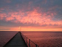
Ceduna, South Australia jetty in autumn
Ceduna is known as the gateway to the Nullarbor Plain and being on the National Highway its traffic flow is over 240,000 vehicles a year.[citation needed] The township has five caravan parks, four motels and one accommodating hotel.[citation needed] The tourism industry is driven by the nearby conservation parks, beaches and fishing opportunities.
Environment
Climate
Ceduna has a semi-arid climate with hot, dry summers and cool, slightly wetter winters[18] July is the wettest month. The average yearly precipitation is just under 300mm at the coast and diminishes northward into the interior, becoming increasingly arid.[19]Goyder's Line, which demarcates the edge of the area where rainfall is generally sufficient to support agriculture, starts near Ceduna.[20]
| Climate data for Ceduna | |||||||||||||
|---|---|---|---|---|---|---|---|---|---|---|---|---|---|
| Month | Jan | Feb | Mar | Apr | May | Jun | Jul | Aug | Sep | Oct | Nov | Dec | Year |
| Record high °C (°F) | 47.9 (118.2) | 47.3 (117.1) | 45.8 (114.4) | 40.8 (105.4) | 34.0 (93.2) | 29.8 (85.6) | 32.6 (90.7) | 33.6 (92.5) | 39.7 (103.5) | 43.5 (110.3) | 45.9 (114.6) | 47.3 (117.1) | 47.9 (118.2) |
| Average high °C (°F) | 28.5 (83.3) | 28.2 (82.8) | 26.7 (80.1) | 24.2 (75.6) | 20.9 (69.6) | 18.2 (64.8) | 17.4 (63.3) | 18.7 (65.7) | 21.4 (70.5) | 23.8 (74.8) | 25.9 (78.6) | 27.2 (81) | 23.4 (74.1) |
| Average low °C (°F) | 15.1 (59.2) | 15.0 (59) | 13.1 (55.6) | 10.7 (51.3) | 8.5 (47.3) | 6.4 (43.5) | 5.7 (42.3) | 6.2 (43.2) | 7.8 (46) | 9.9 (49.8) | 12.2 (54) | 14.0 (57.2) | 10.4 (50.7) |
| Record low °C (°F) | 5.0 (41) | 4.9 (40.8) | 1.3 (34.3) | −0.3 (31.5) | −3.2 (26.2) | −4.7 (23.5) | −4.3 (24.3) | −3.3 (26.1) | −1.2 (29.8) | −0.4 (31.3) | 1.6 (34.9) | 3.4 (38.1) | −4.7 (23.5) |
| Average precipitation mm (inches) | 11.6 (0.46) | 12.9 (0.51) | 16.4 (0.65) | 19.5 (0.77) | 32.3 (1.27) | 35.1 (1.38) | 39.9 (1.57) | 34.8 (1.37) | 27.9 (1.1) | 25.4 (1) | 19.9 (0.78) | 20.8 (0.82) | 296.8 (11.69) |
| Average relative humidity (%) | 45 | 46 | 47 | 47 | 50 | 53 | 54 | 50 | 47 | 44 | 43 | 45 | 48 |
| Source: [21] | |||||||||||||
Notable people
- Jenny Borlase (née Kennett), former netballer, born in Ceduna[citation needed]
- Krista Eleftheriou, journalist and former television presenter, raised in Ceduna[citation needed]
Kym LeBois, professional AFL footballer playing for Carlton Football Club
Scott Lycett, professional AFL footballer playing for West Coast Eagles
Jodi Martin, singer/songwriter, born and raised in Ceduna
Terry Milera, professional AFL footballer playing for St Kilda Football Club[citation needed]
Tyson Stengle, professional AFL footballer playing for Richmond Football Club
Chris Sperou, aerobatic pilot, born in Ceduna in 1938
See also
- Ceduna Airport
- Point Bell Conservation Park
References
^ ab Australian Bureau of Statistics (31 October 2012). "Ceduna (Urban Centre/Locality)". 2011 Census QuickStats. Retrieved 3 May 2013..mw-parser-output cite.citation{font-style:inherit}.mw-parser-output q{quotes:"""""""'""'"}.mw-parser-output code.cs1-code{color:inherit;background:inherit;border:inherit;padding:inherit}.mw-parser-output .cs1-lock-free a{background:url("//upload.wikimedia.org/wikipedia/commons/thumb/6/65/Lock-green.svg/9px-Lock-green.svg.png")no-repeat;background-position:right .1em center}.mw-parser-output .cs1-lock-limited a,.mw-parser-output .cs1-lock-registration a{background:url("//upload.wikimedia.org/wikipedia/commons/thumb/d/d6/Lock-gray-alt-2.svg/9px-Lock-gray-alt-2.svg.png")no-repeat;background-position:right .1em center}.mw-parser-output .cs1-lock-subscription a{background:url("//upload.wikimedia.org/wikipedia/commons/thumb/a/aa/Lock-red-alt-2.svg/9px-Lock-red-alt-2.svg.png")no-repeat;background-position:right .1em center}.mw-parser-output .cs1-subscription,.mw-parser-output .cs1-registration{color:#555}.mw-parser-output .cs1-subscription span,.mw-parser-output .cs1-registration span{border-bottom:1px dotted;cursor:help}.mw-parser-output .cs1-hidden-error{display:none;font-size:100%}.mw-parser-output .cs1-visible-error{font-size:100%}.mw-parser-output .cs1-subscription,.mw-parser-output .cs1-registration,.mw-parser-output .cs1-format{font-size:95%}.mw-parser-output .cs1-kern-left,.mw-parser-output .cs1-kern-wl-left{padding-left:0.2em}.mw-parser-output .cs1-kern-right,.mw-parser-output .cs1-kern-wl-right{padding-right:0.2em}

^ Ceduna Postcode Archived 30 December 2012 at Archive.is Australia Post
^ "Ceduna, SA". Aussie Towns. Retrieved 17 May 2017.
^ Register, 26 October 1839, pp.5 and 17.
^ Secondary Towns Association, formed for the purchasing of one or more ... – Secondary Towns Association, London – Google Books. Books.google.com.au. Retrieved 23 November 2013.
^ Ceduna Business & Tourism Association > Places of interest > Ceduna OTC Earth Station Archived 20 January 2017 at the Wayback Machine. Accessed 25 Sept 2015.
^ http://www.get Archived 6 August 2013 at the Wayback Machine. farming.com.au, 29 March 2011 "More investment in country health."
^ Australian Mining 10 February 2010
^ Australian Bureau of Statistics (31 October 2012). "Ceduna (DC)". 2011 Census QuickStats. Retrieved 3 May 2013.
^ abc "Archived copy". Archived from the original on 12 April 2010. Retrieved 27 March 2010.CS1 maint: Archived copy as title (link)
^ "Far West Languages Centre". Far West Languages Centre. Retrieved 17 May 2017.
^ Ceduna Area School Accessed 6 September 2011.
^ http://www.ceduna.net
^ http://www.adelaidenow.com.au/news/south-australia/m-study-for-great-australian-bight-eco-system/story-e6frea83-1226615222842
^ Ceduna Business & Tourism Association > Places of interest > Radioastronomy Archived 29 October 2013 at the Wayback Machine. Accessed 3 May 2013.
^ "Oysterfest". Ceduna, South Australia. District Council of Ceduna. Retrieved 9 October 2014.
^ "On the ground in Ceduna on day one of the Healthy Welfare Card trial". NITV. 15 March 2016. Retrieved 20 November 2017.
^ .District Council of Ceduna - weather Archived 28 March 2011 at the Wayback Machine.
^ http://upload.wikimedia.org/wikipedia/commons/2/29/Koppen_classification_worldmap_BSk.png
^ History Trust of South Australia - Map of Goyder's Line Archived 27 March 2011 at the Wayback Machine.
^ "Ceduna climate".
External links
| Wikimedia Commons has media related to Ceduna, South Australia. |
| Wikivoyage has a travel guide for Ceduna. |
- Official website
- West Coast Sentinel newspaper report 27 August 2009
Authority control |
|
|---|


Comments
Post a Comment