 Mixing
Anisian
System/ Period |
Series/ Epoch |
Stage/ Age |
Age (Ma) |
|
|---|---|---|---|---|
Jurassic |
Lower/ Early |
Hettangian |
younger |
|
Triassic |
Upper/ Late |
Rhaetian |
201.3 |
~208.5 |
Norian |
~208.5 |
~227 |
||
Carnian |
~227 |
~237 |
||
Middle |
Ladinian |
~237 |
~242 |
|
Anisian |
~242 |
247.2 |
||
| Lower/ Early |
Olenekian |
247.2 |
251.2 |
|
Induan |
251.2 |
251.902 |
||
Permian |
Lopingian |
Changhsingian |
older |
|
| Subdivision of the Triassic system according to the ICS, as of 2018.[1] | ||||
In the geologic timescale, the Anisian is the lower stage or earliest age of the Middle Triassic series or epoch and lasted from 247.2 million years ago until 242 million years ago.[2] The Anisian age succeeds the Olenekian age (part of the Lower Triassic epoch) and precedes the Ladinian age.
Contents
1 Stratigraphic definitions
2 Palaeontology
2.1 Amphibians
2.2 Archosauromorphs
2.2.1 Archosaurs
2.3 Therapsids
2.4 †Nothosauroids
2.5 †Placodonts
2.6 †Thalattosaurians
2.7 †Ceratitida
2.7.1 Lower
2.7.2 Middle
2.7.3 Upper
2.8 †Phylloceratida
2.9 Nautilida
2.9.1 Lower
2.9.2 Middle
2.9.3 Upper
2.10 †Aulacocerida
2.10.1 Lower
2.11 Pterioida
3 References
3.1 Notes
3.2 Literature
4 External links
Stratigraphic definitions
The stage and its name were established by Austrian geologists Wilhelm Heinrich Waagen and Carl Diener in 1895. The name comes from Anisus, the Latin name of the river Enns. The original type locality is at Großreifling in the Austrian state of Styria.
The base of the Anisian stage (also the base of the Middle Triassic series) is sometimes laid at the first appearance of conodont species Chiosella timorensis in the stratigraphic record. Other stratigraphers prefer to use the base of magnetic chronozone MT1n. The global reference profile for the base (the GSSP or golden spike) is at a flank of the mountain Deşli Caira in the Romanian Dobruja.[3]
The top of the Anisian (the base of the Ladinian) is at the first appearance of ammonite species Eoprotrachyceras curionii and the ammonite family Trachyceratidae. The conodont species Neogondolella praehungarica appears at the same level.
Especially in Central Europe the Anisian stage is sometimes subdivided into four substages: Aegean, Bythinian, Pelsonian and Illyrian.
The Anisian contains six ammonite biozones:
- zone of Nevadites
- zone of Hungarites
- zone of Paraceratites
- zone of Balatonites balatonicus
- zone of Kocaelia
- zone of Acrochordiceras
Palaeontology
Examples of vertebrates from this age are:
- Ichthyosaurs
- Prestosuchids
Amphibians
Amphibians of the Anisian | ||||
|---|---|---|---|---|
| Taxa |
Presence |
Location |
Description |
Images |
|
India |
 Cherninia, giant temnospondyl from India |
||
|
||||
Archosauromorphs
Archosauromorphs of the Anisian | ||||
|---|---|---|---|---|
| Taxa |
Presence |
Location |
Description |
Images |
|
250-230 Ma, Olenekian to Carnian |
South America |
An early archosauriform and the largest predator of its time. |
 Erythrosuchus |
Archosaurs
Archosaurs of the Anisian | ||||
| Taxa |
Presence |
Location |
Description |
Images |
|---|---|---|---|---|
|
Manda Beds, Tanzania |
 Sarmatosuchus |
||
|
Donguz Formation, Russia |
|||
|
Switzerland, Italy |
|||
|
All across Europe |
Zanclodon is the name formally used for fossil material that might actually belongs to at least two genera of dinosaur from the Late Triassic among other genera. |
||
Therapsids
Therapsids of the Anisian | ||||
|---|---|---|---|---|
| Taxa |
Presence |
Location |
Description |
Images |
|
 Kannemeyeria |
|||
|
Russia |
|||
†Nothosauroids
Nothosauroids of the Anisian | ||||
|---|---|---|---|---|
| Taxa |
Presence |
Location |
Description |
Images |
|
 Anarosaurus 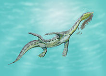 Ceresiosaurus 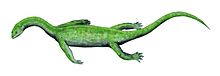 Keichousaurus |
|||
|
||||
|
||||
|
Guizhou and Hubei, China |
|||
†Placodonts
Placodonts of the Anisian | ||||
|---|---|---|---|---|
| Taxa |
Presence |
Location |
Description |
Images |
|
 Cyamodus  Paraplacodus |
|||
|
Northern Italy |
|||
†Thalattosaurians
Thalattosauria of the Anisian | ||||
|---|---|---|---|---|
| Taxa |
Presence |
Location |
Description |
Images |
|
Italy |
A very thin, elongated creature (about 2 meters long) that probably swam like an eel, that was probably a fish eater and hunted in deep waters, based on its large eyes (which would allow it to see better in dark water) and the protective bony ring around them (also seen in ichthyosaurs), which prevented them from getting squashed in by the immense water pressure at great depths. |
 Askeptosaurus |
|
†Ceratitida
Ananorites
Arthaberites
Beyrichites
Bosnites
Buddhaites
Bukowskiites
Caucasites
Danubites
Gangadharites
Japonites
Laboceras
Longobarditoides
Mesocladiscites
Noetlingites
Parapinacoceras
Parasageceras
Phyllocladiscites
Proavites
Pseudodanubites
Psilocladiscites
Salterites
Tropigymnites
Xiphogymnites
Pararcestes
Sageceras
Lower
Alloptychites
Anagymnites
Grambergia
Groenlandites
Gymnites
Lenotropites
Pearylandites
Silberlingites
Isculites
Stenopopanoceras
Middle
Acrochordiceras
Alanites
Anagymnotoceras
Arctohungarites
Balatonites
Bulogites
Cuccoceras
Czekanowskites
Epacrochordiceras
Hollandites
Huishuites
Inaigymnites
Ismidites
Kiparisovia
Malletophychites
Nicomedites
Phillipites
Platycuccoceras
Pronoetlingites
Reiflingites
Discoptychites
Intornites
Nevadisculites
Paraceratites
Parapopanoceras
Proarcestes
Longobardites
Ptychites
Upper
Amphipopanoceras
Aplococeras
Arctogymnites
Eudiscoceras
Eutomoceras
Gymnotoceras
Halilucites
Judicarites
Kellnerites
Metadinarites
Nevadites
Parakellnerites
Proteusites
Repossia
Semiornites
Serpianites
Stoppaniceras
Ticinites
Tozerites
Tropigastrites
Joannites
Epigymnites
Ceratites
Flexoptychites
Frechites
Norites
Gevanites
Hungarites
†Phylloceratida
Spinoleiophyllites
Ussurites
Monophyllites
Nautilida
Trachynautilus
Thuringionautilus
Styrionautilus
Lower
Indonautilus
Sibyllonautilus
Middle
Paranautilus
Upper
Holconautilus
Proclydonautilus
†Aulacocerida
Crassiatractites
Breviatractites
Lower
Mojsisovicsteuthis
Pterioida
Ramonalinidae
References
Notes
^ "International Chronostratigraphic Chart" (PDF). International Commission on Stratigraphy. 2018..mw-parser-output cite.citation{font-style:inherit}.mw-parser-output .citation q{quotes:"""""""'""'"}.mw-parser-output .citation .cs1-lock-free a{background:url("//upload.wikimedia.org/wikipedia/commons/thumb/6/65/Lock-green.svg/9px-Lock-green.svg.png")no-repeat;background-position:right .1em center}.mw-parser-output .citation .cs1-lock-limited a,.mw-parser-output .citation .cs1-lock-registration a{background:url("//upload.wikimedia.org/wikipedia/commons/thumb/d/d6/Lock-gray-alt-2.svg/9px-Lock-gray-alt-2.svg.png")no-repeat;background-position:right .1em center}.mw-parser-output .citation .cs1-lock-subscription a{background:url("//upload.wikimedia.org/wikipedia/commons/thumb/a/aa/Lock-red-alt-2.svg/9px-Lock-red-alt-2.svg.png")no-repeat;background-position:right .1em center}.mw-parser-output .cs1-subscription,.mw-parser-output .cs1-registration{color:#555}.mw-parser-output .cs1-subscription span,.mw-parser-output .cs1-registration span{border-bottom:1px dotted;cursor:help}.mw-parser-output .cs1-ws-icon a{background:url("//upload.wikimedia.org/wikipedia/commons/thumb/4/4c/Wikisource-logo.svg/12px-Wikisource-logo.svg.png")no-repeat;background-position:right .1em center}.mw-parser-output code.cs1-code{color:inherit;background:inherit;border:inherit;padding:inherit}.mw-parser-output .cs1-hidden-error{display:none;font-size:100%}.mw-parser-output .cs1-visible-error{font-size:100%}.mw-parser-output .cs1-maint{display:none;color:#33aa33;margin-left:0.3em}.mw-parser-output .cs1-subscription,.mw-parser-output .cs1-registration,.mw-parser-output .cs1-format{font-size:95%}.mw-parser-output .cs1-kern-left,.mw-parser-output .cs1-kern-wl-left{padding-left:0.2em}.mw-parser-output .cs1-kern-right,.mw-parser-output .cs1-kern-wl-right{padding-right:0.2em}
^ According to Gradstein et al. (2004); Brack et al. (2005) give 248 to 241 Ma
^ The GSSP was established by Grǎdinaru et al. (2007)
Literature
.mw-parser-output .smallcaps{font-variant:small-caps}
Brack, P.; Rieber, H.; Nicora, A. & Mundil, R.; 2005: The Global boundary Stratotype Section and Point (GSSP) of the Ladinian Stage (Middle Triassic) at Bagolino (Southern Alps, Northern Italy) and its implications for the Triassic time scale, Episodes 28(4), pp. 233–244.
Grǎdinaru, E.; Orchard, M.J.; Nicora, A.; Gallet, Y.; Besse, J.; Krystyn, L.; Sobolev, E.S.; Atudorei, N.-V. & Ivanova, D.; 2007: The Global Boundary Stratotype Section and Point (GSSP) for the base of the Anisian Stage: Deşli Caira Hill, North Dobrogea, Romania, Albertiana 36, pp. 54–71.
Gradstein, F.M.; Ogg, J.G. & Smith, A.G.; 2004: A Geologic Time Scale 2004, Cambridge University Press.
External links
- GeoWhen Database - Anisian
Lower Triassic timescale at the website of the subcommission for stratigraphic information of the ICS
Lower Triassic timescale at the website of Norges Network of offshore records of geology and stratigraphy.
Coordinates: 45°04′27″N 28°48′08″E / 45.0742°N 28.8022°E / 45.0742; 28.8022


Comments
Post a Comment