 Mixing
Orland Township, Cook County, Illinois
Orland Township | |
|---|---|
Township | |
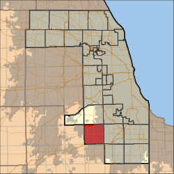 Location in Cook County | |
 Cook County's location in Illinois | |
| Coordinates: 41°36′06″N 87°51′13″W / 41.60167°N 87.85361°W / 41.60167; -87.85361Coordinates: 41°36′06″N 87°51′13″W / 41.60167°N 87.85361°W / 41.60167; -87.85361 | |
| Country | United States |
| State | Illinois |
| County | Cook |
| Area | |
| • Total | 3 sq mi (94.45 km2) |
| • Land | 35.73 sq mi (92.55 km2) |
| • Water | 0.73 sq mi (1.89 km2) 2.00% |
| Elevation |
705 ft (215 m) |
| Population (2010) | |
| • Estimate (2016)[1] |
99,667 |
| • Density | 2,730/sq mi (1,054.1/km2) |
| Time zone | UTC-6 (CST) |
| • Summer (DST) | UTC-5 (CDT) |
| ZIP codes | 60452, 60462, 60467, 60477, 60487 |
| FIPS code | 17-031-56614 |
| Website | orlandtownship.org |
Orland Township is one of 29 townships in Cook County, Illinois, USA. As of the 2010 census, its population was 97,558.[2]
Contents
1 Geography
1.1 Boundaries
1.2 Cities, towns, villages
1.3 Adjacent townships
1.4 Cemeteries
1.5 Major highways
1.6 Lakes
1.7 Landmarks
2 Demographics
3 Political districts
4 References
5 External links
Geography
According to the United States Census Bureau, Orland Township covers an area of 36.47 square miles (94.5 km2); of this, 35.74 square miles (92.6 km2) (97.99 percent) is land and 0.73 square miles (1.9 km2) (1.89 square kilometers, 2 percent) is water. It includes the entire village of Orland Hills, almost all of Orland Park, as well as a large portion of Tinley Park.
Boundaries
Orland Township is bordered by Harlem Avenue (Illinois Route 43) on the east, 135th Street on the north, Will-Cook Road on the west (where Cook County and Will County share a border), and 183rd Street on the south (which is also the Cook-Will county border).
Cities, towns, villages
- Orland Hills
- Orland Park
- Tinley Park
Adjacent townships
Palos Township (north)
Worth Township (northeast)
Bremen Township (east)
Rich Township (southeast)
Frankfort Township, Will County (south)
New Lenox Township, Will County (southwest)
Homer Township, Will County (west)
Lemont Township (northwest)
Cemeteries
The township contains these four cemeteries: Cooper, German Methodist, Old German Methodist and Orland Park.
Major highways
 U.S. Route 6
 Illinois Route 7
Lakes
- Ashbourne Lake
- Laguna Lake
- Turtlehead Lake
Landmarks
- Orland Grove Forest Preserve (south three-quarters)
- Orland Tract Forest Preserve
- Tinley Creek Woods (Cook County Forest Preserves) (west three-quarters)
Demographics
| Historical population | |||
|---|---|---|---|
| Census | Pop. | %± |
|
| Est. 2016 | 99,667 | [1] | |
| U.S. Decennial Census[3] | |||
Political districts
- Illinois' 1st congressional district
- State House District 28
- State House District 35
- State House District 37
- State House District 81
- State Senate District 14
- State Senate District 18
- State Senate District 19
- State Senate District 41
There are many political organizations in Orland Township. The Regular Democratic Organization for Orland Township, represents all Democratic candidates.
References
"Orland Township, Cook County, Illinois". Geographic Names Information System. United States Geological Survey. Retrieved 2010-01-10..mw-parser-output cite.citation{font-style:inherit}.mw-parser-output .citation q{quotes:"""""""'""'"}.mw-parser-output .citation .cs1-lock-free a{background:url("//upload.wikimedia.org/wikipedia/commons/thumb/6/65/Lock-green.svg/9px-Lock-green.svg.png")no-repeat;background-position:right .1em center}.mw-parser-output .citation .cs1-lock-limited a,.mw-parser-output .citation .cs1-lock-registration a{background:url("//upload.wikimedia.org/wikipedia/commons/thumb/d/d6/Lock-gray-alt-2.svg/9px-Lock-gray-alt-2.svg.png")no-repeat;background-position:right .1em center}.mw-parser-output .citation .cs1-lock-subscription a{background:url("//upload.wikimedia.org/wikipedia/commons/thumb/a/aa/Lock-red-alt-2.svg/9px-Lock-red-alt-2.svg.png")no-repeat;background-position:right .1em center}.mw-parser-output .cs1-subscription,.mw-parser-output .cs1-registration{color:#555}.mw-parser-output .cs1-subscription span,.mw-parser-output .cs1-registration span{border-bottom:1px dotted;cursor:help}.mw-parser-output .cs1-ws-icon a{background:url("//upload.wikimedia.org/wikipedia/commons/thumb/4/4c/Wikisource-logo.svg/12px-Wikisource-logo.svg.png")no-repeat;background-position:right .1em center}.mw-parser-output code.cs1-code{color:inherit;background:inherit;border:inherit;padding:inherit}.mw-parser-output .cs1-hidden-error{display:none;font-size:100%}.mw-parser-output .cs1-visible-error{font-size:100%}.mw-parser-output .cs1-maint{display:none;color:#33aa33;margin-left:0.3em}.mw-parser-output .cs1-subscription,.mw-parser-output .cs1-registration,.mw-parser-output .cs1-format{font-size:95%}.mw-parser-output .cs1-kern-left,.mw-parser-output .cs1-kern-wl-left{padding-left:0.2em}.mw-parser-output .cs1-kern-right,.mw-parser-output .cs1-kern-wl-right{padding-right:0.2em}
- United States Census Bureau 2007 TIGER/Line Shapefiles
- United States National Atlas
- [1]
^ ab "Population and Housing Unit Estimates". Retrieved June 9, 2017.
^ "Geographic Identifiers: 2010 Demographic Profile Data (DP-1): Orland township, Cook County, Illinois". U.S. Census Bureau, American Factfinder. Retrieved March 21, 2013.
^ "Census of Population and Housing". Census.gov. Retrieved June 4, 2016.
External links
- Orland Township official website
- History of Orland, Il.
- City-Data.com
- Illinois State Archives
- Township Officials of Illinois
- Cook County official site
Municipalities and communities of Cook County, Illinois, United States | ||
|---|---|---|
County seat: Chicago | ||
| Cities |
|
|
| Town |
|
|
| Villages |
|
|
| Townships |
|
|
| Unincorporated communities |
|
|
| Footnotes | ‡This populated place also has portions in an adjacent county or counties |
|


Comments
Post a Comment