 Mixing
Loire (department)
Loire | ||
|---|---|---|
Department | ||
| ||
 Location of Loire in France | ||
| Coordinates: 45°05′N 04°05′E / 45.083°N 4.083°E / 45.083; 4.083Coordinates: 45°05′N 04°05′E / 45.083°N 4.083°E / 45.083; 4.083 | ||
| Country | France | |
| Region | Auvergne-Rhône-Alpes | |
| Prefecture | Saint-Étienne | |
| Subprefectures | Montbrison Roanne | |
| Government | ||
| • President of the General Council | Bernard Bonne (UMP) | |
| Area 1 | ||
| • Total | 4,781 km2 (1,846 sq mi) | |
| Population (2016) | ||
| • Total | 761,997 | |
| • Rank | 30th | |
| • Density | 160/km2 (410/sq mi) | |
| Time zone | UTC+1 (CET) | |
| • Summer (DST) | UTC+2 (CEST) | |
| Department number | 42 | |
| Arrondissements | 3 | |
| Cantons | 21 | |
| Communes | 326 | |
^1 French Land Register data, which exclude estuaries, and lakes, ponds, and glaciers larger than 1 km2 | ||

Loire (French pronunciation: [lwaʁ]; Arpitan: Lêre; Occitan: Léger) is a department in Auvergne-Rhône-Alpes occupying the River Loire's upper reaches.
Contents
1 History
2 Geography
3 Demographics
4 Politics
4.1 Current National Assembly Representatives
5 Tourism
6 See also
7 References
8 External links
History
Loire was created in 1793 when the Rhône-et-Loire department was split into two, about 3½ years after it was created. This was a response to counter-revolutionary activities in Lyon which, by population, was the country's second largest city. By splitting Rhône-et-Loire the government sought to protect the French Revolution from the potential power and influence of counter revolutionary activity in the Lyon region.
The departmental capitals throughout its history are as follows:
Feurs 1793–1795
Montbrison 1795–1855
Saint-Étienne since 1855
Geography
Loire is part of the current administrative region of Auvergne-Rhône-Alpes and is surrounded by the departments of Rhône, Isère, Ardèche, Haute-Loire, Puy-de-Dôme, Allier, and Saône-et-Loire.
The River Loire traverses the department from south to north.
The Loire department is split into three arrondissements:
- Arrondissement of Montbrison
- Arrondissement of Roanne
- Arrondissement of Saint-Étienne
Parts of the department belong to Parc naturel régional Livradois-Forez.
Demographics
The inhabitants of the department are called Ligériens.
The industrial city of Saint-Étienne with its suburbs contains some 290,000 of the area's 728,542 inhabitants.
Politics
Current National Assembly Representatives
| Constituency | Member[1] | Party | |
|---|---|---|---|
Loire's 1st constituency | Régis Juanico | Socialist Party | |
Loire's 2nd constituency | Jean-Michel Mis | La République En Marche! | |
Loire's 3rd constituency | Valéria Faure-Muntian | La République En Marche! | |
Loire's 4th constituency | Dino Cinieri | The Republicans | |
Loire's 5th constituency | Nathalie Sarles | Modem | |
Loire's 6th constituency | Julien Borowczyk | La République En Marche! | |
Tourism

Saint-Étienne

Château de La Roche

Château de Grangent

Champdieu
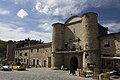
Sainte-Croix-en-Jarez, one of The Most Beautiful Villages of France


See also
- Auvergne-Rhône-Alpes
- Cantons of the Loire department
- Communes of the Loire department
- Arrondissements of the Loire department
- Loire coal mining basin
- Loire General Council
References
^ http://www.assemblee-nationale.fr/
External links
(in French) Prefecture website
(in French) Loire General Council
Authority control |
|
|---|


Comments
Post a Comment