 Mixing
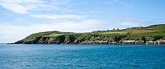
Cape Clear Island
| Native name: Cléire | |
|---|---|
 | |
 Cape Clear Island Cape Clear Island (Ireland) | |
| Geography | |
| Location | Carbery's Hundred Isles |
| Coordinates | 51°26′N 9°30′W / 51.433°N 9.500°W / 51.433; -9.500Coordinates: 51°26′N 9°30′W / 51.433°N 9.500°W / 51.433; -9.500 |
| Area | 6.7 km2 (2.6 sq mi) |
| Length | 5.2 km (3.23 mi) |
| Width | 2.4 km (1.49 mi) |
| Highest elevation | 160 m (520 ft) |
| Highest point | Cnoicín an tSeabhaic |
| Administration | |
Ireland | |
| Province | Munster |
| County | Cork |
| Barony | Carbery West |
| Demographics | |
| Population | 124 (2011) |
| Pop. density | 18.6 /km2 (48.2 /sq mi) |
| Additional information | |
| The island is a Gaeltacht | |
Clear Island or Cape Clear Island (officially known by its Irish name: Cléire, and sometimes also called Oileán Chléire) lies south-west of County Cork in Ireland. It is the southernmost inhabited part of the island of Ireland and has a population of over 100 people. Officially it is a Gaeltacht (Irish-speaking area), and most inhabitants speak Irish and English. Its nearest neighbour is Sherkin Island, 2 km (1 mi) east of the island. The island is divided into east and west halves by an isthmus called the Waist, with North Harbour to landward and South Harbour on the seaward side.[1] Ferries sail from the North Harbour to Schull and Baltimore on the mainland. The South Harbour is a popular berth for yachts.
Contents
1 History
2 Culture and language
3 Wildlife
4 References
5 Further reading
6 External links
History
Archaeological sites on the island include a prehistoric cup-marked stone (moved to the island's museum), a fulacht fiadh at Gort na Lobhar, a neolithic passage tomb at Cill Leire Forabhain, several standing stones around the island, a promontory fort at Dún an Óir, and a signal tower dating from the Napoleonic Wars.[2][3][4] The island also has a number of early Christian sites, and is reputed to be the birthplace of Saint Ciarán of Saigir. The ruins of 12th century church are close to the main pier.[5]
The island had a population of over 1,052 before the 19th century famine, and the population of Cape Clear is currently less than one-eighth that figure. The island's primary school was built in 1897, and visited by President of Ireland Mary McAleese in 1998.[citation needed]
Cape Clear was originally supplied with electricity produced by diesel generators on the island, but circa 1995 these were replaced with a submarine power cable.[6]
| Historical population | ||||||||||||||||||||||||||||||||||||||||||||||||||||||||||||||||||||||||||||||||
|---|---|---|---|---|---|---|---|---|---|---|---|---|---|---|---|---|---|---|---|---|---|---|---|---|---|---|---|---|---|---|---|---|---|---|---|---|---|---|---|---|---|---|---|---|---|---|---|---|---|---|---|---|---|---|---|---|---|---|---|---|---|---|---|---|---|---|---|---|---|---|---|---|---|---|---|---|---|---|---|---|
|
|
|
||||||||||||||||||||||||||||||||||||||||||||||||||||||||||||||||||||||||||||||
| Source: Central Statistics Office. "CNA17: Population by Off Shore Island, Sex and Year". CSO.ie. Retrieved October 12, 2016..mw-parser-output cite.citation{font-style:inherit}.mw-parser-output .citation q{quotes:"""""""'""'"}.mw-parser-output .citation .cs1-lock-free a{background:url("//upload.wikimedia.org/wikipedia/commons/thumb/6/65/Lock-green.svg/9px-Lock-green.svg.png")no-repeat;background-position:right .1em center}.mw-parser-output .citation .cs1-lock-limited a,.mw-parser-output .citation .cs1-lock-registration a{background:url("//upload.wikimedia.org/wikipedia/commons/thumb/d/d6/Lock-gray-alt-2.svg/9px-Lock-gray-alt-2.svg.png")no-repeat;background-position:right .1em center}.mw-parser-output .citation .cs1-lock-subscription a{background:url("//upload.wikimedia.org/wikipedia/commons/thumb/a/aa/Lock-red-alt-2.svg/9px-Lock-red-alt-2.svg.png")no-repeat;background-position:right .1em center}.mw-parser-output .cs1-subscription,.mw-parser-output .cs1-registration{color:#555}.mw-parser-output .cs1-subscription span,.mw-parser-output .cs1-registration span{border-bottom:1px dotted;cursor:help}.mw-parser-output .cs1-ws-icon a{background:url("//upload.wikimedia.org/wikipedia/commons/thumb/4/4c/Wikisource-logo.svg/12px-Wikisource-logo.svg.png")no-repeat;background-position:right .1em center}.mw-parser-output code.cs1-code{color:inherit;background:inherit;border:inherit;padding:inherit}.mw-parser-output .cs1-hidden-error{display:none;font-size:100%}.mw-parser-output .cs1-visible-error{font-size:100%}.mw-parser-output .cs1-maint{display:none;color:#33aa33;margin-left:0.3em}.mw-parser-output .cs1-subscription,.mw-parser-output .cs1-registration,.mw-parser-output .cs1-format{font-size:95%}.mw-parser-output .cs1-kern-left,.mw-parser-output .cs1-kern-wl-left{padding-left:0.2em}.mw-parser-output .cs1-kern-right,.mw-parser-output .cs1-kern-wl-right{padding-right:0.2em} | ||||||||||||||||||||||||||||||||||||||||||||||||||||||||||||||||||||||||||||||||
Culture and language
The island is officially identified as a Gaeltacht (Irish-speaking) area, and according to a 2007 report there were 127 people over the age of 3 living on the island, of whom 62 (48.8%) spoke Irish daily outside the education system.[7]
Every first weekend of September, Cape hosts the Cape Clear Island International Storytelling Festival, which has been running annually since 1994. The festival features professional international storytellers from all over the world.[8]
Wildlife
Seals, basking sharks and dolphins are found in the surrounding water, while sea pinks and honeysuckle are common plants on the land.[9] Cape Clear is home to a lighthouse and a bird observatory. Cape Clear is popular with bird watchers and at times of the year is home to many species of migratory birds which are attracted to its climate, which is milder than the mainland.[10]Birdlife includes black and common guillemots, cormorants and storm petrels.
References
^ David Walsh, Oileáin: A Guide to the Irish Islands (Pesda Press, 2004;
ISBN 0953195694), p. 64.
^ "Archaeological & Historical Sites on Cape Clear Island". Cape Clear Museum. Retrieved 6 April 2015.
^ "Cape Clear Heritage Centre". Cape Clear Cooperative. Retrieved 6 April 2015.
^ "Cape Clear Island - Oileán Chléire". Fáilte Ireland. Retrieved 6 April 2015.
^ Archaeological Inventory of County Cork, Vol 1 (West Cork). Office of Public Works. 1992. ISBN 9780707601755.
^ "Cape Clear Museum and Archive". Capeclearmuseum.ie. Retrieved 19 September 2016.Electricity and house water was a 'luxury' that only arrived on the island in the 1970s and a submarine cable bringing electricity from the mainland 8 miles away arrived only about 1995.
^ Comprehensive Linguistic Study of the Use of Irish in the Gaeltacht, Principal Findings (PDF). COGG.ie (An Chomhairle um Oideachas Gaeltachta & Gaelscolaíochta) (Report). Department of Community, Rural and Gaeltacht Affairs. 2007. p. 19. Archived from the original (PDF) on 12 May 2015.
^ Cape Clear Storytelling
^ John Akeroyd, ed. (1996). The Wild Plants of Sherkin, Cape Clear and adjacent Islands of West Cork. Sherkin Island Marine Station. ISBN 9781870492584.
^ "Birdwatching Cape Clear". BirdWatch Ireland. Retrieved 5 April 2015.
Further reading
Cape Clear Island, Éamon Lankford, 1999
Ghostwritten, David Mitchell, 1999
Staideár Cuimsitheach Teangeolaíoch ar Úsáid na Gaeilge sa Ghaeltacht, Committee of Community, Rural and Gaeltacht Affairs, 2007
The Night Swimmer, Matt Bondurant, 2012
External links
| Wikimedia Commons has media related to Cape Clear. |
- Official website
- Suíomh Oifigiúil an Oileáin
- Official ferry website
Lists of Marilyns | |
|---|---|
| |
|
Authority control |
|
|---|


Comments
Post a Comment