 Mixing
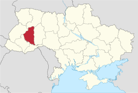
Ternopil Oblast
Ternopil Oblast Тернопільська область Ternopilska oblast | |||
|---|---|---|---|
Oblast | |||
| |||
Nickname(s): Тернопільщина (Ternopilshchyna) | |||
 | |||
| Country | |||
| Administrative center | Ternopil Chortkiv[1](1944) | ||
| Government | |||
| • Governor | Stepan Barna (Petro Poroshenko Bloc) | ||
| • Oblast council | 120 seats | ||
| • Chairperson | Vasyl Khominets (Svoboda) | ||
| Area | |||
| • Total | 13,823 km2 (5,337 sq mi) | ||
| Area rank | Ranked 22nd | ||
| Population (2006) | |||
| • Total | 1,107,294 | ||
| • Rank | Ranked 23rd | ||
| • Density | 80/km2 (210/sq mi) | ||
| Time zone | UTC+2 (EET) | ||
| • Summer (DST) | UTC+3 (EEST) | ||
| Postal code | ? | ||
| Area code | +380-35 | ||
| ISO 3166 code | UA-61 | ||
| Raions | 17 | ||
Cities (total) | 14 | ||
| • Regional cities | 1 | ||
| Urban-type settlements | 17 | ||
| Villages | 1019 | ||
| FIPS 10-4 | UP22 | ||
| Website | www.adm.gov.te.ua | ||

Ternopil Oblast (Ukrainian: Тернопільська область, translit. Ternopilska oblast; also referred to as Ternopilshchyna - Ukrainian: Тернопільщина, Polish: Obwód Tarnopolski) is an oblast (province) of Ukraine. Its administrative center is Ternopil, through which flows the Seret River, a tributary of the Dnister.
One of the natural wonders of the region are its cave complexes.[2] Although Ternopil Oblast is among the smallest regions in Ukraine, over 100 caves have been discovered there.[2] Scientists believe these are only 20% of all possible caves in the region.[2] The biggest cave is Optymistychna Cave.[2] Measuring 230 km (140 mi) in total length, it is the longest cave in Eurasia and the fifth longest in the world (see list of longest caves).[2] Twenty percent of the land in the region is chernozem soil.[2]
Ternopil Oblast has 34 castles.[2] The most prominent is the Zbarazh Castle.[2] Its fortifications alone expand over 16 ha (40 acres).[2] In the summer of 1649 the castle was the epicenter of a standoff between troops of Bohdan Khmelnytsky and the army of the Polish-Lithuanian Commonwealth. These events were later described in the novel "With Fire and Sword" by Polish Nobel Prize recipient Henryk Sienkiewicz.[2]
Dniester Canyon passes through the oblast; it is considered one of the wonders of Ukraine stretching for 250 km (160 mi).[2]
Contents
1 Geography
2 History
3 Points of interest
4 Population
4.1 National composition
4.2 Age structure
4.3 Median age
5 Economy and Transportation
6 Subdivisions
7 Personalities
8 See also
9 References
10 External links
Geography
The oblast is located in Western Ukraine and has an area of 13,800 km². It is situated at the western part of the Podilian Upland, which is known for its rocky terrain. Among noticeable mountains there are the Kremenets Mountains. The oblast is also famous for its caves.
One of the major rivers in the country Dniester forms southern and southwestern borders of Ternopil Oblast with the adjacent Chernivtsi Oblast and Ivano-Frankivsk Oblast. Its tributaries that flow through the oblast include Zbruch, Seret, and Strypa among just few of them. The Seret River (not to be confused with Siret nor Seret) is a left tributary of the Dniester flowing through the oblast administrative center, i.e. Ternopil.
Ternopil Oblast is one of the two in the West Ukraine that do not have an international border. It is surrounded by five other oblasts of Ukraine: Chernivtsi Oblast - to the south, Ivano-Frankivsk Oblast - to the southwest, Lviv Oblast - to the northwest, Rivne Oblast - to the north, and Khmelnytskyi Oblast - to the east.
History
The oblast was created during the Second World War when both Nazi Germany and later the Soviet Union invaded Poland. Due to the Polish national policy in the area (Pacification action), many people favored the Soviet invasion of Eastern Galicia at first. However, soon thereafter, the Soviet security agencies started a witchhunt among nationally oriented members of Ukrainian resistance who emigrated to Poland after the Soviet-Ukrainian War as well as other reasons. Many people of local population regardless of their ethnic background were exiled to Siberia. On December 4, 1939 the voivodeship division in the West Ukraine was abolished and replaced with the existing Soviet administrative division oblast. Ternopil Oblast (originally Tarnopol Oblast) was established based mostly on the Tarnopol Voivodeship and southern portions of the Volhynian Voivodeship.
During the invasion of the Soviet Union by Nazi Germany, Ternopil became an object of fierce fighting between Soviet and German forces because of its importance as a rail transportation hub. During German occupation, the region (except for its Volhynian portion) became part of the District of Galicia and transferred to administration by the General Government. After the war, a destroyed residential section of Ternopil, near the river, was turned into an artificial lake rather than being rebuilt. Additionally, upon annexation to the Soviet Union's Ukrainian SSR, most ethnic Poles in the region were forcibly relocated to Poland, whose national borders had shifted far to the west. The area of the former Polish voivoideship was expanded by adding territory in the north, though the western-most parts were transferred to the Lviv oblast. After 1945 Soviet authorities also encouraged ethnic Russians to settle in territories newly annexed to the Soviet Union, including the Ternopil oblast, though western Ukraine remained considerably less Russian than eastern Ukraine.
As Ukraine achieved independence in the 1990s, western Ukraine remained the heartland of Ukrainian political and cultural nationalism, and the political affiliations of Ternopil voters reflected that viewpoint. In the first elections after independence, the People's Movement of Ukraine was the leading party in the oblast. A majority of oblast voters supported the Ukrainian nationalist-oriented Electoral Bloc Yuliya Tymoshenko in the Ukrainian parliamentary election, 2002. Over 88% of voters supported Yulia Tymoshenko of the All-Ukrainian Union "Fatherland" in the Ukrainian presidential election, 2010.
By 2005, the population of the oblast had grown to roughly 225,000, consisting primarily of ethnic Ukrainians with a large Russian or Russian-speaking minority. The city of Ternopil has important institutions of higher education, including two teacher's colleges, an international medical school with instruction in English, and one of three economics institutes in Ukraine.

Pochaiv Monastery
The religion of the majority is Eastern Rite Catholic (Uniate), though there is a notable Orthodox presence and a small Protestant minority. Many churches which were closed or destroyed under Soviet rule have rebuilt since independence. The local Jewish community, which was very large before 1939, was not reestablished after 1945. There are no active synagogues in the oblast and only a few isolated individuals affiliating with the Jewish faith.
Points of interest

Vyshnivets Palace

Dzhuryn Waterfall, one of the highest in Ukraine.
The oblast is known for its castles and fortresses. Due to the underfunding of the state program for the preservation of cultural heritage, many of objects of historical significance are in poor condition.
The following historic-cultural sites were nominated for the Seven Wonders of Ukraine.
Verteba cave, a cave in Borshchiv Raion
Bohyt, a hill near Zbruch River where was found the Zbruch idol (Husiatyn Raion)
Buchach Ratusha, a former town hall in Buchach
Pochaiv Lavra, located in the city of Pochaiv, one of the biggest holy places of Christian Orthodox in Ukraine
Zarvanytsia Spiritual Center, a big holy place of Greek Catholics of Podillia (Terebovlia Raion)
Vyshnivets Palace, a princely palace in Vyshnivets (Zbarazh Raion)
Camp UPA, a museum of Ukrainian resistance movement in Shumsk Raion
- Dzhuryn Waterfall
- Castles of Ternopil Region (Ternopil Castle, Berezhany Castle, Zbarazh Castle, and others)
Population
National composition
The population is predominantly Ukrainophone and about 98% consider themselves Ukrainians. Among the biggest minorities are Poles and Russians who combine 1.6% of the total population. Most of the population is bilingual and the Ukrainian language is accepted in daily communications. The estimated population is 1.1 million people (as of 2004).[citation needed]
In historical comparison, before World War II national composition was very different and according to the 1931 Polish Census Ukrainians were a slight majority in the Tarnopol Voivodeship at 54.8%, while there was almost no Russians. On the other hand, the Polish and Jewish population decreased drastically from 36.6% and 8.4% respectively.[citation needed]
Age structure
0-14 years: 15.7% (male 86,309/female 81,940)
15-64 years: 69.0% (male 360,305/female 381,271)
65 years and over: 15.3% (male 53,364/female 110,887) (2013 official)
Median age
total: 38.6 years
male: 35.8 years
female: 41.4 years (2013 official)
Economy and Transportation

Bridge near Terebovlia
The economy is predominantly agriculturally oriented. Among industries, there is a well developed food industry particularly sugar production, alcohol, and dairy (such as butter). There is also number of factories such as "Vatra" (lighting equipment), Ternopil Harvester Plant, "Orion" (radio communication) among a few.
Ternopil Oblast has an adequate network of highways, while the city of Ternopil is located at the intersection of main European corridors along the E50 and E85 highways. There is a small airport in Ternopil (Ternopil Airport) which however mostly is used for charter flights. There is a well developed railroad network which is a part of the Lviv Railways. Water transportation is very limited and mostly along the Dniester River.
Subdivisions
The Ternopil Oblast is administratively subdivided into 17 raions (districts), as well as 1 city (municipality) which is directly subordinate to the oblast government: Ternopil, the administrative center of the oblast. The average area of a raion is around 808 km2 (312 sq mi), the biggest one is Terebovlia Raion covering 1,130 km2 (440 sq mi) and the smallest one - Pidhaitsi Raion with 496 km2 (192 sq mi). The average population number is around 50.6 thousands which is just below the national average.

Map of Ternopil Oblast
| In English | In Ukrainian | Administrative Center | |
|---|---|---|---|
Berezhany Raion | Бережанський район Berezhanskyi raion | Berezhany (City) | |
Borshchiv Raion | Борщівський район Borshchivskyi raion | Borshchiv (City) | |
Buchach Raion | Бучацький район Buchatskyi raion | Buchach (City) | |
Chortkiv Raion | Чортківський район Chortkivskyi raion | Chortkiv (City) | |
Husiatyn Raion | Гусятинський район Husiatynskyi raion | Husiatyn (Urban-type settlement) | |
Kozova Raion | Козівський район Kozivskyi raion | Kozova (Urban-type settlement) | |
Kremenets Raion | Кременецький район Kremenetskyi raion | Kremenets (City) | |
Lanivtsi Raion | Лановецький район Lanovetskyi raion | Lanivtsi (City) | |
Monastyryska Raion | Монастириський район Monastyryskyi raion | Monastyryska (City) | |
Pidhaitsi Raion | Підгаєцький район Pidhayetskyi raion | Pidhaitsi (City) | |
Pidvolochysk Raion | Підволочиський район Pidvolochyskyi raion | Pidvolochysk (Urban-type settlement) | |
Shumsk Raion | Шумський район Shumskyi raion | Shumsk (City) | |
Terebovlia Raion | Теребовлянський район Terebovlanskyi raion | Terebovlia (City) | |
Ternopil Raion | Тернопільський район Ternopilskyi raion | Ternopil (City) | |
Zalishchyky Raion | Заліщицький район Zalishchytskyi raion | Zalishchyky (City) | |
Zbarazh Raion | Збаразький район Zbarazkyi raion | Zbarazh (City) | |
Zboriv Raion | Зборівський район Zborivskyi raion | Zboriv (City) |
Personalities
In town of Buchach was born a Nobel Prize recipient, writer Shmuel Yosef Agnon.[2] The prize was given for works about fate of Galician Jews.[2] Agnon worked for a Lviv newspaper, but after refusal to serve in the army he moved to Mandatory Palestine.[2] In Ukraine he published over 70 of his early works.[2]
Mike Mazurki, American professional athlete[3] and actor 196 cm (6 ft 5 in) in height
See also
- Subdivisions of Ukraine
- List of Canadian place names of Ukrainian origin
References
^ Snitovsky, O. Five centuries of Ternopil. The city of Hetman Jan and mason Leontiy[permanent dead link]. Ukrinform. 28 August 2015
^ abcdefghijklmno Tell about Ukraine. Ternopil Oblast. 24 Kanal (youtube).
^ wrestler, football and basketball
External links
| Wikimedia Commons has media related to Ternopil Oblast. |
- Ternopil Council website
Places adjacent to Ternopil Oblast | ||||||||||
|---|---|---|---|---|---|---|---|---|---|---|
| ||||||||||
Administrative center: Ternopil | |||||
| Raions |
| ||||
| Cities |
| ||||
| |||||
Capital: Kiev | |
| Oblasts |
|
| Cities with special status |
|
| Autonomous republic |
|
| Administrative centers |
|
1Claimed and controlled by Russia as the Republic of Crimea and the Federal City of Sevastopol 2Regions are nearly controlled by Pro-Russian seperatists states of Donetsk People's Republic and Luhansk People's Republic | |
Coordinates: 49°23′35″N 25°33′35″E / 49.39306°N 25.55972°E / 49.39306; 25.55972
Authority control |
|
|---|


Comments
Post a Comment