 Mixing
Gladstone, Manitoba
| Gladstone | |
|---|---|
| Unincorporated community | |
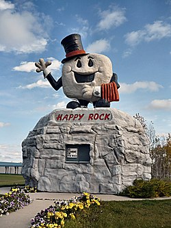 Happy Rock | |
| Nickname(s): Happy Rock | |
 Gladstone Location within Manitoba Show map of Manitoba 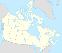 Gladstone Location within Canada Show map of Canada  Gladstone Location within North America Show map of North America | |
| Coordinates: 50°08′00″N 98°34′12″W / 50.1333°N 98.5700°W / 50.1333; -98.5700 | |
| Country | Canada |
| Province | Manitoba |
| Municipality | WestLake – Gladstone |
| Population (2011) | |
| • Total | 889 |
Gladstone is an unincorporated urban community in the Municipality of WestLake – Gladstone within the Canadian province of Manitoba that held town status prior to January 1, 2015. It is located on the Yellowhead Highway at the intersection with Highway 34. The Gladstone railway station receives Via Rail service.
Contents
1 History
2 Happy Rock
3 Climate
4 Notable people
5 References
6 External links
History
The first known name for the area was Third Crossing and when settlement became significant in 1872 the community was renamed as Palestine. When the community was incorporated in 1882, it was named after the British Prime Minister of the time William Ewart Gladstone.
Happy Rock
Gladstone is often referred to as "Happy Rock". This is the name given to the community's monument located along Highway 16 which acts as the symbol and mascot of the community. The Happy Rock monument also acts as the visitor information centre and is a vital part of the tourism in the community. On July 5, 2010, Canada Post made a commemorative stamp of the Happy Rock as part of its Roadside Attractions collection.[1]
Climate
| Climate data for Gladstone | |||||||||||||
|---|---|---|---|---|---|---|---|---|---|---|---|---|---|
| Month | Jan | Feb | Mar | Apr | May | Jun | Jul | Aug | Sep | Oct | Nov | Dec | Year |
| Record high °C (°F) | 8 (46) | 10 (50) | 16.7 (62.1) | 36 (97) | 39 (102) | 38 (100) | 37 (99) | 40.5 (104.9) | 38.5 (101.3) | 28.5 (83.3) | 21.7 (71.1) | 8.9 (48) | 40.5 (104.9) |
| Average high °C (°F) | −11.1 (12) | −8 (18) | −0.9 (30.4) | 10.9 (51.6) | 19.3 (66.7) | 23.6 (74.5) | 26.7 (80.1) | 25 (77) | 18.8 (65.8) | 11.7 (53.1) | −0.1 (31.8) | −9 (16) | 8.9 (48) |
| Daily mean °C (°F) | −16.6 (2.1) | −13.6 (7.5) | −6.4 (20.5) | 4.2 (39.6) | 11.9 (53.4) | 16.7 (62.1) | 19.6 (67.3) | 17.8 (64) | 12.1 (53.8) | 5.6 (42.1) | −4.8 (23.4) | −14.1 (6.6) | 2.7 (36.9) |
| Average low °C (°F) | −22 (−8) | −19.3 (−2.7) | −11.9 (10.6) | −2.5 (27.5) | 4.5 (40.1) | 9.8 (49.6) | 12.4 (54.3) | 10.5 (50.9) | 5.4 (41.7) | −0.5 (31.1) | −9.6 (14.7) | −19.3 (−2.7) | −3.5 (25.7) |
| Record low °C (°F) | −42.2 (−44) | −42.2 (−44) | −35.6 (−32.1) | −31.1 (−24) | −10.5 (13.1) | −1 (30) | 2 (36) | 0 (32) | −7.2 (19) | −23 (−9) | −37 (−35) | −41 (−42) | −42.2 (−44) |
| Average precipitation mm (inches) | 16.9 (0.665) | 15.8 (0.622) | 23.4 (0.921) | 31.5 (1.24) | 54.7 (2.154) | 71.7 (2.823) | 66.3 (2.61) | 72 (2.83) | 55.7 (2.193) | 29.8 (1.173) | 19.7 (0.776) | 19 (0.75) | 476.3 (18.752) |
| Source: Environment Canada[2] | |||||||||||||
Notable people
W. L. Morton, Canadian historian
Andy Murray (ice hockey), former NHL head coach
References
^ Canada Post Stamp Details, July to September 2010, p,8, Volume XIX, No. 3
^ Environment Canada - Canadian Climate Normals 1971-2000—Canadian Climate Normals 1971–2000, accessed 19 April 2011
- Town of Gladstone Community Profile
- Third Crossing: A History of the Town and District of Gladstone in the Province of Manitoba (1946) Margaret Morton Fahrni and W.L. Morton, Winnipeg.
External links
| Wikimedia Commons has media related to Gladstone, Manitoba. |
- Map of Gladstone at Statcan
Division No. 8, Manitoba (Central Manitoba) | ||||
|---|---|---|---|---|
| Towns |
|  | ||
| Villages |
| |||
| Rural municipalities |
| |||
| First Nations |
| |||
| Indian reserves |
| |||
| Unincorporated communities |
| |||
| ||||
| Subdivisions |
| ||
|---|---|---|---|
| Cities |
| ||
| Towns |
| ||
| Villages |
| ||
| |||
Coordinates: 50°13′33″N 98°57′00″W / 50.22583°N 98.95000°W / 50.22583; -98.95000
This Manitoba location article is a stub. You can help Wikipedia by expanding it. |


Comments
Post a Comment