 Mixing
Bourbon, Missouri
Bourbon, Missouri | |
|---|---|
City | |
 Location of Bourbon, Missouri | |
| Coordinates: 38°9′17″N 91°14′39″W / 38.15472°N 91.24417°W / 38.15472; -91.24417Coordinates: 38°9′17″N 91°14′39″W / 38.15472°N 91.24417°W / 38.15472; -91.24417[1] | |
| Country | United States |
| State | Missouri |
| County | Crawford |
| Area [2] | |
| • Total | 1.34 sq mi (3.46 km2) |
| • Land | 1.34 sq mi (3.46 km2) |
| • Water | 0.00 sq mi (0.00 km2) |
| Elevation [1] |
942 ft (287 m) |
| Population (2010)[3] | |
| • Total | 1,632 |
| • Estimate (2017)[4] |
1,601 |
| • Density | 1,197.46/sq mi (462.38/km2) |
| Time zone | UTC-6 (Central (CST)) |
| • Summer (DST) | UTC-5 (CDT) |
| ZIP code | 65441 |
| Area code(s) | 573 |
| FIPS code | 29-07534[5] |
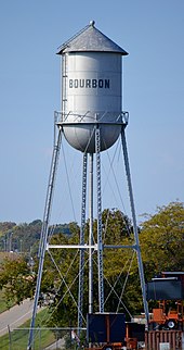
The historic water tower, no longer in use, is a landmark along Interstate 44.
Bourbon is a city in Crawford County, Missouri, United States. The population was 1,632 at the 2010 census.
Contents
1 History
2 Geography
3 Demographics
3.1 2010 census
3.2 2000 census
4 Education
5 Notable people
6 References
7 External links
History
A post office called Bourbon has been in operation since 1853.[6] The name Bourbon refers to bourbon whiskey and is believed to be the only town in the United States to be named after bourbon whiskey.[7][8]
Geography
The city is located in northern Crawford County on I-44 between Sullivan to the northeast and Cuba to the southwest.[9]
According to the United States Census Bureau, the city has a total area of 1.34 square miles (3.47 km2), all land.[10]
Demographics
| Historical population | |||
|---|---|---|---|
| Census | Pop. | %± |
|
| 1880 | 31 | — | |
| 1910 | 382 | — | |
| 1920 | 377 | −1.3% | |
| 1930 | 379 | 0.5% | |
| 1940 | 360 | −5.0% | |
| 1950 | 543 | 50.8% | |
| 1960 | 779 | 43.5% | |
| 1970 | 955 | 22.6% | |
| 1980 | 1,259 | 31.8% | |
| 1990 | 1,188 | −5.6% | |
| 2000 | 1,348 | 13.5% | |
| 2010 | 1,632 | 21.1% | |
| Est. 2017 | 1,601 | [4] | −1.9% |
| U.S. Decennial Census[11] | |||
2010 census
As of the census[3] of 2010, there were 1,632 people, 652 households, and 433 families residing in the city. The population density was 1,217.9 inhabitants per square mile (470.2/km2). There were 718 housing units at an average density of 535.8 per square mile (206.9/km2). The racial makeup of the city was 98.71% White, 0.12% Black or African American, 0.25% Native American, 0.37% Asian, 0.06% from other races, and 0.49% from two or more races. Hispanic or Latino of any race were 0.98% of the population.
There were 652 households of which 36.2% had children under the age of 18 living with them, 43.9% were married couples living together, 16.6% had a female householder with no husband present, 6.0% had a male householder with no wife present, and 33.6% were non-families. 28.8% of all households were made up of individuals and 13.2% had someone living alone who was 65 years of age or older. The average household size was 2.50 and the average family size was 3.03.
The median age in the city was 35 years. 27.9% of residents were under the age of 18; 9.1% were between the ages of 18 and 24; 25.5% were from 25 to 44; 22.4% were from 45 to 64; and 15.1% were 65 years of age or older. The gender makeup of the city was 48.8% male and 51.2% female.
2000 census
As of the census[5] of 2000, there were 1,348 people, 548 households, and 355 families residing in the city. The population density was 1,135.9 people per square mile (437.4/km²). There were 600 housing units at an average density of 505.6 per square mile (194.7/km²). The racial makeup of the city was 98.89% White, 0.07% African American, 0.45% Native American, and 0.59% from two or more races. Hispanic or Latino of any race were 0.52% of the population.
There were 548 households out of which 33.6% had children under the age of 18 living with them, 47.6% were married couples living together, 12.6% had a female householder with no husband present, and 35.2% were non-families. 31.8% of all households were made up of individuals and 16.4% had someone living alone who was 65 years of age or older. The average household size was 2.46 and the average family size was 3.10.
In the city the population was spread out with 28.8% under the age of 18, 8.1% from 18 to 24, 27.5% from 25 to 44, 19.7% from 45 to 64, and 15.9% who were 65 years of age or older. The median age was 35 years. For every 100 females, there were 98.5 males. For every 100 females age 18 and over, there were 88.6 males.
The median income for a household in the city was $30,240, and the median income for a family was $35,294. Males had a median income of $29,531 versus $20,391 for females. The per capita income for the city was $12,992. About 11.9% of families and 14.2% of the population were below the poverty line, including 19.4% of those under age 18 and 15.9% of those age 65 or over.
Education
Crawford County R-I School District operates one elementary school, one middle school, and Bourbon High School.[12]
Meramec Valley Christian School is the only private christian school in Bourbon.
Bourbon has a public library, a branch of the Crawford County Library District.[13]
Notable people
Brian Mistler, psychological author and international columnist, lived here as a child.
Taylor Louderman, Broadway actress known for Bring it On and Mean Girls, was raised in Bourbon as a child.
Ruthy Ross, Playboy actress and model known for winning "Bunny of the Year" in 1972 by the Playboy organization, and for appearing in "The Centerfold Girls" was born and raised in Bourbon, Missouri.
References
^ abc U.S. Geological Survey Geographic Names Information System: Bourbon, Missouri
^ "2017 U.S. Gazetteer Files". United States Census Bureau. Retrieved Jan 10, 2019..mw-parser-output cite.citation{font-style:inherit}.mw-parser-output .citation q{quotes:"""""""'""'"}.mw-parser-output .citation .cs1-lock-free a{background:url("//upload.wikimedia.org/wikipedia/commons/thumb/6/65/Lock-green.svg/9px-Lock-green.svg.png")no-repeat;background-position:right .1em center}.mw-parser-output .citation .cs1-lock-limited a,.mw-parser-output .citation .cs1-lock-registration a{background:url("//upload.wikimedia.org/wikipedia/commons/thumb/d/d6/Lock-gray-alt-2.svg/9px-Lock-gray-alt-2.svg.png")no-repeat;background-position:right .1em center}.mw-parser-output .citation .cs1-lock-subscription a{background:url("//upload.wikimedia.org/wikipedia/commons/thumb/a/aa/Lock-red-alt-2.svg/9px-Lock-red-alt-2.svg.png")no-repeat;background-position:right .1em center}.mw-parser-output .cs1-subscription,.mw-parser-output .cs1-registration{color:#555}.mw-parser-output .cs1-subscription span,.mw-parser-output .cs1-registration span{border-bottom:1px dotted;cursor:help}.mw-parser-output .cs1-ws-icon a{background:url("//upload.wikimedia.org/wikipedia/commons/thumb/4/4c/Wikisource-logo.svg/12px-Wikisource-logo.svg.png")no-repeat;background-position:right .1em center}.mw-parser-output code.cs1-code{color:inherit;background:inherit;border:inherit;padding:inherit}.mw-parser-output .cs1-hidden-error{display:none;font-size:100%}.mw-parser-output .cs1-visible-error{font-size:100%}.mw-parser-output .cs1-maint{display:none;color:#33aa33;margin-left:0.3em}.mw-parser-output .cs1-subscription,.mw-parser-output .cs1-registration,.mw-parser-output .cs1-format{font-size:95%}.mw-parser-output .cs1-kern-left,.mw-parser-output .cs1-kern-wl-left{padding-left:0.2em}.mw-parser-output .cs1-kern-right,.mw-parser-output .cs1-kern-wl-right{padding-right:0.2em}
^ ab "American FactFinder". United States Census Bureau. Retrieved 2012-07-08.
^ ab "Population and Housing Unit Estimates". Retrieved March 24, 2018.
^ ab "American FactFinder". United States Census Bureau. Archived from the original on 2013-09-11. Retrieved 2008-01-31.
^ "Post Offices". Jim Forte Postal History. Archived from the original on 6 March 2016. Retrieved 24 September 2016.
^ Eaton, David Wolfe (1916). How Missouri Counties, Towns and Streams Were Named. The State Historical Society of Missouri. p. 282.
^ "Crawford County Place Names, 1928–1945 (archived)". The State Historical Society of Missouri. Archived from the original on 24 June 2016. Retrieved 24 September 2016.CS1 maint: BOT: original-url status unknown (link)
^ Missouri Atlas & Gazetteer, DeLorme, 1998, First edition, p. 47
ISBN 0-89933-224-2
^ "US Gazetteer files 2010". United States Census Bureau. Archived from the original on 2012-01-24. Retrieved 2012-07-08.
^ "Census of Population and Housing". Census.gov. Archived from the original on May 12, 2015. Retrieved June 4, 2015.
^ "Schools". Crawford County RI School District. Retrieved 17 March 2018.
^ District, Crawford County Library. "Crawford County Library District". Crawford County Library District. Retrieved 2019-01-25.
External links
- Virtually Bourbon
Municipalities and communities of Crawford County, Missouri, United States | ||
|---|---|---|
County seat: Steelville | ||
| Cities |
|
 |
| Villages |
|
|
| Townships |
|
|
| Unincorporated communities |
|
|
| Ghost towns |
|
|
| Footnotes | ‡This populated place also has portions in an adjacent county or counties |
|


Comments
Post a Comment