 Mixing
Ballard County, Kentucky
Ballard County, Kentucky | |
|---|---|
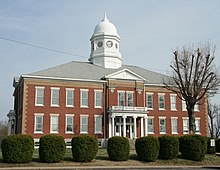 Ballard County Courthouse in Wickliffe | |
 Location within the U.S. state of Kentucky | |
 Kentucky's location within the U.S. | |
| Founded | 1842 |
| Named for | Bland Ballard |
| Seat | Wickliffe |
| Largest city | La Center |
| Area | |
| • Total | 274 sq mi (710 km2) |
| • Land | 247 sq mi (640 km2) |
| • Water | 27 sq mi (70 km2), 9.9% |
| Population | |
| • (2010) | 8,249 |
| • Density | 33/sq mi (13/km2) |
| Congressional district | 1st |
| Time zone | Central: UTC−6/−5 |
| Website | www.ballardcounty.ky.gov |
Ballard County is a county located in the U.S. state of Kentucky. As of the 2010 census, the population was 8,249.[1] Its county seat is Wickliffe.[2] The county was created by the Kentucky State Legislature in 1842 and is named for Captain Bland Ballard, a soldier, statesman, and member of the Kentucky General Assembly.[3] Ballard is now as of late 2017 a wet county
Ballard County is part of the Paducah, KY-IL Micropolitan Statistical Area.
Contents
1 History
2 Geography
2.1 State protected area
2.2 Adjacent counties
3 Demographics
4 Politics
4.1 Voter registration
4.2 Statewide elections
5 Communities
5.1 Cities
5.2 Census-designated places
5.3 Other unincorporated communities
6 Notable people
7 See also
8 References
History
Ballard County was formed from portions of Hickman County and McCracken County. It was named for Bland Ballard (1761–1853), a Kentucky pioneer and soldier who served as a scout for General George Rogers Clark during the American Revolutionary War, and later commanded a company during the War of 1812. On February 17, 1880, the courthouse was destroyed by a fire, which also destroyed most of the county's early records.[4] The county seat was transferred from Blandville to Wickliffe in 1882.[5]
Geography

Fort Jefferson Memorial Cross at the Confluence in Wickliffe
According to the U.S. Census Bureau, the county has a total area of 274 square miles (710 km2), of which 247 square miles (640 km2) is land and 27 square miles (70 km2) (9.9%) is water.[6]
State protected area
Axe Lake Swamp State Nature Preserve is a 458 acres (1.85 km2) nature preserve located in Ballard County, in the Barlow Bottoms. The preserve is part of the 3,000-acre (12 km2) Axe Lake Swamp wetlands complex which supports at least eight rare plant and animal species. The site has been recognized as a priority wetland in the North American Waterfowl Management Plan.[7]
Adjacent counties
Pulaski County, Illinois (north) – across the Ohio River
McCracken County (east)
Carlisle County (south)
Mississippi County, Missouri (southwest) – across the Mississippi River
Alexander County, Illinois (west) – across the Ohio River
Demographics
| Historical population | |||
|---|---|---|---|
| Census | Pop. | %± | |
| 1850 | 5,496 | — | |
| 1860 | 8,692 | 58.2% | |
| 1870 | 12,576 | 44.7% | |
| 1880 | 14,378 | 14.3% | |
| 1890 | 8,390 | −41.6% | |
| 1900 | 10,761 | 28.3% | |
| 1910 | 12,690 | 17.9% | |
| 1920 | 12,045 | −5.1% | |
| 1930 | 9,910 | −17.7% | |
| 1940 | 9,480 | −4.3% | |
| 1950 | 8,545 | −9.9% | |
| 1960 | 8,291 | −3.0% | |
| 1970 | 8,276 | −0.2% | |
| 1980 | 8,798 | 6.3% | |
| 1990 | 7,902 | −10.2% | |
| 2000 | 8,286 | 4.9% | |
| 2010 | 8,249 | −0.4% | |
| Est. 2016 | 8,054 | [8] | −2.4% |
| U.S. Decennial Census[9] 1790-1960[10] 1900-1990[11] 1990-2000[12] 2010-2013[1] | |||
As of the census[13] of 2000, there were 8,286 people, 3,395 households, and 2,413 families residing in the county. The population density was 33 per square mile (13/km2). There were 3,837 housing units at an average density of 15 per square mile (5.8/km2). The racial makeup of the county was 95.32% White, 2.87% Black or African American, 0.08% Native American, 0.18% Asian, 0.02% Pacific Islander, 0.08% from other races, and 1.44% from two or more races. 0.63% of the population were Hispanics or Latinos of any race.
There were 3,395 households out of which 30.70% had children under the age of 18 living with them, 59.60% were married couples living together, 8.00% had a female householder with no husband present, and 28.90% were non-families. 25.80% of all households were made up of individuals and 12.70% had someone living alone who was 65 years of age or older. The average household size was 2.39 and the average family size was 2.85.
The age distribution was 23.10% under the age of 18, 7.60% from 18 to 24, 27.70% from 25 to 44, 25.40% from 45 to 64, and 16.20% who were 65 years of age or older. The median age was 40 years. For every 100 females, there were 97.50 males. For every 100 females age 18 and over, there were 94.00 males.
The median income for a household in the county was $32,130, and the median income for a family was $41,386. Males had a median income of $32,345 versus $20,902 for females. The per capita income for the county was $19,035. About 10.70% of families and 13.60% of the population were below the poverty line, including 19.30% of those under age 18 and 15.40% of those age 65 or over.
Politics
Voter registration
| Ballard County Voter Registration & Party Enrollment as of November 17, 2015[update][14] | |||||
|---|---|---|---|---|---|
| Political Party | Total Voters | Percentage | |||
Democratic | 4,671 | 73.37% | |||
Republican | 1,402 | 22.02% | |||
| Others | 227 | 3.57% | |||
| Independent | 57 | 0.90% | |||
Libertarian | 5 | 0.08% | |||
Green | 2 | 0.03% | |||
| Total | 6,366 | 100% | |||
Statewide elections
| Year | Republican | Democratic | Third parties |
|---|---|---|---|
2016 | 77.1% 3,161 | 19.9% 816 | 3.0% 124 |
2012 | 68.0% 2,647 | 30.5% 1,189 | 1.5% 59 |
2008 | 62.5% 2,537 | 35.2% 1,427 | 2.4% 96 |
2004 | 57.2% 2,389 | 42.1% 1,759 | 0.7% 29 |
2000 | 48.4% 1,824 | 49.9% 1,880 | 1.8% 66 |
1996 | 28.4% 1,064 | 60.3% 2,255 | 11.3% 423 |
1992 | 28.6% 1,108 | 58.5% 2,268 | 13.0% 504 |
1988 | 40.2% 1,460 | 59.6% 2,162 | 0.2% 7 |
1984 | 45.1% 1,663 | 54.3% 2,002 | 0.5% 20 |
1980 | 31.1% 1,190 | 67.5% 2,583 | 1.4% 53 |
1976 | 17.6% 649 | 75.7% 2,794 | 6.8% 250 |
1972 | 49.9% 1,542 | 45.7% 1,411 | 4.4% 136 |
1968 | 16.4% 564 | 47.4% 1,632 | 36.2% 1,248 |
1964 | 15.2% 519 | 84.1% 2,867 | 0.7% 23 |
1960 | 29.0% 1,121 | 71.0% 2,746 | 0.0% 0 |
1956 | 21.3% 838 | 78.5% 3,088 | 0.3% 10 |
1952 | 22.6% 851 | 77.3% 2,910 | 0.2% 6 |
1948 | 14.0% 454 | 83.6% 2,702 | 2.4% 78 |
1944 | 18.3% 637 | 81.5% 2,845 | 0.3% 9 |
1940 | 19.1% 758 | 80.9% 3,212 | 0.0% 1 |
1936 | 18.0% 773 | 81.9% 3,523 | 0.2% 7 |
1932 | 12.5% 572 | 87.0% 3,987 | 0.6% 25 |
1928 | 24.5% 940 | 75.4% 2,896 | 0.1% 3 |
1924 | 19.2% 767 | 78.2% 3,128 | 2.6% 104 |
1920 | 21.2% 1,107 | 76.5% 3,987 | 2.3% 119 |
1916 | 23.1% 692 | 74.0% 2,222 | 2.9% 88 |
1912 | 21.5% 555 | 66.2% 1,706 | 12.3% 316 |
| Year | Republican | Democratic | Third parties |
|---|---|---|---|
2015 | 55.20% 1,312 | 41.65% 990 | 3.16% 75 |
2011 | 35.80% 773 | 59.01% 1,274 | 5.19% 112 |
2007 | 34.09% 927 | 65.91% 1,792 | 0.00% 0 |
2003 | 46.53% 1,433 | 53.47% 1,647 | 0.00% 0 |
1999 | 6.70% 99 | 83.28% 1,230 | 10.02% 148 |
1995 | 32.30% 938 | 67.46% 1,959 | 0.24% 7 |
Communities
Cities
- Barlow
- Blandville
- Kevil
- LaCenter
- Wickliffe
Census-designated places
- Bandana
- Lovelaceville
Other unincorporated communities
- Monkey's Eyebrow
- New York
Notable people
Morris E. Crain, Medal of Honor recipient for his bravery during World War II
Kenny Rollins, an American basketball player who was a member of the University of Kentucky's "Fab Five" who won the 1948 NCAA Championship, the 1948 Gold Medal-winning U.S. Olympic Team, and the NBA's Chicago Stags and Boston Celtics
Oscar Turner (1825–1896), State Senator, U. S. Representative and namesake of Oscar, Kentucky
See also
- Dry counties
- National Register of Historic Places listings in Ballard County, Kentucky
References
^ ab "State & County QuickFacts". United States Census Bureau. Retrieved March 5, 2014..mw-parser-output cite.citation{font-style:inherit}.mw-parser-output .citation q{quotes:"""""""'""'"}.mw-parser-output .citation .cs1-lock-free a{background:url("//upload.wikimedia.org/wikipedia/commons/thumb/6/65/Lock-green.svg/9px-Lock-green.svg.png")no-repeat;background-position:right .1em center}.mw-parser-output .citation .cs1-lock-limited a,.mw-parser-output .citation .cs1-lock-registration a{background:url("//upload.wikimedia.org/wikipedia/commons/thumb/d/d6/Lock-gray-alt-2.svg/9px-Lock-gray-alt-2.svg.png")no-repeat;background-position:right .1em center}.mw-parser-output .citation .cs1-lock-subscription a{background:url("//upload.wikimedia.org/wikipedia/commons/thumb/a/aa/Lock-red-alt-2.svg/9px-Lock-red-alt-2.svg.png")no-repeat;background-position:right .1em center}.mw-parser-output .cs1-subscription,.mw-parser-output .cs1-registration{color:#555}.mw-parser-output .cs1-subscription span,.mw-parser-output .cs1-registration span{border-bottom:1px dotted;cursor:help}.mw-parser-output .cs1-ws-icon a{background:url("//upload.wikimedia.org/wikipedia/commons/thumb/4/4c/Wikisource-logo.svg/12px-Wikisource-logo.svg.png")no-repeat;background-position:right .1em center}.mw-parser-output code.cs1-code{color:inherit;background:inherit;border:inherit;padding:inherit}.mw-parser-output .cs1-hidden-error{display:none;font-size:100%}.mw-parser-output .cs1-visible-error{font-size:100%}.mw-parser-output .cs1-maint{display:none;color:#33aa33;margin-left:0.3em}.mw-parser-output .cs1-subscription,.mw-parser-output .cs1-registration,.mw-parser-output .cs1-format{font-size:95%}.mw-parser-output .cs1-kern-left,.mw-parser-output .cs1-kern-wl-left{padding-left:0.2em}.mw-parser-output .cs1-kern-right,.mw-parser-output .cs1-kern-wl-right{padding-right:0.2em}
^ "Find a County". National Association of Counties. Archived from the original on May 31, 2011. Retrieved June 7, 2011.
^ E., Kleber, John; Kentucky, University Press of; Policy, Institute for Regional Analysis and Public; Library, Camden-Carroll; University, Morehead State (January 1, 2000). "The Kentucky Encyclopedia". kyenc.org. Retrieved December 29, 2016.
^ "Ballard County, Kentucky Genealogy and History". genealogytrails.com. Retrieved December 29, 2016.
^ Hogan, Roseann Reinemuth (1992). Kentucky Ancestry: A Guide to Genealogical and Historical Research. Ancestry Publishing. p. 189. Retrieved July 26, 2013.
^ "2010 Census Gazetteer Files". United States Census Bureau. August 22, 2012. Archived from the original on August 12, 2014. Retrieved August 12, 2014.
^ Axe Lake Swamp State Nature Preserve web site Archived September 25, 2006, at the Wayback Machine URL accessed on 20 August 2006.
^ "Population and Housing Unit Estimates". Retrieved June 9, 2017.
^ "U.S. Decennial Census". United States Census Bureau. Archived from the original on May 12, 2015. Retrieved August 12, 2014.
^ "Historical Census Browser". University of Virginia Library. Retrieved August 12, 2014.
^ "Population of Counties by Decennial Census: 1900 to 1990". United States Census Bureau. Retrieved August 12, 2014.
^ "Census 2000 PHC-T-4. Ranking Tables for Counties: 1990 and 2000" (PDF). United States Census Bureau. Retrieved August 12, 2014.
^ "American FactFinder". United States Census Bureau. Archived from the original on September 11, 2013. Retrieved January 31, 2008.
^ "Archived copy" (PDF). Archived from the original (PDF) on November 26, 2014. Retrieved November 28, 2014.CS1 maint: Archived copy as title (link)
^ Leip, David. "Dave Leip's Atlas of U.S. Presidential Elections". uselectionatlas.org. Retrieved June 29, 2018.
Municipalities and communities of Ballard County, Kentucky, United States | ||
|---|---|---|
County seat: Wickliffe | ||
| Cities |
| |
| CDPs |
| |
| Unincorporated communities |
| |
Frankfort (capital) | ||
| Topics |
|  Seal of Kentucky |
| Society |
| |
| Regions |
| |
| 25 largest cities |
| |
| Metropolitan areas |
| |
| Counties |
| |
Coordinates: 37°04′N 89°00′W / 37.06°N 89.00°W / 37.06; -89.00


Comments
Post a Comment