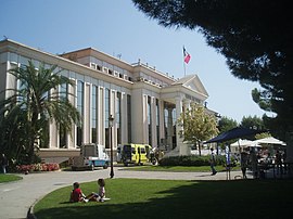
Saint-Laurent-du-Var
This article may be expanded with text translated from the corresponding article in French. (December 2008) Click [show] for important translation instructions.
|
Saint-Laurent-du-Var | |
|---|---|
Commune | |
 Town hall | |
 Coat of arms | |
Location of Saint-Laurent-du-Var | |
 Saint-Laurent-du-Var Show map of France  Saint-Laurent-du-Var Show map of Provence-Alpes-Côte d'Azur | |
| Coordinates: 43°40′05″N 7°11′17″E / 43.668°N 7.188°E / 43.668; 7.188Coordinates: 43°40′05″N 7°11′17″E / 43.668°N 7.188°E / 43.668; 7.188 | |
| Country | France |
| Region | Provence-Alpes-Côte d'Azur |
| Department | Alpes-Maritimes |
| Arrondissement | Grasse |
| Canton | Cagnes-sur-Mer-2 |
| Intercommunality | Métropole Nice Côte d'Azur |
| Government | |
| • Mayor .mw-parser-output .nobold{font-weight:normal} (2008–2014) | Henri Revel |
| Area 1 | 10.11 km2 (3.90 sq mi) |
| Population (2012)2 | 29,343 |
| • Density | 2,900/km2 (7,500/sq mi) |
| Time zone | UTC+01:00 (CET) |
| • Summer (DST) | UTC+02:00 (CEST) |
INSEE/Postal code | 06123 /06700 |
| Elevation | 0–214 m (0–702 ft) (avg. 17 m or 56 ft) |
1 French Land Register data, which excludes lakes, ponds, glaciers > 1 km2 (0.386 sq mi or 247 acres) and river estuaries. 2Population without double counting: residents of multiple communes (e.g., students and military personnel) only counted once. | |
Saint-Laurent-du-Var is a commune in the Alpes-Maritimes department in the Provence-Alpes-Côte d'Azur region on the French Riviera.
Contents
1 History
2 Geography
3 Demographics
4 Transportation
5 Twin towns
6 See also
7 References
8 External links
History
The town was founded in the 11th century when a hospice was founded under Saint Lawrence's protection. The main activity was to help passengers to cross the Var, which became a border between Kingdom of France and County of Nice in 1481.
Geography
St. Laurent is the second-largest suburb of the city of Nice, after Cagnes-sur-Mer, in the urban community of Nice Côte d'Azur. It lies adjacent to it on the west side on the other side of the river Var.
Nowadays, the town has developed much and its population has been multiplied by ten in the last century and it is now part of Nice metropolitan area.
The suburb's positioning, close to Nice and with an abundance of flatlands - which is a rare resource in this region - led to the building of CAP 3000, the Côte d'Azur's biggest mall, and an industrial zone with many dynamic activities.
Demographics
| Historical population | ||
|---|---|---|
| Year | Pop. | ±% |
| 1962 | 8,186 | — |
| 1968 | 10,156 | +24.1% |
| 1975 | 15,503 | +52.6% |
| 1982 | 20,678 | +33.4% |
| 1990 | 24,426 | +18.1% |
| 1999 | 27,141 | +11.1% |
| 2008 | 30,276 | +11.6% |
Transportation
St. Laurent is located close to "Nice Côte d'Azur" Airport, in the eastern side of Var river, Nice. The town also has a harbour, an interchange on the motorway A8 and a railway station on the Marseille-Toulon-Nice-Ventimiglia line.
Twin towns
Saint-Laurent-du-Var is twinned with:
 Landsberg am Lech (Germany)
 Siófok (Hungary)
 Waldheim (Germany)
 all the French towns named "Saint-Laurent" (95 in Metropolitan France)
 Saint-Laurent-du-Maroni (French Guiana)
See also
- Nice metropolitan area
- Urban community of Nice Côte d'Azur
- Communes of the Alpes-Maritimes department
References
- INSEE
External links
| Wikimedia Commons has media related to Saint-Laurent-du-Var. |
- Official website of St.Laurent du Var
- CAP 3000 website (in French)

Comments
Post a Comment