 Mixing
Murwillumbah
Murwillumbah New South Wales | |||||||||||||||
|---|---|---|---|---|---|---|---|---|---|---|---|---|---|---|---|
 Partial view of town and Tweed River, 2008 | |||||||||||||||
 Murwillumbah | |||||||||||||||
| Coordinates | 28°19′39″S 153°23′45″E / 28.32750°S 153.39583°E / -28.32750; 153.39583Coordinates: 28°19′39″S 153°23′45″E / 28.32750°S 153.39583°E / -28.32750; 153.39583 | ||||||||||||||
| Population | 9,245 (2016 census)[1] | ||||||||||||||
| Postcode(s) | 2484 | ||||||||||||||
| Elevation | 8 m (26 ft) | ||||||||||||||
| Location |
| ||||||||||||||
| LGA(s) | Tweed Shire | ||||||||||||||
| County | Rous | ||||||||||||||
| State electorate(s) | Lismore | ||||||||||||||
| Federal Division(s) | Richmond | ||||||||||||||
| |||||||||||||||
| |||||||||||||||
Murwillumbah is a town in far north-eastern New South Wales, Australia, in the Tweed Shire, on the Tweed River, 848 km north-east of Sydney, 13 km south of the Queensland border and 132 km south of Brisbane. At the 2016 census, Murwillumbah had a population of 9,245 people.[1] The town's name is often abbreviated to M'bah[2] or Murbah.[3]
Murwillumbah sits on the south eastern foothills of the McPherson Range in the Tweed Volcano valley. The area is hilly. Many of the buildings are Art Deco in style and there are cafes, clothes and antique shops in the town. Murwillumbah is the eighth town mentioned in the original Australia version of the song "I've Been Everywhere".
Murwillumbah was used as the location for the film Lou (2010) starring John Hurt. The ABC television series of the novel Pastures of the Blue Crane was also filmed in the Tweed region in 1969.[4]
It is also the home of the Tweed Regional Gallery.
Contents
1 History
1.1 Floods
1.2 Heritage listings
2 Transport
3 Industry
4 Festivals
5 Demographics
6 Education
7 Sport and recreation
8 Notable people
9 Gallery
10 References
11 External links
History

Main street, c. 1905
The first people to live in the area were Kalibai people. The name Murwillumbah may derive from an Aboriginal compound meaning either "camping place" – from murrie, meaning "aboriginal people", wolli, "a camp", and bah, "place", or, alternatively from murra "big" ,willum "opossum" and bah (place).[5] Nearby Mount Warning and its attendant national park are known as Wollumbin, meaning "Cloud Catcher", in the Bundjalung language.
Timber-getters were drawn to the region in the 1840s.[6] The river port at Tumbulgum was initially the main settlement. In 1902, a local government municipality was declared with Murwillumbah as its centre.[6]
Most of the town's business district was destroyed by fire in 1907.[7] Murwillumbah is the location for Australia’s largest-ever bank robbery which occurred in 1978 and has not been solved.[7]
Floods
Murwillumbah is protected by a series of levees,[8] but they do not protect all parts of the town in major floods. The worst flood to affect the town occurred on 30 March 2017 when the Tweed River reached 6.2 metres (20 ft) after rainfall of over 700 millimetres (28 in) from the remnants of Tropical Cyclone Debbie fell in its upper catchment over a 36 hour period. This level caused extensive flooding and mass evacuations in South Murwillumbah and other low-lying areas, cut road access from the north and south, and fell just short of overtopping the 6.3 metres (21 ft) levees protecting the central business district.[citation needed]
The event exceeded previous major floods in 1954[8] and 1956.[7]
In March 1974, two hundred people were evacuated from the town after floodwater from Tropical Cyclone Zoe inundated the area.[9] In January 2008, Murwillumbah and surrounding areas were hit by severe flooding.[10] May 2009 saw more evacuations in the town and surrounds after heavy rainfall.[11]
Heritage listings
Murwillumbah has a number of heritage-listed sites, including:
- Casino-Murwillumbah railway, South Murwillumbah: Murwillumbah railway station[12]
Transport
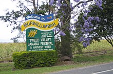
Murwillumbah sign
The town was bypassed by the Pacific Highway in August 2002. Today, main road access from both north and south is via the scenic Tweed Valley Way, which was formerly a section of the original highway.
There is an inland road that passes along the Numinbah Valley through the towns of Chillingham, Numinbah and Natural Bridge which is scenic tourist drive. Another major road west of the town heads to Kyogle via the town Uki, and also passes near the town of Nimbin.
Murwillumbah station was the terminus of the Casino–Murwillumbah branch line, and had daily train services to Sydney until the line closed in 2004. Today NSW TrainLink coaches to and from Casino provide connections to daily trains to Sydney.
Several bus services serve the area. Murwillumbah Bus Company offers regular services to major parts of the town, as well as Condong and Uki. Parson's Bus Service offers services to Pottsville, Cabarita Beach, and Stokers Siding. Gosel's Bus Service offers services to Nimbin via Uki on route 630. Singh's Bus Service offers services to Chillingham, Tyalgum and Eungella. Surfside Buslines operate hourly service to Tweed Heads via Terranora on route 605.
Taxi services are also available.
Murwillumbah's airfield, Whittle Field (ICAO code YMUR), is named after a noted local World War II Spitfire pilot, the late Bob Whittle.[citation needed] It has no scheduled services, but its 800-metre grass runway supports Murwillumbah Aero Club and business activities including crop-dusting, aircraft restoration, training and scenic charter flights.
Industry
The major industry of the area, apart from tourism, is sugarcane growing. There were numerous tramways in the area serving the sugar mill at Condong until 1973 with the introduction of mechanical cane harvesting.[13] There is also some dairy farming in the area. Coffee, bananas and assorted tropical fruit and vegetables are also produced throughout the valley. Murwillumbah is also home to Stone & Wood Brewing Co.'s second brewery, which opened in 2014. There are alternative lifestyle retreats nearby, notably one belonging to the Hare Krishna religion.
Festivals
The annual Tweed Banana Festival, the second oldest festival in Australia is staged in the town. In 2005, the festival celebrated its 50th anniversary.[14]
From 2002 to 2009 an historic motor racing festival was run through the streets of Murwillimbah, featuring a parade through town, a one kilometre hillclimb course, and connected events, attracting thousands of spectators. Modeled on the Goodwood Festival of Speed, Speed on Tweed was a highlight of the local calendar attracting cars and competitors from all over Australia and from Europe and North America. In September 2009 the event was held in conjunction with Rally Australia which has scheduled one special stage in Murwillumbah.
Demographics
In the 2016 census, Murwillumbah recorded a population of 9,245 people, 52.5% female and 47.5% male. The median age of the Murwillumbah population was 45 years, 7 years above the national median of 38.
81.1% of people living in Murwillumbah were born in Australia. The other top responses for country of birth were England 3.4%, New Zealand 1.9%, India 0.8%, Scotland 0.4%, and Philippines 0.4%. 89.2% of people spoke only English at home; the next most common languages were Punjabi 1.2%, Spanish 0.3%, Italian 0.3%, Tagalog 0.2%, and German 0.2%.[1]
Education
Primary schools
- Hare Krishna School
- Mt St Patrick Primary School
- Murwillumbah East Primary School
- Sathya Sai School
- South Murwillumbah's Infants School
- St Joseph's Primary School
- Murwillumbah Primary School
- Tweed Valley Adventist College
Secondary schools
- Hare Krishna School
- Mount Saint Patrick College
- Murwillumbah High School
- Sathya Sai School
- Wollumbin High School
- Tweed Valley Adventist College
Sport and recreation
Murwillumbah has numerous sports clubs including Murwillumbah Mustangs, Murwillumbah SC, The Gentlemen of Murwillumbah Rugby Club, golf, rowing, cricket, lawn bowls and cycling.
Notable people
Notable people from Murwillumbah include:
Doug Anthony (born 1929), Australian politician
Reginald Arnold (1924–2017), Australian cyclist
Larry Corowa (born 1957), Australian international rugby league player
Bob Downe (born 1966), stage persona of the comedian Mark Trevorrow[15]
Nathan Eglington (born 1980), Australian field hockey midfielder and striker
Stephanie Gilmore (born 1988), Australian surfer with six world titles
Robert Hagan (born 1947), Australian artist
John Hargreaves (1945-1996), Australian actor
Chris Higgins (1943–1990), senior Australian public servant
Anthony Laffranchi (born 1980), Australian National Rugby League player
Jenny McAllister, Australian politician
Tallulah Morton (born 1991), Australian model
Barry Singh (born 1965), Australian musician
Ann Symonds (born 1939), Australian politician
Johno Johnson (born 1930), Australian politician
Dylan Wotherspoon (born 1993), Australian International Field Hockey player
Max Bryant (born 1999), Brisbane Heat & Queensland Cricketer[16]
Gallery

View of Mount Warning
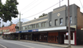
Main Street

Abandoned train lines
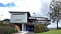
Nearby Tweed Regional Gallery


References
^ abc Australian Bureau of Statistics (27 June 2017). "Murwillumbah (Urban Centre/Locality)". 2016 Census QuickStats. Retrieved 25 November 2017.
^ "M'bah rail too costly: report" by Saffron Howden, Tweed Daily News (18 April 2009)
^ "Crittle set to tackle Murbah" by Jamie Gallagher and Geoff Campbell, Tweed Daily News (15 December 2009)
^ Pastures of the Blue Crane on IMDb
^ J. S. Ryan, 'Some Aboriginal Place-Names in the Richmond Tweed Area,' Oceania September 1963, volume 34, no. 1, pages = 38-55, p.42
^ ab "About the Tweed: History". Tweed Shire Council. Retrieved 20 April 2011..mw-parser-output cite.citation{font-style:inherit}.mw-parser-output .citation q{quotes:"""""""'""'"}.mw-parser-output .citation .cs1-lock-free a{background:url("//upload.wikimedia.org/wikipedia/commons/thumb/6/65/Lock-green.svg/9px-Lock-green.svg.png")no-repeat;background-position:right .1em center}.mw-parser-output .citation .cs1-lock-limited a,.mw-parser-output .citation .cs1-lock-registration a{background:url("//upload.wikimedia.org/wikipedia/commons/thumb/d/d6/Lock-gray-alt-2.svg/9px-Lock-gray-alt-2.svg.png")no-repeat;background-position:right .1em center}.mw-parser-output .citation .cs1-lock-subscription a{background:url("//upload.wikimedia.org/wikipedia/commons/thumb/a/aa/Lock-red-alt-2.svg/9px-Lock-red-alt-2.svg.png")no-repeat;background-position:right .1em center}.mw-parser-output .cs1-subscription,.mw-parser-output .cs1-registration{color:#555}.mw-parser-output .cs1-subscription span,.mw-parser-output .cs1-registration span{border-bottom:1px dotted;cursor:help}.mw-parser-output .cs1-ws-icon a{background:url("//upload.wikimedia.org/wikipedia/commons/thumb/4/4c/Wikisource-logo.svg/12px-Wikisource-logo.svg.png")no-repeat;background-position:right .1em center}.mw-parser-output code.cs1-code{color:inherit;background:inherit;border:inherit;padding:inherit}.mw-parser-output .cs1-hidden-error{display:none;font-size:100%}.mw-parser-output .cs1-visible-error{font-size:100%}.mw-parser-output .cs1-maint{display:none;color:#33aa33;margin-left:0.3em}.mw-parser-output .cs1-subscription,.mw-parser-output .cs1-registration,.mw-parser-output .cs1-format{font-size:95%}.mw-parser-output .cs1-kern-left,.mw-parser-output .cs1-kern-wl-left{padding-left:0.2em}.mw-parser-output .cs1-kern-right,.mw-parser-output .cs1-kern-wl-right{padding-right:0.2em}
^ abc "Murwillumbah: A Brief History". Murwillumbah Chamber of Commerce:. Retrieved 20 April 2011.
^ ab "Flood Plan". Murwillumbah Chamber of Commerce. Retrieved 20 April 2011.
^ "Historical Tropical Cyclone Impacts in New South Wales". Bureau of Meteorology. Retrieved 20 April 2011.
^ "Remembering Murwillumbah floods". Tweed Daily News. The Tweed Newspaper Company. 6 January 2010. Retrieved 20 April 2011.
^ Kristy Martin (21 May 2009). "Mass evacuations forced in Tweed". Tweed Daily News. The Tweed Newspaper Company. Retrieved 20 April 2011.
^ "Murwillumbah Railway Station and yard group". New South Wales State Heritage Register. Office of Environment and Heritage. H01206. Retrieved 18 May 2018.
^ "The Sugar Tramways of Northern New South Wales", Armstrong, J., Australian Railway Historical Society Bulletin, June, 1976, pp. 118–132
^ "Banana Festival under way". Tweed Daily News. The Tweed Newspaper Company. 20 August 2005. Retrieved 20 April 2011.
^ "The one story the English actually give a rat’s about" by Amy Fallon, The Punch (10 December 2009)
^ http://www.espncricinfo.com/australia/content/player/1088608.html
External links
 Media related to Murwillumbah at Wikimedia Commons
"Murwillumbah (Bray Park)". Climate statistics for Australian locations. Bureau of Meteorology. Retrieved 13 April 2010.


Comments
Post a Comment