 Mixing
Sremski Karlovci
Sremski Karlovci Сремски Карловци | ||
|---|---|---|
Town and municipality | ||
 Sremski Karlovci panoramic view | ||
| ||
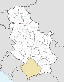 Location of the municipality of Sremski Karlovci within Serbia | ||
| Coordinates: 45°12′N 19°56′E / 45.200°N 19.933°E / 45.200; 19.933Coordinates: 45°12′N 19°56′E / 45.200°N 19.933°E / 45.200; 19.933 | ||
| Country | ||
| Province | Vojvodina | |
| District | South Bačka | |
| Settlements | 1 | |
| Government | ||
| • Mayor | Nenad Milenković (SNS) | |
| Area [1] | ||
| • Municipality | 51 km2 (20 sq mi) | |
| Elevation | 87 m (285 ft) | |
| Population (2011 census)[2] | ||
| • Town | 8,750 | |
| • Town density | 170/km2 (440/sq mi) | |
| • Municipality | 8,750 | |
| Time zone | UTC+1 (CET) | |
| • Summer (DST) | UTC+2 (CEST) | |
| Postal code | 21205 | |
| Area code | +381(0)21 | |
| Car plates | NS | |
| Website | sremskikarlovci.rs | |

Sremski Karlovci (Serbian Cyrillic: Сремски Карловци, pronounced [srêːmskiː kâːrloːʋt͡si], Croatian: Srijemski Karlovci) is a town and municipality located in the South Bačka District of the autonomous province of Vojvodina, Serbia. It is situated on the bank of the river Danube, 8 kilometres (5 miles) from Novi Sad. According to the 2011 census results, it has a population of 8,750 inhabitants. The town has traditionally been known as the seat of the Serbian Orthodox Church in the Habsburg Monarchy, as well as political and cultural capital of Serbian Vojvodina after the May Assembly and during the Revolution in 1848.
Contents
1 Name
2 Geography
3 History
3.1 Ancient, medieval and early modern history
3.2 Habsburg Monarchy
3.3 Yugoslavia (1918–92)
4 Demographics
4.1 Ethnic groups
5 Politics
6 Schools
7 Buildings and structures
8 International relations
8.1 Twin towns – Sister cities
9 Gallery
10 See also
11 Literature
12 References
13 External links
Name
In Serbian, the town is known as Sremski Karlovci (Сремски Карловци), in Croatian as Srijemski Karlovci, in German as Karlowitz or Carlowitz, in Hungarian as Karlóca, in Polish as Karłowice, in Romanian as Carloviț and in Turkish as Karlofça. The former Serbian name used for the town was Karlovci (Карловци) which is also used today, albeit unofficially.
Geography
The town is situated in the geographical region of Syrmia. The town of Sremski Karlovci is the only settlement in the municipality.
History
Ancient, medieval and early modern history
In ancient times, a small Roman fortress existed at this location. The town was first mentioned in historical documents in 1308 with the name Karom. The fortress of Karom was built on the ruins of the ancient Roman one. Until 1521, the Karom was a possession of the Hungarian noble families, of which the most well known were Báthory and Morović.
Turkish military commander Bali-beg conquered Karom in 1521, and in the next 170 years, the town was part of the Ottoman Empire. The Slavic name for the town - Karlovci, was first recorded in 1532/33. During the Ottoman rule, the town was mostly populated by Serbs, with the smaller part of population composed of Muslims. According to the Ottoman defterler from 1545,[citation needed] the population of Karlovci numbered 547 Christian (Serb) houses. The city also had three Orthodox churches and a monastery. From 1557, it belonged to Eparchy of Belgrade and Srem of the Serbian Patriarchate of Peć.
Habsburg Monarchy
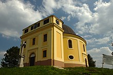
Kapela mira (Peace Chapel), erected on the spot where the Treaty of Karlowitz was negotiated. Its shape reminds of the tent in which the negotiations took place
Between 16 November 1698 and 26 January 1699, the town of Karlovci was the site of a congress that ended the hostilities between the Ottoman Empire and the Holy League, a coalition of various European powers including Habsburg Monarchy, Poland, Venice and Russia; the congress produced the Treaty of Karlowitz. It was the first time a round table was used in international politics.
After this peace treaty, the town was part of the Habsburg Monarchy and was included into the Military Frontier. According to the 1702 data, the population of the town was composed of 215 Orthodox and 13 Catholic houses, while according to the 1753 data, the population of the town numbered 3,843 people, of which 3,110 were ethnic Serbs.
The town was also the spiritual, political and cultural center of the Serbs in the Habsburg Monarchy. The Metropolitan of the Serbian Orthodox Church resided in the town. Even now, the Serbian Patriarch retains the title of Metropolitan of Karlovci.
The town also featured the earliest Serb (and Slavic in general) gymnasium (Serbian: gimnazija/гимназија, French: lycée) founded on 3 August 1791. Three years after this, an Orthodox seminary was also founded in the town: it was the second oldest Orthodox seminary in the world (after the Spiritual Academy in Kiev), and it is still in existence.
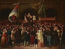
Proclamation of Serbian Vojvodina in 1848 in Sremski Karlovci
At the Serb National Assembly in Karlovci in May 1848, Serbs declared the unification of the regions of Srem, Banat, Bačka, and Baranja (including parts of the Military Frontier) into the province of Serbian Vojvodina.
The first capital of Serbian Vojvodina was in Karlovci, until it was latter moved to Zemun, Veliki Bečkerek, and Temišvar. At the same time the title of the Orthodox Metropolitan of Karlovci was raised to that of Patriarch, which thus established an Orthodox Patriarchate of Karlovci that existed until 1920 when it was joined with the Metropolitanate of Belgrade to form the united Serbian Orthodox Church.
When Serbian Vojvodina was in 1849 transformed into the new province named Voivodeship of Serbia and Banat of Temeschwar, town of Karlovci was not included into this province, but was returned under the administration of the Military Frontier (Petrovaradin regiment that was part of Slavonian Krajina). With the abolishment of the Military Frontier in 1881, the town was included into Syrmia County of Croatia-Slavonia, the autonomous kingdom within Kingdom of Hungary and Austria-Hungary.
Yugoslavia (1918–92)

Fountain "Four Lions" in the Center of Sremski Karlovci
In 1918, the town became part of the Kingdom of Serbs, Croats and Slovenes. In the summer of 1921, the town′s former palace of the Patriarch of Karlovci became home to Russian metropolitan Antony (Khrapovitsky), who organised what a few years later was instituted as the Holy Synod of the Russian Orthodox Church Outside Russia. (Critics labeled this ecclesiastical body Karlovatsky Synod (Russian: Карловацкий синод), or ″Karlovatsky group″, also known in English as Synod of Karlovci[3].)
In 1922, the town also became the headquarters of Russian White émigrés under the leadership of General Wrangel, where in 1924 he set up the Russian All-Military Union designed to embrace all Russian military émigrés the world over[4] (a monument to Gen Wrangel, sculpted by Vasiliy Azemsha, was unveiled in September 2007[5]).
Between 1929 and 1941, the town was part of Danube Banovina, a province of the Kingdom of Yugoslavia. During World War 2 (1941–1944), the town was occupied by the Axis Powers and it was attached to the Independent State of Croatia. During that time its name was changed to Hrvatski Karlovci. Since the end of the war, the town has been part of the Autonomous Province of Vojvodina.
Between 1980 and 1989, Sremski Karlovci was one of the seven municipalities of the city of Novi Sad.
Demographics
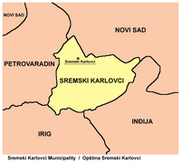
Map of Sremski Karlovci municipality
| Historical population | ||
|---|---|---|
| Year | Pop. | ±% |
| 1948 | 5,350 | — |
| 1953 | 5,618 | +5.0% |
| 1961 | 6,390 | +13.7% |
| 1971 | 7,040 | +10.2% |
| 1981 | 7,547 | +7.2% |
| 1991 | 7,534 | −0.2% |
| 2002 | 8,839 | +17.3% |
| 2011 | 8,750 | −1.0% |
| Source: [6] | ||
According to the 2011 census results, the municipality of Sremski Karlovci has 8,750 inhabitants.
Ethnic groups
Ethnic composition of the municipality of Sremski Karlovci:[7]
| Ethnic group | Population |
|---|---|
| Serbs | 6,820 |
| Croats | 576 |
| Hungarians | 182 |
| Yugoslavs | 71 |
| Germans | 63 |
| Montenegrins | 41 |
| Slovaks | 29 |
| Macedonians | 25 |
| Rusyns | 16 |
| Slovenes | 15 |
| Romani | 14 |
| Russians | 11 |
| Others | 969 |
| Total | 8,750 |
Politics
Until 1989 Sremski Karlovci formed one of the urban municipalities of the city of Novi Sad. After Novi Sad merged six of its municipalities into one Novi Sad municipality, the municipality of Sremski Karlovci held a referendum to separate from Novi Sad, and established a separate municipality independent from Novi Sad. Although Sremski Karlovci lies in Syrmia region, the municipality belongs in South Bačka District, and not in the Syrmia District, because of its close proximity to Novi Sad.
In the Serbian local elections held on 24 April 2016, Sremski Karlovci elected a new municipality parliament, ending the rule of the DS in the town. Nenad Milenković, of the Serbian progressive Party, was elected as the new mayor of the municipal parliament.
Schools
- Gymnasium of Karlovci
- Clerical High School of Saint Arsenije
Buildings and structures
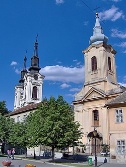
Orthodox and Catholic churches in Sremski Karlovci

Fountain "Four Lions" after reconstruction
- Educational historical buildings:
Gymnasium of Karlovci, first Serbian secondary school (gymnasium)- Clerical High School of Saint Arsenije
- Administrative buildings:
- Sremski Karlovci City Hall
- Religious buildings
- The Patriarchal Court
- The Orthodox cathedral of Saint Nikolaj
- The Roman Catholic Church of the Holy Trinity
- Other buildings
- Fountain "Four Lions"
- The Chapel of Peace, Sremski Karlovci
International relations
Twin towns – Sister cities
Sremski Karlovci is twinned with:
|
|
Gallery

Gymnasium of Karlovci

The Orthodox Cathedral of St. Nicholas

Clerical High School of Saint Arsenije

Down Church

Museum of Karlovci

Viewpoint of Karlovci


See also
- Fruška Gora
- Syrmia
- List of places in Serbia
- List of cities, towns and villages in Vojvodina
- Spatial Cultural-Historical Units of Exceptional Importance
Literature
- Milorad Grujić, Vodič kroz Novi Sad i okolinu, Novi Sad, 2004.
- Slobodan Ćurčić, Broj stanovnika Vojvodine, Novi Sad, 1996.
References
^ "Municipalities of Serbia, 2006". Statistical Office of Serbia. Retrieved 2010-11-28..mw-parser-output cite.citation{font-style:inherit}.mw-parser-output .citation q{quotes:"""""""'""'"}.mw-parser-output .citation .cs1-lock-free a{background:url("//upload.wikimedia.org/wikipedia/commons/thumb/6/65/Lock-green.svg/9px-Lock-green.svg.png")no-repeat;background-position:right .1em center}.mw-parser-output .citation .cs1-lock-limited a,.mw-parser-output .citation .cs1-lock-registration a{background:url("//upload.wikimedia.org/wikipedia/commons/thumb/d/d6/Lock-gray-alt-2.svg/9px-Lock-gray-alt-2.svg.png")no-repeat;background-position:right .1em center}.mw-parser-output .citation .cs1-lock-subscription a{background:url("//upload.wikimedia.org/wikipedia/commons/thumb/a/aa/Lock-red-alt-2.svg/9px-Lock-red-alt-2.svg.png")no-repeat;background-position:right .1em center}.mw-parser-output .cs1-subscription,.mw-parser-output .cs1-registration{color:#555}.mw-parser-output .cs1-subscription span,.mw-parser-output .cs1-registration span{border-bottom:1px dotted;cursor:help}.mw-parser-output .cs1-ws-icon a{background:url("//upload.wikimedia.org/wikipedia/commons/thumb/4/4c/Wikisource-logo.svg/12px-Wikisource-logo.svg.png")no-repeat;background-position:right .1em center}.mw-parser-output code.cs1-code{color:inherit;background:inherit;border:inherit;padding:inherit}.mw-parser-output .cs1-hidden-error{display:none;font-size:100%}.mw-parser-output .cs1-visible-error{font-size:100%}.mw-parser-output .cs1-maint{display:none;color:#33aa33;margin-left:0.3em}.mw-parser-output .cs1-subscription,.mw-parser-output .cs1-registration,.mw-parser-output .cs1-format{font-size:95%}.mw-parser-output .cs1-kern-left,.mw-parser-output .cs1-kern-wl-left{padding-left:0.2em}.mw-parser-output .cs1-kern-right,.mw-parser-output .cs1-kern-wl-right{padding-right:0.2em}
^ "2011 Census of Population, Households and Dwellings in the Republic of Serbia: Comparative Overview of the Number of Population in 1948, 1953, 1961, 1971, 1981, 1991, 2002 and 2011, Data by settlements" (PDF). Statistical Office of Republic Of Serbia, Belgrade. 2014. ISBN 978-86-6161-109-4. Retrieved 2014-06-27.
^ Synod of Karlovci Britannica
^ Wrangel, Petr Nikolaevich, Baron
^ Споменик белом барону Politika, 13 September 2007.
^ "2011 Census of Population, Households and Dwellings in the Republic of Serbia" (PDF). stat.gov.rs. Statistical Office of the Republic of Serbia. Retrieved 16 January 2017.
^ "Попис становништва, домаћинстава и станова 2011. у Републици Србији" (PDF). stat.gov.rs. Republički zavod za statistiku. Retrieved 16 January 2017.
^ "National Commission for Decentralised cooperation". Délégation pour l’Action Extérieure des Collectivités Territoriales (Ministère des Affaires étrangères) (in French). Archived from the original on 2013-11-27. Retrieved 2013-12-26.
External links
| Wikimedia Commons has media related to Sremski Karlovci. |
| Wikivoyage has a travel guide for Sremski Karlovci. |
 . Encyclopædia Britannica (11th ed.). 1911.
- Official website
Municipalities and cities of Serbia | ||||||||||||
|---|---|---|---|---|---|---|---|---|---|---|---|---|
| ||||||||||||
| ||||||||||||
| ||||||||||||
| ||||||||||||
| ||||||||||||


Authority control |
|
|---|


Comments
Post a Comment