 Mixing
El Pardo
El Pardo | |
|---|---|
Ward of Madrid | |
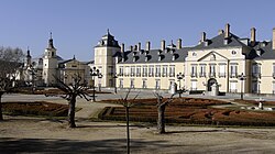 The Royal Palace of El Pardo | |
 | |
| Country | |
| Aut. community | |
| Municipality | |
| District | |
| Elevation |
685 m (2,247 ft) |
| Population |
3,657 |
| Demonym(s) | Pardeño, Pardeña |
El Pardo is a ward (barrio) of Madrid belonging to the district of Fuencarral-El Pardo. As of 2008 its population was of 3,656.[1]
Contents
1 History
2 Geography
3 Photogallery
4 References
5 External links
History
The ward was first mentioned in 1405 and in 1950 was an autonomous municipality of the Community of Madrid. One of the most notable buildings is the "Royal Palace of El Pardo", built in 1406 by the order of King Henry III of Castile. It was the first large edifice built in the area.[2]
The Palace of El Pardo was the residence of General Franco when he was head of the Spanish State.
Geography
El Pardo is located in the northern suburb of Madrid, close to the Manzanares river. Part of its area is covered by a forest named Monte de El Pardo (El Pardo Mountain). The ward contains a neighbourhood called Mingorrubio.
Photogallery

The Manzanares at Monte de El Pardo
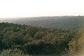
Panoramic view of the Monte de El Pardo
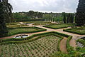
The gardens of the Quinta del Duque del Arco


References
^ (in Spanish) 2008 Population statistics of Madrid (xls)
^ (in Spanish) Infos about the Royal Palace on www.patrimonionacional.es Archived January 14, 2013, at the Wayback Machine
External links
| Wikimedia Commons has media related to El Pardo. |
(in Spanish) Bibliography about El Pardo
Districts and wards of Madrid | ||
|---|---|---|
| Arganzuela |
|
|
| Barajas |
|
|
| Carabanchel |
|
|
| Centro |
|
|
| Chamartín |
|
|
| Chamberí |
|
|
| Ciudad Lineal |
|
|
| Fuencarral-El Pardo |
|
|
| Hortaleza |
|
|
| Latina |
|
|
| Moncloa-Aravaca |
|
|
| Moratalaz |
|
|
| Puente de Vallecas |
|
|
| Retiro |
|
|
| Salamanca |
|
|
| San Blas-Canillejas |
|
|
| Tetuán |
|
|
| Usera |
|
|
| Vicálvaro |
|
|
| Villa de Vallecas |
|
|
| Villaverde |
|
|
Coordinates: 40°31′N 3°46′W / 40.517°N 3.767°W / 40.517; -3.767


Comments
Post a Comment