 Mixing
特倫特河
特倫特河 River Trent | |
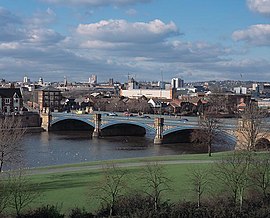 特倫特橋,背後是諾丁漢 | |
名称起源:Trisantona | |
| 国家 |
英國 |
|---|---|
| 构成国 |
英格蘭 |
| 郡 |
斯塔福德郡、德比郡、萊斯特郡、諾丁漢郡、林肯郡、東約克郡 |
| 市 |
特倫特河潘斯托克、德比、諾丁漢 |
| 鎮 |
斯通、特倫特河畔柏頓、特倫特河畔紐瓦克、根斯堡 |
支流 | |
| - 左侧支流 |
布萊茲河、斯瓦本河、達夫河、德文特河、埃里沃什河、利恩河、格里特河、艾德河、托爾河 |
| - 右侧支流 |
索烏河、塔梅河、米斯河、索爾河、德文河、歐河 |
| 源头 |
|
| - 位置 |
英格蘭斯塔福德郡比達爾夫沼澤 |
| - 海拔 |
275 m(902 ft) |
| - 坐标 |
53°07′05″N 2°08′36″W / 53.118011°N 2.14332°W / 53.118011; -2.14332 |
| 河口 |
|
| - 位置 |
英格蘭林肯郡 & 東約克郡亨伯河河口 |
| - 海拔 |
0 m(0 ft) |
| - 坐标 |
53°42′03″N 0°41′28″W / 53.700833°N 0.691111°W / 53.700833; -0.691111 |
| 长度 |
298 km(185 mi) |
| 流域面积 |
10,435 km²(4,029 mi²)[1][a] |
| 流量 |
考爾維克 |
| - 平均流量 |
84 m³/s(2,966 ft³/s)[3] |
| - 最大流量 |
1,018 m³/s(35,950 ft³/s)[4][b] |
| - 最小流量 |
15 m³/s(530 ft³/s)[3][c] |
其他地点流量(平均值) | |
| - 北馬斯克赫姆 |
88 m³/s(3,108 ft³/s) |
 特倫特河流域 | |
维基共享资源:River Trent | |
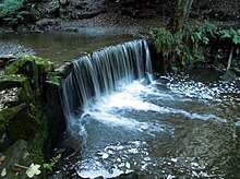
特伦特河源头下游的一个人工瀑布
特倫特河(River Trent)是英格蘭的主要河流之一,發源於比達爾夫沼澤南部的斯塔福德郡地區,流經英格蘭中部地區,與烏茲河匯流形成亨伯河,最終在赫爾河畔京士頓和伊明赫姆間注入北海。
特倫特河因為後半段向北流淌而與英格蘭其他諸河大為不同,它還有著被稱為“特倫特埃吉爾”(Trent Aegir)的潮津波。此外,特倫特河是英格蘭中北部地區的主要灌溉河流。
目录
1 名稱
2 歷史
2.1 改道
3 註釋
4 參考文獻
5 外部連結
名稱
“Trent”一名來自凱爾特語,是由兩個凱爾特語詞tros(越過)和 hynt(道路)合成的。[5] 較為可信的解釋是因為特倫特河的淺灘擋住了交通要道,這一說法同時也解釋了爲什麽特倫特河畔的城市名稱中(例如Hill Ridware)常見有rid(即“淺灘”)這一元素。也还可能是因为河流常常氾濫漫過道路而得名。而艾薩克·沃爾頓在《The Compleat Angler》(1653年)中寫到特倫特河被這麼稱呼是因為“其中發現了三十種魚”。
歷史
170萬年前的更新世時,特倫特河起源於威爾士的山嶺地帶,向東流過現在的貝爾沃谷,然後注入北海。[6] 在130,000年前冰川阻斷了貝爾沃谷的河道,特倫特河也因此該道向北偏移。在公元前七萬年的末次冰期冰川消退,在特倫特河下游形成了冰川湖,冰川湖消失之後如今特倫特河的河道就大致固定下來了。[7]
改道
同大多數英格蘭的河流不同,特倫特河在歷史上曾頻繁改道,其中尤以中游為明顯。[8]:192雷普頓有一條河道在舊地圖上標作“老特倫特”(Old Trent Water),這裡曾是特倫特的主要航道之一,然因為河流在18世紀向北移動而被廢棄。[8]:200 在下游的亨明頓考古學家還發現了中世紀的廢棄河道和橋樑。[9][10] 像這樣的古河道還有很多。[8][11]莎士比亞在《亨利四世第一部》中也提到了特倫特河改道的現象。[12][13][14]
註釋
^ 也有10,452 km2的說法。[2]
^ 2000年11月8日的記錄為1230hrs,這是自1958年9月1日以來的最大值。
^ 1976年8月23日至24日。
參考文獻
^ Trent River Authority. Official Handbook of the Trent River Authority. Cheltenham and London:Ed. J. Burrow and Co. Ltd, 1972.
^ Midlands Catchment Flood Management Plans. Environment Agency. [11 April 2013].
^ 3.03.1 28009 – Trent at Colwick. The National River Flow Archive. Centre for Ecology & Hydrology. [24 March 2013].
^ Hi Flows UK. Environment-agency.gov.uk. [4 March 2013].
^ University of Wales Online Dictionary
^ Posnansky, M. The Pleistocene Succession in the Middle Trent Basin. Proc. Geologists' Assoc 71 (1960), pp.285–311
^ May 1977.
^ 8.08.18.2 Historical channel-floodplain dynamics along the River Trent (PDF). Hislibrary.com. [24 March 2013]. (原始内容 (PDF)存档于2013年11月5日).
^ Keys, David. Medieval Timber Bridge Unearthed. London: The Independent. 22 November 1993 [24 March 2013].
^ Ripper, S. and Cooper L.P., 2009, The Hemington Bridges: "The Excavation of Three Medieval Bridges at Hemington Quarry, Near Castle Donington, Leicestershire", Leicester Archaeology Monograph
^ The Trent Valley: palaeochannel mapping from aerial photographs (PDF). Trent Valley GeoArchaeology. [28 March 2013]. (原始内容 (PDF)存档于2013年11月5日).
^ William Shakespeare, Henry IV, Pt.I., Act III, Sc. I
^ Complete Works of William Shakespeare, William Shakespeare, p433, 2007, ISBN 1-84022-557-2, accessed May 2009
^ Everard Leaver Guilford. Memorials of old Nottinghamshire Memorials of old Nottinghamshire. London: G. Allen: 93–103. 1912 [11 May 2013].
外部連結
- Photographs along the Trent in Nottingham from Nottingham21
Catchment Tributaries of the River Trent English Heritage and University of Birmingham research project.
Predictive Modelling of Multi-Period Geoarchaeological Resources at a River Confluence English Heritage, University of Birmingham and University of Exeter research project.- Trent Valley GeoArchaeology
- River Trent through Nottingham. Pictures & slide show.


Comments
Post a Comment