 Mixing
Matelica
Matelica | ||
|---|---|---|
Comune | ||
| Comune di Matelica | ||
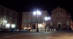 Piazza Enrico Mattei | ||
| ||
Location of Matelica | ||
 Matelica Location of Matelica in Italy Show map of Italy  Matelica Matelica (Marche) Show map of Marche | ||
| Coordinates: 43°15′23.71″N 13°0′34.54″E / 43.2565861°N 13.0095944°E / 43.2565861; 13.0095944Coordinates: 43°15′23.71″N 13°0′34.54″E / 43.2565861°N 13.0095944°E / 43.2565861; 13.0095944 | ||
| Country | Italy | |
| Region | Marche | |
| Province | Macerata (MC) |
|
| Frazioni | Balzani, Braccano, Castiglione, Cavalieri, Colferraio, Collepere, Colli, Grimaldi, Mistriano, Pezze, Piane, Poggeto, San Nicola, Terricoli, Valbona, Vinano |
|
| Government | ||
| • Mayor | Alessandro Delpriori | |
| Area [1] | ||
| • Total | 81.1 km2 (31.3 sq mi) | |
| Elevation |
354 m (1,161 ft) | |
| Population (2018-01-01)[2] | ||
| • Total | 9,665 | |
| • Density | 120/km2 (310/sq mi) | |
| Demonym(s) | Matelicesi | |
| Time zone | UTC+1 (CET) |
|
| • Summer (DST) | UTC+2 (CEST) |
|
| Postal code | 62024 |
|
| Dialing code | 0737 | |
| Patron saint | St. Adrian | |
| Saint day | 16 September | |
| Website | Official website | |

Matelica is a comune (municipality) of the Province of Macerata in the Italian region of Marche. Located about 60 kilometres (37 mi) southwest of Ancona and 35 kilometres (22 mi) west of Macerata, it extends over an area of 81.04 square kilometres (31.29 sq mi).
Contents
1 Geography
2 Climate
3 History
4 Main sights
5 Twin towns
6 References and notes
7 External links
Geography
Matelica lies in an ample valley where the Braccano creek joins the Esino river, dominated by the town from an eastern ravine. The valley, roughly in the north–south direction, is delimited on the east and west sides by Apennines sub-ranges, whose highest peaks are respectively Mount Gemmo at 719 metres (2,359 ft) and Mount San Vicino at 1,479 metres (4,852 ft), compared to the 354 metres (1,161 ft) above sea-level of the city centre.
Matelica borders on the following municipalities: Apiro, Castelraimondo, Cerreto d'Esi, Esanatoglia, Fabriano, Fiuminata, Gagliole, Poggio San Vicino, San Severino Marche.[3]
Climate
The climate is dictated by the Apennines and, to a lesser extent, by the temperate Adriatic Sea on the east. Consequently, Matelica enjoys a continental climate with cold winters and hot, dry summers. In winter, sub-zero temperatures and snowfall between December and February are common. Highest summer temperatures can be well above 30 °C (86 °F) in June and August. In keeping with the layout of the valley, the dominant winds are along the north–south direction, those from the south being more frequent but weaker than those from the north.
History
The first human settlements in the area can be traced to the Umbri and Picentes and date back to the 1st millennium BC. Later, under Roman rule, Matelica became a municipium (70 BC). Starting from the 5th century AD, it was seat of a bishop, who for a while remained the only authority, after the fall of the Western Roman Empire. The town was then annexed to the Byzantine Empire (552). Destroyed by the Lombards in 578, it was subsequently joined to the bishopric of Camerino.[4] From the 9th century, Matelica was under the indirect rule of the Holy Roman Empire (while belonging formally to the Papal States), then becoming a free municipality in 1160. In 1174, it was again obliterated, this time by the army of Christian I (Archbishop of Mainz). Since then, Matelica remained part of the Papal States (albeit at times under an independent Governor), until the Italian unification (1861), save for the brief Napoleonic occupation.
Main sights
The old part of town presents an urban structure dating largely from the Middle Ages, and is punctuated by several palazzi and churches from different periods.
Sights in the town include:
- Matelica Cathedral
Church of Sant'Agostino (14th century)
Church of San Francesco (1246-1260, façade from the 18th century)- Church of Santa Maria Maddalena
- Chiesa del Suffragio
- Communal palace
- Governor Palace and Civic Tower
- Piersanti Museum, housing a collection of artworks.
- Palazzo Pettinelli
Twin towns
 Las Rosas, Argentina
References and notes
^ "Superficie di Comuni Province e Regioni italiane al 9 ottobre 2011". Istat. Retrieved 16 March 2019..mw-parser-output cite.citation{font-style:inherit}.mw-parser-output .citation q{quotes:"""""""'""'"}.mw-parser-output .citation .cs1-lock-free a{background:url("//upload.wikimedia.org/wikipedia/commons/thumb/6/65/Lock-green.svg/9px-Lock-green.svg.png")no-repeat;background-position:right .1em center}.mw-parser-output .citation .cs1-lock-limited a,.mw-parser-output .citation .cs1-lock-registration a{background:url("//upload.wikimedia.org/wikipedia/commons/thumb/d/d6/Lock-gray-alt-2.svg/9px-Lock-gray-alt-2.svg.png")no-repeat;background-position:right .1em center}.mw-parser-output .citation .cs1-lock-subscription a{background:url("//upload.wikimedia.org/wikipedia/commons/thumb/a/aa/Lock-red-alt-2.svg/9px-Lock-red-alt-2.svg.png")no-repeat;background-position:right .1em center}.mw-parser-output .cs1-subscription,.mw-parser-output .cs1-registration{color:#555}.mw-parser-output .cs1-subscription span,.mw-parser-output .cs1-registration span{border-bottom:1px dotted;cursor:help}.mw-parser-output .cs1-ws-icon a{background:url("//upload.wikimedia.org/wikipedia/commons/thumb/4/4c/Wikisource-logo.svg/12px-Wikisource-logo.svg.png")no-repeat;background-position:right .1em center}.mw-parser-output code.cs1-code{color:inherit;background:inherit;border:inherit;padding:inherit}.mw-parser-output .cs1-hidden-error{display:none;font-size:100%}.mw-parser-output .cs1-visible-error{font-size:100%}.mw-parser-output .cs1-maint{display:none;color:#33aa33;margin-left:0.3em}.mw-parser-output .cs1-subscription,.mw-parser-output .cs1-registration,.mw-parser-output .cs1-format{font-size:95%}.mw-parser-output .cs1-kern-left,.mw-parser-output .cs1-kern-wl-left{padding-left:0.2em}.mw-parser-output .cs1-kern-right,.mw-parser-output .cs1-kern-wl-right{padding-right:0.2em}
^ "Popolazione Residente al 1° Gennaio 2018". Istat. Retrieved 16 March 2019.
^ Commune-italiani.it. Retrieved June 2, 2010
^ The present cathedral dates from much later: a 15th-century church, it was elevated in 1785, when the bishopric was restored.
External links
- Official website
Authority control |
|
|---|


Comments
Post a Comment