 Mixing
Ivinghoe
| Ivinghoe | |
|---|---|
 Ivinghoe | |
 Ivinghoe Location within Buckinghamshire | |
| Population | 965 (2011 Census)[1] |
| OS grid reference | SP946162 |
| Civil parish |
|
| District |
|
| Shire county |
|
| Region |
|
| Country | England |
| Sovereign state | United Kingdom |
| Post town | LEIGHTON BUZZARD |
| Postcode district | LU7 |
| Dialling code | 01296 |
| Police | Thames Valley |
| Fire | Buckinghamshire |
| Ambulance | South Central |
| EU Parliament | South East England |
| UK Parliament |
|
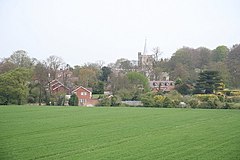
Ivinghoe is a village and civil parish within Aylesbury Vale district in Buckinghamshire, England, close to the border with Hertfordshire and Bedfordshire. It is four miles north of Tring and six miles south of Leighton Buzzard, close to the village of Pitstone.
Contents
1 Etymology
2 Location
3 Buildings
4 On Film
5 Schools
6 References
7 External links
Etymology
The village name is Anglo-Saxon in origin, and means 'Ifa's hill-spur'. In the Domesday Book of 1086 it was recorded as Evinghehou.
Location
Ivinghoe is situated within the Chiltern Hills, on the edge of the Chilterns' Area of Outstanding Natural Beauty.[2]
Ivinghoe is an important point on the Icknield Way, joining the Upper Icknield and Lower Icknield together. The Icknield Way is claimed to be the oldest road in Britain, dating back to the Celtic period, though this has been disputed.[3][4][5][6][7] Today the village is known as a starting point on The Ridgeway, a popular route for hikers and cyclists which uses part of the Icknield Way, running for 87 miles to Overton Hill in Wiltshire.
Ivinghoe Aston is a hamlet within the parish of Ivinghoe. Its name refers to a farm to the east of the main village. The hamlet has four farms, several houses and a public house, The Village Swan, which was bought by local residents in 1997.[8]
A small stream called Whistle Brook flows down through the hamlet, from the Chilterns above, to join the River Ouzel at nearby Slapton.
Another hamlet in Ivinghoe is Great Gap.
Buildings

St Mary's Church, Ivinghoe, from the East
The large church dates from 1220 but was set on fire in 1234 in an act of spite against the local Bishop. The church was rebuilt in 1241.
For a village Ivinghoe has an unusual feature: a town hall, rather than a village hall.[9] The village has some fine examples of Tudor architecture, particularly around the village green, with 28 buildings marked as listed or significant.[2]
Ivinghoe Beacon, near the village, is an ancient beacon, or signal point, which was used in times of crisis to send messages across the country and is now popular with walkers who just want to get exercise and see the view. It used to be used as a site for flying model aeroplanes but this has been forbidden due to accidents. The hill is the site of an early Iron age hill fort which, during excavations in the 1960s, was identified from bronzework finds to date back to the Bronze-Iron transition period between 800-700 BC. Like many other similar hill forts in the Chilterns it is thought to have been occupied for only a short period, possibly less than one generation.
Nearby is Pitstone Windmill, the oldest windmill in Britain that can be dated, which is owned by the National Trust.[10]
On Film
Scenes for feature films, such as Quatermass 2, Batman Begins,
Maleficent, The Dirty Dozen, as well as the BBC America production Killing Eve, have been shot at Ivinghoe Beacon.[11] Director Raymond Austin filmed the 1960s-1970's TV shows The Avengers, The New Avengers and The Saint in and around the village,[12] which once also served as a set for the children's TV series ChuckleVision.
Schools
Brookmead School is a mixed, foundation primary school in Ivinghoe. It takes children from the age of four through to the age of eleven. The school has 340 pupils.[13]
References
^ Neighbourhood Statistics 2011 Census, Accessed 3 February 2013
^ ab "Aylesbury Vale District Council Ivinghoe Conservation Area Review, 2015" (PDF). Retrieved 23 May 2018..mw-parser-output cite.citation{font-style:inherit}.mw-parser-output .citation q{quotes:"""""""'""'"}.mw-parser-output .citation .cs1-lock-free a{background:url("//upload.wikimedia.org/wikipedia/commons/thumb/6/65/Lock-green.svg/9px-Lock-green.svg.png")no-repeat;background-position:right .1em center}.mw-parser-output .citation .cs1-lock-limited a,.mw-parser-output .citation .cs1-lock-registration a{background:url("//upload.wikimedia.org/wikipedia/commons/thumb/d/d6/Lock-gray-alt-2.svg/9px-Lock-gray-alt-2.svg.png")no-repeat;background-position:right .1em center}.mw-parser-output .citation .cs1-lock-subscription a{background:url("//upload.wikimedia.org/wikipedia/commons/thumb/a/aa/Lock-red-alt-2.svg/9px-Lock-red-alt-2.svg.png")no-repeat;background-position:right .1em center}.mw-parser-output .cs1-subscription,.mw-parser-output .cs1-registration{color:#555}.mw-parser-output .cs1-subscription span,.mw-parser-output .cs1-registration span{border-bottom:1px dotted;cursor:help}.mw-parser-output .cs1-ws-icon a{background:url("//upload.wikimedia.org/wikipedia/commons/thumb/4/4c/Wikisource-logo.svg/12px-Wikisource-logo.svg.png")no-repeat;background-position:right .1em center}.mw-parser-output code.cs1-code{color:inherit;background:inherit;border:inherit;padding:inherit}.mw-parser-output .cs1-hidden-error{display:none;font-size:100%}.mw-parser-output .cs1-visible-error{font-size:100%}.mw-parser-output .cs1-maint{display:none;color:#33aa33;margin-left:0.3em}.mw-parser-output .cs1-subscription,.mw-parser-output .cs1-registration,.mw-parser-output .cs1-format{font-size:95%}.mw-parser-output .cs1-kern-left,.mw-parser-output .cs1-kern-wl-left{padding-left:0.2em}.mw-parser-output .cs1-kern-right,.mw-parser-output .cs1-kern-wl-right{padding-right:0.2em}
^ S. Harrison, "The Icknield Way: some queries", The Archaeological Journal, 160, 1–22, 2003.
^ K. Matthews, Circular Walk (Wilbury Hill, Ickleford, Cadwell, Wilbury Hill) Archived 13 May 2008 at the Wayback Machine.
^ R. Bradley, Solent Thames Research Assessment – the Neolithic and Early Bronze Age, 2008.
^ W.G. Clarke In Breckland Wilds, Heffer, Cambridge; 2nd edition, 1937; p.67.
^ Rhiannon, The Icknield Way: Miscellaneous, 2008.
^ "The Village Swan website". Retrieved 23 May 2018.
^ "Ivinghoe Town Hall website". Retrieved 23 May 2018.
^ "National Trust: Pitstone Windmill". Retrieved 23 May 2018.
^ "Leighton Buzzard Observer: Road closure today as BBC America drama filmed around Ivinghoe Beacon and residents warned about gun shots". Retrieved 23 May 2018.
^ "Avengerland TV location guide". Retrieved 23 May 2018.
^ "Brookmead School website". Retrieved 23 May 2018.
External links
| Wikimedia Commons has media related to Ivinghoe. |
- Village Website
- St Mary the Virgin Church Website
- Brookmead School
Aylesbury Vale District | ||
|---|---|---|
| ||
| Towns .mw-parser-output .nobold{font-weight:normal} (component areas and hamlets) |
|
 |
| Other civil parishes (component villages and hamlets) |
|
|
| Former districts and boroughs |
|
|
| Former constituencies |
|
|
| ||


Comments
Post a Comment