 Mixing
Tirukoilur
Tirukkovilur Koval Town | |
|---|---|
Town Panchayat | |
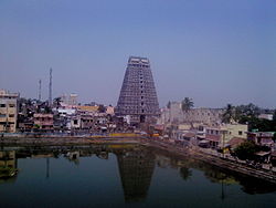 Tower of Ulagalantha Perumal Temple | |
 Tirukkovilur Location in Tamil Nadu, India | |
| Coordinates: 11°57′N 79°12′E / 11.95°N 79.2°E / 11.95; 79.2Coordinates: 11°57′N 79°12′E / 11.95°N 79.2°E / 11.95; 79.2 | |
| Country | |
| State | Tamil Nadu |
| District | villupuram district |
| Named for | Temples and Heritage |
| Government | |
| • Type | Sirappu Peruratchi |
| • Body | Chairman |
| Elevation | 73 m (240 ft) |
| Population (2011) | |
| • Total | 30,212 |
| Languages | |
| • Official | Tamil |
| Time zone | UTC+5:30 (IST) |
| Vehicle registration | TN-32 |
Tirukoilur or Tirukkoyilur also called Thirukkovalur or Kovalur.[1] is a town panchayt in villupuram district in the Indian state of Tamil Nadu. As the name says "koil" (means temple in Tamil language) it is famous for the temples. It is also spelled as Thirukkovilur or Thirukkoiloor situated on the banks of koil. The Veerataneshwara Shiva temple at East Thirukoilur and Ulagalantha Perumal temple, at west Tirukoyilur are located in this town.
Contents
1 East and West Tirukoilur (Keelaiyur and Melur)
2 Demographics
3 History
4 Significance
5 Transport
5.1 Road
5.2 Railway History
5.2.1 Train
5.2.2 Air
6 References
7 External links
East and West Tirukoilur (Keelaiyur and Melur)

Thirukovilur temple tower
A thousand years ago, Tirukoilur was one of the four largest cities in Tamil Nadu. The others being Kanchipuram, Madurai, and Thanjavur.[citation needed] Tirukkoyilur is located at 11°57′N 79°12′E / 11.95°N 79.2°E / 11.95; 79.2.[2] It has an average elevation of 73 metres (239 feet).
Demographics
As of 2014[update] India census,[3] Tirukkoyilur had a population of 30212. Males constitute 49% of the population and females 51%. Tirukkoyilur has an average literacy rate of 78%, higher than the national average of 59.5%: male literacy is 83%, and female literacy is 73%. In Tirukkoyilur, 10% of the population is under 6 years of age.
History
Tirukoilur is a place of historic importance due to Malayaman chieftains who were feudatories of the Cholas.
Significance

Veerateeswarar Temple
Tirukoilur, is a place where Vaishnavites (Worshippers of Lord Vishnu) and Shaivites (Worshippers of lord Shiva) co-existed with peace and harmony, knowing that Hari and Shiva are the different forms of same almighty.
Ulagalantha Perumal Temple or Trivikrama Temple at Tirukkoyilur is a Hindu temple dedicated to Lord Vishnu. Constructed in the Dravidian style of architecture, the temple is glorified in the Divya Prabandha, the early medieval Tamil canon of the Azhwar saints from the 6th–9th centuries AD. It is one of the 108 Divyadesam dedicated to Vishnu, who is worshipped as Ulagalantha Perumal and his consort Lakshmi as Poongothai.[4] The temple is believed to have been built by the Medieval Cholas, with later contributions from Vijayanagar kings and Madurai Nayaks. The temple covers an area of 5 acres (20,000 m2) and has a temple tower that is the third tallest in Tamil Nadu, measuring 192 ft (59 m) in height.
Veerateeswarar Temple (also called Thirukoilur Veerattam) in Tirukoilur is dedicated to the Lord Shiva. Constructed in the Dravidian style of architecture, the temple is believed to have been built during the Cholas period in the 10th century.[citation needed] Shiva is worshipped as Veerateeswarar and his consort Parvathi as Periyanayagi.
The presiding deity is revered in the 7th century Tamil Saiva canonical work, the Tevaram, written by Tamil saint poets known as the Nayanmars and classified as Paadal Petra Sthalam.
Tirukoilur is one of the Ashta Veeratanams, Ashta – eight Veeratanam – Place of Bravery. As per legends, Shiva is believed to have destroyed eight different demons namely Andakasuran, Gajasuran, Jalandasuran, Thirupuradhi, Kaman, Arjunan, Dakshan and Taaragasuran. There are eight temples built signifying each of his victories in the war,[5] and also as places where he is believed to have performed with fury.[6] The eight temples are: Tiruvadigai Veerattaaneswarar Temple at Thiruvadigai, Tirukkovilur Veerateshwarar Temple at Tirukoilur, Veerateswarar temple at Korukkai or Thirukkurukkai, Amirtagateswarar Temple at Thirukadaiyur, Vazhuvur Verateswarar Temple at Vazhuvoor, Keelaparasalur Veerateswarar Temple at Tirupariyalur, Kandeeswarar Temple at Thirukkandiyur and Tiruvirkudi Veerataneswarar Temple at Thiruvirkudi.[7] Shiva in all these temples are described to have used bow and arrow, trident and spear.
Tirukoilur Shiva's temple has a separate sannadhi[sacred room] for Lord Ganesha, which has historical and epic importance. This is the place where "Avvaiyar" (Tamil Poet – Tamil king's court had many Women Poets, Ministers and Warriors) got the blessings of Ganesha and wrote the famous verse "Vinayagar Agaval", which has wonderful Yoga Techniques and has lot of metaphysics in it.
Tirukoilur is also a highly regarded by Madhwas (followers of Dvaitha philosophy of Sri Madhwacharya). Manampoondi is a small village located near Tirukoilur. Manampoondi is 36 km away from Tiruvannamalai. It is at a distance of 2 km from Tirukoilur. On the banks of River Thenpennai we can find the Moola brindavana of Sri Raghuutthama Teertha (1595 A.D) and Sri Satyapramoda Teertha (1997), very eminent pontiffs of Uttaradi Mutt of Madhwa lineage.
The Tapovanam or Brindavanam of the great Hindu saint Gnanananda Giri is located on the banks of the river at Tirukkovilur.[8]
Adhirangam Ranganathaswamy temple, located 20 kilometres west of Tirukoilur is another famous Vaishnavite site.
Transport
Tirukoilur is well connected by Road & Rail.
Road
You have direct buses to major cities such as Chennai, Trichy, Salem Bengaluru, Kallakkurichi and Puducherry. From Viluppuram for every 10 to 15 minutes and from Tiruvannamalai every 10 to 15 minutes you will get buses to Tirukoilur. It is placed 33 km from Tiruvannamalai in Southeast direction,37 km from Villupuram in Southwest Directions.
Railway History
One of the Oldest railway station in Southern Railway. First Railway Track was proposed at 1857 from Walaja Road to Cuddalore via Tirukoilur.[9][better source needed]
A broad gauge railway line between Katpadi Junction and Villupuram passes through Tirukoilur and Tiruvannamalai. Passengers can board an Express / Passenger train to Katpadi / Vellore or Villupuram. The nearest major railway station is at Viluppuram Junction(40 km).
Train
The Chinnasalem town's railway station serves trains on the route to Mettur, Cuddalore, Nagore, Pondicherry, Salem, Coimbatore, Mangalore, Bangalore, Chennai and Mumbai.
Salem to Vriddhachalam passenger
Bangalore to Karaikkal Fast passenger
Salem to Chennai Egmore to dadar express
Puducherry to Mangalore weekly express
Yeshwantpur(Bangalore) to Puducherry garib rath
Erode to Chennai Egmore special daytime intercity express
Air
The nearest airport is at Puducherry Airport (70 km), Tiruchirapalli International Airport (180 km) and Chennai International Airport (198 km).
References
| Wikimedia Commons has media related to Tirukoyilur. |
^ "thirukoyilur (kovalur virattam) sthala puranam". www.shaivam.org. Retrieved 2015-10-23..mw-parser-output cite.citation{font-style:inherit}.mw-parser-output q{quotes:"""""""'""'"}.mw-parser-output code.cs1-code{color:inherit;background:inherit;border:inherit;padding:inherit}.mw-parser-output .cs1-lock-free a{background:url("//upload.wikimedia.org/wikipedia/commons/thumb/6/65/Lock-green.svg/9px-Lock-green.svg.png")no-repeat;background-position:right .1em center}.mw-parser-output .cs1-lock-limited a,.mw-parser-output .cs1-lock-registration a{background:url("//upload.wikimedia.org/wikipedia/commons/thumb/d/d6/Lock-gray-alt-2.svg/9px-Lock-gray-alt-2.svg.png")no-repeat;background-position:right .1em center}.mw-parser-output .cs1-lock-subscription a{background:url("//upload.wikimedia.org/wikipedia/commons/thumb/a/aa/Lock-red-alt-2.svg/9px-Lock-red-alt-2.svg.png")no-repeat;background-position:right .1em center}.mw-parser-output .cs1-subscription,.mw-parser-output .cs1-registration{color:#555}.mw-parser-output .cs1-subscription span,.mw-parser-output .cs1-registration span{border-bottom:1px dotted;cursor:help}.mw-parser-output .cs1-hidden-error{display:none;font-size:100%}.mw-parser-output .cs1-visible-error{font-size:100%}.mw-parser-output .cs1-subscription,.mw-parser-output .cs1-registration,.mw-parser-output .cs1-format{font-size:95%}.mw-parser-output .cs1-kern-left,.mw-parser-output .cs1-kern-wl-left{padding-left:0.2em}.mw-parser-output .cs1-kern-right,.mw-parser-output .cs1-kern-wl-right{padding-right:0.2em}
^ Falling Rain Genomics, Inc - Tirukkoyilur
^ "Census of India 2014: Data from the 2014 Census, including cities, villages and towns (Provisional)". Census Commission of India. Archived from the original on 2004-06-16. Retrieved 2008-11-01.
^ M. S., Ramesh. 108 Vaishnavite Divya Desams: Divya desams in Pandya Nadu. Tirumalai-Tirupati Devasthanam.
^ P., Karthigayan (2016). History of Medical and Spiritual Sciences of Siddhas of Tamil Nadu. Notion Press. p. 388. ISBN 9789352065523.
^ Madhavan 2014, p. 145
^ Cite error: The named referenceRwas invoked but never defined (see the help page).
^ http://www.gnanananda.org/swami_gnananda.html
^ Timeline of Southern Railway zone
https://archive.india.gov.in/govt/loksabhampbiodata.php?mpcode=6
External links
- http://www.tirukoilur.com


Comments
Post a Comment