 Mixing
South Fulton, Tennessee
South Fulton, Tennessee | |
|---|---|
City | |
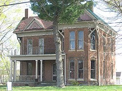 The W.W. Morris House, a historic site on State Line Road | |
 Location of South Fulton in Obion County, Tennessee. | |
| Coordinates: 36°29′48″N 88°52′45″W / 36.49667°N 88.87917°W / 36.49667; -88.87917Coordinates: 36°29′48″N 88°52′45″W / 36.49667°N 88.87917°W / 36.49667; -88.87917 | |
| Country | United States |
| State | Tennessee |
| County | Obion |
| Government | |
| • Mayor | David Lamb |
| Area | |
| • Total | 3.1 sq mi (8.0 km2) |
| • Land | 3.1 sq mi (8.0 km2) |
| • Water | 0.0 sq mi (0.0 km2) |
| Elevation | 351 ft (107 m) |
| Population (2010) | |
| • Total | 2,354 |
| • Estimate (2016)[1] | 2,256 |
| • Density | 814.4/sq mi (314.5/km2) |
| Time zone | UTC-6 (Central (CST)) |
| • Summer (DST) | UTC-5 (CDT) |
| ZIP code | 38257 |
| Area code(s) | 731 |
| FIPS code | 47-69900[2] |
GNIS feature ID | 1303727[3] |
South Fulton is a city in Obion County, Tennessee, United States. The population was 2,354 at the 2010 census. It is part of the Union City, TN–KY Micropolitan Statistical Area.
Contents
1 Geography
2 Demographics
3 Twin City
4 History
5 References
Geography
South Fulton is located at 36°29′48″N 88°52′45″W / 36.49667°N 88.87917°W / 36.49667; -88.87917 (36.496716, -88.879193).[4]
According to the United States Census Bureau, the city has a total area of 3.1 square miles (8.0 km2), all land.
Demographics
| Historical population | |||
|---|---|---|---|
| Census | Pop. | %± | |
| 1880 | 284 | — | |
| 1890 | 623 | 119.4% | |
| 1900 | 455 | −27.0% | |
| 1910 | 1,391 | 205.7% | |
| 1920 | 1,650 | 18.6% | |
| 1930 | 1,988 | 20.5% | |
| 1940 | 2,050 | 3.1% | |
| 1950 | 2,119 | 3.4% | |
| 1960 | 2,512 | 18.5% | |
| 1970 | 3,122 | 24.3% | |
| 1980 | 2,735 | −12.4% | |
| 1990 | 2,688 | −1.7% | |
| 2000 | 2,517 | −6.4% | |
| 2010 | 2,354 | −6.5% | |
| Est. 2016 | 2,256 | [1] | −4.2% |
| Sources:[5][6] | |||
As of the census[2] of 2000, there were 2,517 people, 1,081 households, and 729 families residing in the city. The population density was 814.4 people per square mile (314.5/km²). There were 1,199 housing units at an average density of 388.0 per square mile (149.8/km²). The racial makeup of the city was 78.98% White, 19.47% African American, 0.28% Native American, 0.12% Asian, 0.20% from other races, and 0.95% from two or more races. Hispanic or Latino of any race were 0.56% of the population.
There were 1,081 households out of which 27.3% had children under the age of 18 living with them, 48.2% were married couples living together, 15.6% had a female householder with no husband present, and 32.5% were non-families. 30.0% of all households were made up of individuals and 16.2% had someone living alone who was 65 years of age or older. The average household size was 2.30 and the average family size was 2.83.
In the city, the population was spread out with 22.9% under the age of 18, 7.8% from 18 to 24, 24.5% from 25 to 44, 25.5% from 45 to 64, and 19.3% who were 65 years of age or older. The median age was 42 years. For every 100 females, there were 85.9 males. For every 100 females age 18 and over, there were 83.8 males.
The median income for a household in the city was $27,462, and the median income for a family was $35,608. Males had a median income of $27,458 versus $20,212 for females. The per capita income for the city was $15,983. About 15.0% of families and 16.0% of the population were below the poverty line, including 22.2% of those under age 18 and 18.1% of those age 65 or over.
Twin City
South Fulton is considered a twin city with Fulton, Kentucky. Together, they used to host the International Banana Festival in celebration of the fact that the twin cities railroad maintained an icing station for a large percentage of bananas en route to northern destinations arriving from New Orleans. A two-ton banana pudding was marched through a parade and served at the end of the parade route.
Recently this Banana Festival was brought back in 2011. In 2012, they had the 50th anniversary of the Banana Festival. This festival occurs towards the end of September and includes the pudding, seller booths, and concessions.
History
South Fulton was first known as Jacksonvile, and was named aptly so since land in the area once belonged to Andrew Jackson. It is recorded that Andrew Jackson sold 1,000 acres (400 hectares) in northeast Weakley County in 1823. Jacksonville existed from about 1859 until 1895 when South Fulton was first chartered.
[7]
References
^ ab "Population and Housing Unit Estimates". Retrieved June 9, 2017..mw-parser-output cite.citation{font-style:inherit}.mw-parser-output .citation q{quotes:"""""""'""'"}.mw-parser-output .citation .cs1-lock-free a{background:url("//upload.wikimedia.org/wikipedia/commons/thumb/6/65/Lock-green.svg/9px-Lock-green.svg.png")no-repeat;background-position:right .1em center}.mw-parser-output .citation .cs1-lock-limited a,.mw-parser-output .citation .cs1-lock-registration a{background:url("//upload.wikimedia.org/wikipedia/commons/thumb/d/d6/Lock-gray-alt-2.svg/9px-Lock-gray-alt-2.svg.png")no-repeat;background-position:right .1em center}.mw-parser-output .citation .cs1-lock-subscription a{background:url("//upload.wikimedia.org/wikipedia/commons/thumb/a/aa/Lock-red-alt-2.svg/9px-Lock-red-alt-2.svg.png")no-repeat;background-position:right .1em center}.mw-parser-output .cs1-subscription,.mw-parser-output .cs1-registration{color:#555}.mw-parser-output .cs1-subscription span,.mw-parser-output .cs1-registration span{border-bottom:1px dotted;cursor:help}.mw-parser-output .cs1-ws-icon a{background:url("//upload.wikimedia.org/wikipedia/commons/thumb/4/4c/Wikisource-logo.svg/12px-Wikisource-logo.svg.png")no-repeat;background-position:right .1em center}.mw-parser-output code.cs1-code{color:inherit;background:inherit;border:inherit;padding:inherit}.mw-parser-output .cs1-hidden-error{display:none;font-size:100%}.mw-parser-output .cs1-visible-error{font-size:100%}.mw-parser-output .cs1-maint{display:none;color:#33aa33;margin-left:0.3em}.mw-parser-output .cs1-subscription,.mw-parser-output .cs1-registration,.mw-parser-output .cs1-format{font-size:95%}.mw-parser-output .cs1-kern-left,.mw-parser-output .cs1-kern-wl-left{padding-left:0.2em}.mw-parser-output .cs1-kern-right,.mw-parser-output .cs1-kern-wl-right{padding-right:0.2em}
^ ab "American FactFinder". United States Census Bureau. Retrieved 2008-01-31.
^ "US Board on Geographic Names". United States Geological Survey. 2007-10-25. Retrieved 2008-01-31.
^ "US Gazetteer files: 2010, 2000, and 1990". United States Census Bureau. 2011-02-12. Retrieved 2011-04-23.
^ "Census of Population and Housing: Decennial Censuses". United States Census Bureau. Retrieved 2012-03-04.
^ "Incorporated Places and Minor Civil Divisions Datasets: Subcounty Resident Population Estimates: April 1, 2010 to July 1, 2012". Population Estimates. U.S. Census Bureau. Archived from the original on 17 June 2013. Retrieved 11 December 2013.
^ "Archived copy". Archived from the original on 2011-11-24. Retrieved 2012-03-17.CS1 maint: Archived copy as title (link)
4. http://www.nbcnews.com/id/39516346/ns/us_news-life/t/no-pay-no-spray-firefighters-let-home-burn/
Municipalities and communities of Obion County, Tennessee, United States | ||
|---|---|---|
County seat: Union City | ||
| Cities |
| |
| Towns |
| |
| Unincorporated communities |
| |
| Footnotes | ‡This populated place also has portions in an adjacent county or counties | |


Comments
Post a Comment