 Mixing
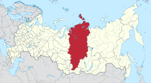
Krasnoyarsk Krai
Krasnoyarsk Krai | |||
|---|---|---|---|
Krai | |||
| Красноярский край | |||
| |||
| Anthem: [1] | |||
 | |||
| Coordinates: 59°53′N 91°40′E / 59.883°N 91.667°E / 59.883; 91.667Coordinates: 59°53′N 91°40′E / 59.883°N 91.667°E / 59.883; 91.667 | |||
| Country | Russia | ||
| Federal district | Siberian[9] | ||
| Economic region | East Siberian[10] | ||
| Established | December 7, 1934[6] | ||
| Administrative center | Krasnoyarsk | ||
| Government | |||
| • Body | Legislative Assembly[7] | ||
| • Governor[7] | Alexander Uss[8] | ||
| Area [11] | |||
| • Total | 2,339,700 km2 (903,400 sq mi) | ||
| Area rank | 2nd | ||
| Population (2010 Census)[4] | |||
| • Total | 2,828,187 | ||
| • Estimate (2018)[12] | 2,876,497 (+1.7%) | ||
| • Rank | 13th | ||
| • Density | 1.2/km2 (3.1/sq mi) | ||
| • Urban | 76.3% | ||
| • Rural | 23.7% | ||
| Time zone | UTC+7 (MSK+4 | ||
| ISO 3166 code | RU-KYA | ||
| License plates | 24, 124 | ||
| Official languages | Russian[14] | ||
OKTMO ID | 04000000 | ||
| Website | http://www.krskstate.ru | ||


Krasnoyarsk Krai (Russian: Красноя́рский край, tr. Krasnoyarsky kray, IPA: [krəsnɐˈjarskʲɪj ˈkraj]) is a federal subject of Russia (a krai), with its administrative center in the city of Krasnoyarsk—the third-largest city in Siberia (after Novosibirsk and Omsk). Comprising half of the Siberian Federal District, Krasnoyarsk Krai is the largest krai in the Russian Federation, the second largest federal subject (after the neighboring Sakha Republic) and the third largest subnational governing body by area in the world, after Sakha and the Australian state of Western Australia. The krai covers an area of 2,339,700 square kilometers (903,400 sq mi), which is nearly one quarter the size of the entire country of Canada (the next-largest country in the world after Russia), constituting roughly 13% of the Russian Federation's total area and containing a population of 2,828,187, or just under 2% of its population, per the 2010 Census.[4]
Contents
1 Geography
2 History
3 Politics
4 Economy
4.1 Natural resources
4.2 Industry
4.3 Power generation
4.4 Transportation
5 Administrative divisions
6 Demographics
6.1 Settlements
6.2 Demographics for 2007
6.3 Religion
7 Education
8 Nature and ecology
9 See also
10 References
10.1 Notes
10.2 Sources
11 External links
Geography
The krai lies in the middle of Siberia, and occupies nearly half of the Siberian Federal District, almost splitting it in half, stretching 3,000 km from the Sayan Mountains in the south along the Yenisei River to the Taymyr Peninsula in the north. It borders (counting clockwise from the sea) the Sakha Republic, Irkutsk, the Tuva Republic, the Republic of Khakassia, and Kemerovo, Tomsk, and Tyumen Oblasts, and the Kara Sea and Laptev Sea of the Arctic Ocean in the north.
The krai is located in the basin of the Arctic Ocean; a great number of rivers that flow through the krai drain into it eventually. The main rivers of the krai are the Yenisei, and its tributaries (from south to north): the Kan, the Angara, the Podkamennaya Tunguska, and the Nizhnyaya Tunguska.
There are also several thousand lakes in the krai. The largest lakes include Beloye, Belyo, Glubokoye, Itat, Khantayskoye, Labas, Lama, Pyasina, Taymyr, and Yessey. The rivers and lakes are rich with fish.
The climate is strongly continental with large temperature variations during the year. For the central and southern regions where most of the krai's population lives, long winters and short, hot summers are characteristic. The territory of Krasnoyarsk Krai experiences conditions of three climate belts: Arctic, Subarctic, and moderate. In the north there are less than 40 days with temperature above 10 °C (50 °F), while in the south there are 110–120 such days.
The average temperature in January is −36 °C (−33 °F) in the north and −18 °C (0 °F) in the south. The average temperature in July is +10 °C (50 °F) in the north and +20 °C (68 °F) in the south. The annual precipitation is 316 millimeters (12.4 in) (up to 1,200 millimeters (47 in) in foothills of the Sayan Mountains). Snow covers the central regions of the krai from early November until late March. The peaks of the Sayan Mountains higher than 2,400–2,600 m and those of the Putorana Plateau higher than 1,000–1,300 m are covered with permanent snow. Permafrost is widespread, especially in the north.
The coastline contains a number of prominent peninsulas - from west to east the main ones are the Minina Peninsula, Mikhaylova Peninsula, the Taymyr Peninsula (by far the largest, and itself containing the Zarya Peninsula, Oskara Peninsula and Chelyuskin Peninsula) and the Khara-Tumus Peninsula.
There are also a large number of islands off the krai's coast, the most prominent of which are (from west to east) Sibiryakov Island, Nosok Island, Dikson Island, Vern Island, Brekhovskiye Island (in the Yenisei Gulf), Krestovskiy Island, the Kamennye Islands, the Zveroboy Islands, the Labyrintovye Islands, the Plavnikovye Islands, Kolosovykh Island, the Mona Islands, Rykacheva Island, Gavrilova Island, Belukha and Prodolgovatyy Islands, the Nordenskiöld Archipelago, the Firnley Islands, the Heiberg Islands, Starokadomsky Island, Maly Taymyr Island, the Komsomolskaya Pravda Islands, the Faddey Islands, and the Saint Peter Islands. There are also a number of islands further out that fall under the administration of Krasnoyarsk Krai - the most prominent being Bolshoy Island, Sverdrup Island, the Izvestiy TSIK Islands, the Arkticheskiy Institut Islands, the Kirov Islands, Uyedineniya Island, Voronina Island, Severnaya Zemlya (the largest group), and Ushakov Island.
The highest point of the krai is Grandiozny Peak in the East Sayan Mountains at an elevation of 2,922 meters (9,587 ft).
History
According to archaeologists, the first people reached Siberia circa 40,000 BCE.[15] The grave-mounds and monuments of the Scythian culture in Krasnoyarsk Krai belong to the 7th century BCE and are ones of the oldest in Eurasia. A prince's grave, the Kurgan Arshan, discovered in 2001, is also located in the krai.
Russian settlement of the area (mostly by Cossacks) began in the 17th century. After the construction of the Trans-Siberian Railway the Russian colonization of the area strongly increased.
During both the Tsarist and the Bolsheviks' times the territory of Krasnoyarsk Krai was used as a place of exile of political enemies. The first leaders of the Soviet state, Vladimir Lenin and Joseph Stalin were exiled to what is now the krai in 1897–1900 and 1903, respectively. In Stalin's era numerous Gulag camps were located in the region.
In 1822, the Yeniseysk Governorate was created with Krasnoyarsk as its administrative center that covered territory very similar to that of the current krai.
On June 30, 1908, in the basin of the Podkamennaya Tunguska River, there occurred a powerful explosion most likely to have been caused by the air burst of a large meteoroid or comet fragment at an altitude of 5–10 kilometers (3–6 miles) above Earth's surface. The force of the explosion is estimated to be about 10–15 megatons. It flattened more than 2,000 square kilometers (500,000 acres) of pine forest and killed thousands of reindeer.
Krasnoyarsk Krai was created in 1934 after disaggregation of the West Siberian and East Siberian Krais and later included Taymyr and Evenk Autonomous Okrugs and Khakas Autonomous Oblast. In 1991, Khakassia separated from the krai and became a republic within the Russian Federation.
On January 1, 2007, following a referendum on the issue held on April 17, 2005, territories of Evenk and Taymyr Autonomous Okrugs were merged into the krai.
Politics

The seat of the oblast administration in the Revolution Square, 2005
During the Soviet period, the high authority in the oblast was shared between three persons: The first secretary of the Krasnoyarsk CPSU Committee (who in reality had the most authority), the chairman of the oblast Soviet (legislative power), and the Chairman of the oblast Executive Committee (executive power). Since 1991, CPSU lost all the power, and the head of the Oblast administration, and eventually the governor was appointed/elected alongside elected regional parliament.
The Charter of Krasnoyarsk Krai is the fundamental law of the region. The Legislative Assembly of Krasnoyarsk Krai is the province's regional standing legislative (representative) body. The Legislative Assembly exercises its authority by passing laws, resolutions, and other legal acts and by supervising the implementation and observance of the laws and other legal acts passed by it. The legislative assembly consists of 52 deputies. 22 of them are elected in 22 one-mandate electoral districts by plurality system, 2 in Taymyr, 2 in Evenkia, and 26 are elected by proportional system from the lists offered by political parties. The highest executive body is the Oblast Government, which includes territorial executive bodies such as district administrations, committees, and commissions that facilitate development and run the day to day matters of the province. The Oblast administration supports the activities of the Governor who is the highest official and acts as guarantor of the observance of the krai Charter in accordance with the Constitution of Russia.
In December 1991, president Boris Yeltsin appointed Arkady Veprev as the first governor of Krasnoyarsk Krai. In January 1993 Yeltsin appointed Valery Zubov as the second governor of Krasnoyarsk Krai. In Krasnoyarsk Territory governor elections were called. Zubov was elected in a universal election for a five-year term. The Legislative Assembly of Krasnoyarsk Krai was created as well.
In 1998, Zubov lost in the gubernatorial election to General Aleksandr Lebed, a politician well known in all Russia. In 2002 Lebed died in a helicopter accident.
In 2002, Alexander Khloponin, the governor of Taymyr Autonomous Okrug and an influential businessman was elected a governor of Krasnoyarsk Krai. In 2007, he was nominated by president Vladimir Putin for re-election, and Khloponin was elected by the legislative assembly for the second term.
In 2010, after Khloponin was promoted to the office of the president's envoy in the North Caucasian Federal District, Lev Kuznetsov, a businessman and politician from Khloponin's circle, became the new governor of the region.
Krasnoyarsk Krai is represented in the Federation Council of Russia, the upper house of the Russian parliament by two senators. In 2007, eight deputies were elected to the State Duma from Krasnoyarsk regional lists of different political parties.
Economy
Over 95% of the cities, a majority of the industrial enterprises, and all of the agriculture are concentrated in the south of the krai.
Natural resources
The krai is among the richest of Russia's regions in natural resources. Eighty percent of the country's nickel, 75% of its cobalt, 70% of its copper, 16% of its coal, and 10% of its gold are extracted here. Krasnoyarsk also produces 20% of the country's timber. More than 95% of Russian resources of platinum and platinoids are concentrated in the krai.
Industry
The krai's major industries are: non-ferrous metallurgy, energy, forestry, chemicals, and oil refining. The major financial industrial groups of Krasnoyarsk Krai are:
Basic Element (Krasnoyarsk Aluminium Plant, Achinsk Alumina Complex, Krasnoyarsk Pulp and Paper Plant)
Interros (Norilsk Nickel)
Evraz Group (iron mines, timber)
MDM Group (SUEK, Siberian Coal and Energy Company)
RusHydro (generation of electric power)
RZhD (railroads)
Power generation
The two most powerful hydroelectric plants in Russia are built on the Yenisei River, one is being built on the Angara, and several are being planned. It makes Krasnoyarsk Krai one of the most important producers of electric energy in Russia, and a desirable location for energy-intensive industries, such as aluminium plants.[citation needed]
Transportation
Trans-Siberian Railroad (650 km (400 mi) within Krasnoyarsk Krai), Norilsk Railroad (the most northern railroad in the world); North Siberian Railroad is planned.- Highways: M53 Baikal (Novosibirsk-Krasnoyarsk-Irkutsk), M54 Yenisei (Krasnoyarsk-Kyzyl-Mongolia) R409 Eniseiskiy trakt (Krasnoyarsk-Lesosibirsk-Yeniseysk).
Northern Sea Route and shipping on the Yenisei. The main ports are: Dudinka, Igarka, Turukhansk, Yeniseysk, Maklakovo, Strelka, Krasnoyarsk
- 26 airports, including an international airport (Yemelyanovo near Krasnoyarsk).
- Two pipes of Irkutsk-Anzhero-Sudzhensk petroleum pipeline.
- Major power transmission lines.
Administrative divisions
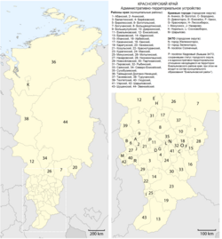
Krasnoyarsk Krai consists of forty-four districts and fourteen towns of district significance. Two of the districts (Evenkiysky and Taymyrsky; the former autonomous okrugs) have special status.
Demographics
Population (including former Taymyr and Evenk Autonomous Okrugs): 2,828,187 (2010 Census);[4]3,023,525 (2002 Census);[16]3,596,260 (1989 Census).[17]
Ethnic groups: The population of the krai mostly consists of Russians, and some other peoples of the former Soviet Union. The indigenous Siberian peoples make up no more than 1% of the population.
The 2010 Census reported the following ethnic composition:[4]
Russians: 91.3%
Ukrainians: 1.4%
Tatars: 1.3%
Germans: 0.8%
Azeri: 0.6%
Belarusians: 0.4%
Chuvash: 0.4%- others: 2.5%
- 100,621 people were registered from administrative databases, and could not declare an ethnicity. It is estimated that the proportion of ethnicities in this group is the same as that of the declared group.[18]
- Births (Jan-Aug 2009): 25,520 (13.3 per 1000) [19]
- Deaths (Jan-Aug 2009): 25,183 (13.1 per 1000)
As of August 2009, Krasnoyarsk Krai recorded a natural growth of population for the first time in 16 years.[20]
Total fertility rate:[21][22]
2003 - 1,35 | 2004 - 1,35 | 2005 - 1,31 | 2006 - 1,33 | 2007 - 1,44 | 2008 - 1,55 | 2009 - 1,61 | 2010 - 1,64 | 2011 - 1,64 | 2012 - 1,75 | 2013 - 1,78 | 2014 - 1,81 | 2015 - 1,84 | 2016 - 1,82(e)
- Vital statistics for 2012
- Births: 41 098 (14.5 per 1000)
- Deaths: 36 726 (12.9 per 1000) [23]
- Total fertility rate: 1.75
Settlements
Largest cities or towns in Krasnoyarsk Krai 2010 Russian Census | |||||||||
|---|---|---|---|---|---|---|---|---|---|
| Rank | Administrative Division | Pop. | |||||||
 Krasnoyarsk  Norilsk | 1 | Krasnoyarsk | City of krai significance of Krasnoyarsk | 1,035,528 |  Achinsk 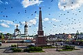 Kansk | ||||
| 2 | Norilsk | City of krai significance of Norilsk | 175,365 | ||||||
| 3 | Achinsk | Achinsky District | 109,155 | ||||||
| 4 | Kansk | Kansky District | 94,226 | ||||||
| 5 | Zheleznogorsk | Closed administrative-territorial formation of Zheleznogorsk | 84,795 | ||||||
| 6 | Minusinsk | Minusinsky District | 71,170 | ||||||
| 7 | Zelenogorsk | Closed administrative-territorial formation of Zelenogorsk | 66,056 | ||||||
| 8 | Lesosibirsk | Town of krai significance of Lesosibirsk | 61,139 | ||||||
| 9 | Nazarovo | Nazarovsky District | 52,817 | ||||||
| 10 | Sharypovo | Sharypovsky District | 38,561 | ||||||
Demographics for 2007
District | Pop[24] | Births | Deaths | NG | BR | DR | NGR |
|---|---|---|---|---|---|---|---|
Krasnoyarsk Krai | 2,890,350 | 34,206 | 38,470 | -4,264 | 11.83 | 13.31 | -0.15% |
Taimirsky Dolgano-Nenetsky District | 37,768 | 592 | 335 | 257 | 15.67 | 8.87 | 0.68% |
Evenkiysky District | 16,705 | 304 | 233 | 71 | 18.20 | 13.95 | 0.43% |
Abansky District | 24,997 | 346 | 419 | -73 | 13.84 | 16.76 | -0.29% |
Achinsky District | 15,918 | 226 | 253 | -27 | 14.20 | 15.89 | -0.17% |
Balakhtinsky District | 23,761 | 281 | 409 | -128 | 11.83 | 17.21 | -0.54% |
Beryozovsky District | 38,527 | 483 | 543 | -60 | 12.54 | 14.09 | -0.16% |
Birilyussky District | 11,431 | 159 | 228 | -69 | 13.91 | 19.95 | -0.60% |
Bogotolsky District | 11,371 | 151 | 233 | -82 | 13.28 | 20.49 | -0.72% |
Boguchansky District | 48,312 | 585 | 626 | -41 | 12.11 | 12.96 | -0.08% |
Bolshemurtinsky District | 19,292 | 207 | 398 | -191 | 10.73 | 20.63 | -0.99% |
Bolsheuluysky District | 8,540 | 112 | 157 | -45 | 13.11 | 18.38 | -0.53% |
Dzerzhinsky District | 15,025 | 180 | 298 | -118 | 11.98 | 19.83 | -0.79% |
Novosyolovsky District | 15,128 | 192 | 226 | -34 | 12.69 | 14.94 | -0.22% |
Partizansky District | 11,003 | 155 | 233 | -78 | 14.09 | 21.18 | -0.71% |
Pirovsky District | 8,251 | 97 | 125 | -28 | 11.76 | 15.15 | -0.34% |
Rybinsky District | 23,393 | 309 | 422 | -113 | 13.21 | 18.04 | -0.48% |
Sayansky District | 13,058 | 163 | 235 | -72 | 12.48 | 18.00 | -0.55% |
Severo-Yeniseysky District | 10,907 | 153 | 136 | 17 | 14.03 | 12.47 | 0.16% |
Sukhobuzimsky District | 23,050 | 287 | 362 | -75 | 12.45 | 15.70 | -0.33% |
Taseyevsky District | 13,962 | 161 | 234 | -73 | 11.53 | 16.76 | -0.52% |
Turukhansky District | 20,736 | 249 | 295 | -46 | 12.01 | 14.23 | -0.22% |
Tyukhtetsky District | 9,034 | 111 | 197 | -86 | 12.29 | 21.81 | -0.95% |
Uzhursky District | 33,952 | 541 | 586 | -45 | 15.93 | 17.26 | -0.13% |
Uyarsky District | 22,255 | 250 | 495 | -245 | 11.23 | 22.24 | -1.10% |
Idrinsky District | 14,037 | 157 | 252 | -95 | 11.18 | 17.95 | -0.68% |
Ilansky District | 26,436 | 352 | 453 | -101 | 13.32 | 17.14 | -0.38% |
Irbeysky District | 18,053 | 241 | 300 | -59 | 13.35 | 16.62 | -0.33% |
Kazachinsky District | 11,333 | 162 | 191 | -29 | 14.29 | 16.85 | -0.26% |
Sharypovsky District | 17,816 | 244 | 295 | -51 | 13.70 | 16.56 | -0.29% |
Shushensky District | 35,372 | 392 | 659 | -267 | 11.08 | 18.63 | -0.75% |
Krasnoyarsk | 905,000 | 10,585 | 10,936 | -351 | 11.70 | 12.08 | -0.04% |
Achinsk | 110,838 | 1,333 | 1,702 | -369 | 12.03 | 15.36 | -0.33% |
Bogotol | 21,997 | 273 | 407 | -134 | 12.41 | 18.50 | -0.61% |
Borodino | 18,759 | 197 | 247 | -50 | 10.50 | 13.17 | -0.27% |
Divnogorsk | 30,968 | 337 | 438 | -101 | 10.88 | 14.14 | -0.33% |
Yeniseysk | 19,086 | 265 | 278 | -13 | 13.88 | 14.57 | -0.07% |
Zaozyorny | 11,359 | 184 | 221 | -37 | 16.20 | 19.46 | -0.33% |
Kansk | 98,965 | 1,113 | 1,458 | -345 | 11.25 | 14.73 | -0.35% |
Lesosibirsk | 64,215 | 932 | 1,027 | -95 | 14.51 | 15.99 | -0.15% |
Minusinsk | 66,770 | 852 | 1,141 | -289 | 12.76 | 17.09 | -0.43% |
Nazarovo | 53,593 | 568 | 890 | -322 | 10.60 | 16.61 | -0.60% |
Norilsk | 206,359 | 2,402 | 1,150 | 1,252 | 11.64 | 5.57 | 0.61% |
Sosnovoborsk | 30,074 | 306 | 275 | 31 | 10.17 | 9.14 | 0.10% |
Sharypovo | 38,495 | 599 | 583 | 16 | 15.56 | 15.14 | 0.04% |
Yemelyanovsky District | 45,908 | 493 | 633 | -140 | 10.74 | 13.79 | -0.30% |
Kansky District | 26,696 | 361 | 425 | -64 | 13.52 | 15.92 | -0.24% |
Karatuzsky District | 16,992 | 215 | 307 | -92 | 12.65 | 18.07 | -0.54% |
Kezhemsky District | 24,406 | 277 | 300 | -23 | 11.35 | 12.29 | -0.09% |
Kozulsky District | 18,292 | 225 | 344 | -119 | 12.30 | 18.81 | -0.65% |
Krasnoturansky District | 16,098 | 201 | 247 | -46 | 12.49 | 15.34 | -0.29% |
Kuraginsky District | 51,402 | 669 | 851 | -182 | 13.02 | 16.56 | -0.35% |
Mansky District | 17,684 | 226 | 365 | -139 | 12.78 | 20.64 | -0.79% |
Minusinsky District | 26,457 | 339 | 409 | -70 | 12.81 | 15.46 | -0.26% |
Motyginsky District | 18,152 | 238 | 257 | -19 | 13.11 | 14.16 | -0.10% |
Nazarovsky District | 23,609 | 390 | 356 | 34 | 16.52 | 15.08 | 0.14% |
Yeniseysky District | 27,044 | 353 | 418 | -65 | 13.05 | 15.46 | -0.24% |
Yermakovsky District | 20,621 | 310 | 360 | -50 | 15.03 | 17.46 | -0.24% |
Nizhneingashsky District | 35,886 | 448 | 597 | -149 | 12.48 | 16.64 | -0.42% |
| Other | 245,202 | 1,673 | 2,020 | -347 | 6.82 | 8.24 | -0.14% |
Religion
As a survey conducted in 2012,[25] 29.6% of the population of Krasnoyarsk Krai adheres to the Russian Orthodox Church, 5% declares to be a nondenominational Christian (excluding Protestant churches), 2% is an Orthodox Christian believer without belonging to any church or is a member of other (non-Russian) Orthodox churches, 1.5% is Muslim, 1% follows the Slavic native faith (Rodnovery), and 10.9% did not give an answer to the survey. In addition, 35% of the population declares to be "spiritual but not religious" and 15% to be atheist.[25]
Education
Krasnoyarsk is the site of the Siberian Federal University, one of the four largest educational institutions of Russia.
Nature and ecology
Many important industrial cities of Krasnoyarsk Krai, such as Krasnoyarsk, Norilsk, Achinsk, Kansk, Zheleznogorsk, and Minusinsk, suffer from environmental pollution.[citation needed]
See also
 Krasnoyarsk Krai portal
- List of Chairmen of the Legislative Assembly of Krasnoyarsk Krai
References
Notes
^ According to Article 24 of the Charter of Krasnoyarsk Krai, the symbols of the krai include a flag and a coat of arms, but not an anthem.
^ Charter of Krasnoyarsk Krai, Article 26
^ Charter of Krasnoyarsk Krai, Article 28
^ abcd Russian Federal State Statistics Service (2011). "Всероссийская перепись населения 2010 года. Том 1" [2010 All-Russian Population Census, vol. 1]. Всероссийская перепись населения 2010 года [2010 All-Russia Population Census] (in Russian). Federal State Statistics Service..mw-parser-output cite.citation{font-style:inherit}.mw-parser-output .citation q{quotes:"""""""'""'"}.mw-parser-output .citation .cs1-lock-free a{background:url("//upload.wikimedia.org/wikipedia/commons/thumb/6/65/Lock-green.svg/9px-Lock-green.svg.png")no-repeat;background-position:right .1em center}.mw-parser-output .citation .cs1-lock-limited a,.mw-parser-output .citation .cs1-lock-registration a{background:url("//upload.wikimedia.org/wikipedia/commons/thumb/d/d6/Lock-gray-alt-2.svg/9px-Lock-gray-alt-2.svg.png")no-repeat;background-position:right .1em center}.mw-parser-output .citation .cs1-lock-subscription a{background:url("//upload.wikimedia.org/wikipedia/commons/thumb/a/aa/Lock-red-alt-2.svg/9px-Lock-red-alt-2.svg.png")no-repeat;background-position:right .1em center}.mw-parser-output .cs1-subscription,.mw-parser-output .cs1-registration{color:#555}.mw-parser-output .cs1-subscription span,.mw-parser-output .cs1-registration span{border-bottom:1px dotted;cursor:help}.mw-parser-output .cs1-ws-icon a{background:url("//upload.wikimedia.org/wikipedia/commons/thumb/4/4c/Wikisource-logo.svg/12px-Wikisource-logo.svg.png")no-repeat;background-position:right .1em center}.mw-parser-output code.cs1-code{color:inherit;background:inherit;border:inherit;padding:inherit}.mw-parser-output .cs1-hidden-error{display:none;font-size:100%}.mw-parser-output .cs1-visible-error{font-size:100%}.mw-parser-output .cs1-maint{display:none;color:#33aa33;margin-left:0.3em}.mw-parser-output .cs1-subscription,.mw-parser-output .cs1-registration,.mw-parser-output .cs1-format{font-size:95%}.mw-parser-output .cs1-kern-left,.mw-parser-output .cs1-kern-wl-left{padding-left:0.2em}.mw-parser-output .cs1-kern-right,.mw-parser-output .cs1-kern-wl-right{padding-right:0.2em}
^ Krasnoyarsk Krai Territorial Branch of the Federal State Statistics Service. Социально-экономическое положение Красноярского края в январе–марте 2015 года (in Russian)
^ Resolution of December 7, 1934
^ ab Charter of Krasnoyarsk Krai, Article 46
^ Official website of Krasnoyarsk krai. Viktor Alexandrovich Tolokonsky, Governor of Krasnoyarsk Krai (in Russian)
^ Президент Российской Федерации. Указ №849 от 13 мая 2000 г. «О полномочном представителе Президента Российской Федерации в федеральном округе». Вступил в силу 13 мая 2000 г. Опубликован: "Собрание законодательства РФ", №20, ст. 2112, 15 мая 2000 г. (President of the Russian Federation. Decree #849 of May 13, 2000 On the Plenipotentiary Representative of the President of the Russian Federation in a Federal District. Effective as of May 13, 2000.).
^ Госстандарт Российской Федерации. №ОК 024-95 27 декабря 1995 г. «Общероссийский классификатор экономических регионов. 2. Экономические районы», в ред. Изменения №5/2001 ОКЭР. (Gosstandart of the Russian Federation. #OK 024-95 December 27, 1995 Russian Classification of Economic Regions. 2. Economic Regions, as amended by the Amendment #5/2001 OKER. ).
^ Федеральная служба государственной статистики (Federal State Statistics Service) (2004-05-21). "Территория, число районов, населённых пунктов и сельских администраций по субъектам Российской Федерации (Territory, Number of Districts, Inhabited Localities, and Rural Administration by Federal Subjects of the Russian Federation)". Всероссийская перепись населения 2002 года (All-Russia Population Census of 2002) (in Russian). Federal State Statistics Service. Retrieved 2011-11-01.
^ "26. Численность постоянного населения Российской Федерации по муниципальным образованиям на 1 января 2018 года". Federal State Statistics Service. Retrieved 23 January 2019.
^ "Об исчислении времени". Официальный интернет-портал правовой информации (in Russian). 3 June 2011. Retrieved 19 January 2019.
^ Official throughout the Russian Federation according to Article 68.1 of the Constitution of Russia.
^ "Arctic Social Sciences - Arctic Studies Center". Mnh.si.edu. Retrieved 2012-09-27.
^ Russian Federal State Statistics Service (21 May 2004). "Численность населения России, субъектов Российской Федерации в составе федеральных округов, районов, городских поселений, сельских населённых пунктов – районных центров и сельских населённых пунктов с населением 3 тысячи и более человек" [Population of Russia, Its Federal Districts, Federal Subjects, Districts, Urban Localities, Rural Localities—Administrative Centers, and Rural Localities with Population of Over 3,000] (XLS). Всероссийская перепись населения 2002 года [All-Russia Population Census of 2002] (in Russian).
^ "Всесоюзная перепись населения 1989 г. Численность наличного населения союзных и автономных республик, автономных областей и округов, краёв, областей, районов, городских поселений и сёл-райцентров" [All Union Population Census of 1989: Present Population of Union and Autonomous Republics, Autonomous Oblasts and Okrugs, Krais, Oblasts, Districts, Urban Settlements, and Villages Serving as District Administrative Centers]. Всесоюзная перепись населения 1989 года [All-Union Population Census of 1989] (in Russian). Институт демографии Национального исследовательского университета: Высшая школа экономики [Institute of Demography at the National Research University: Higher School of Economics]. 1989 – via Demoscope Weekly.
^ "Перепись-2010: русских становится больше". Perepis-2010.ru. 2011-12-19. Retrieved 2012-09-27.
^ http://www.statis.krs.ru/digital/region5/2007/Показатели%20естественного%20движения%20населения.pdf
^ "Новости Красноярска и Красноярского края — ИА "Пресс-Лайн"". Press-line.ru. Retrieved 2012-09-27.
^ Население ::Красноярскстат. Krasstat.gks.ru. Retrieved on 2013-08-20.
^ http://www.gks.ru/wps/wcm/connect/rosstat_main/rosstat/ru/statistics/publications/catalog/doc_1137674209312
^ Естественное движение населения в разрезе субъектов Российской Федерации. Gks.ru. Retrieved on 2013-08-20.
^ "Территориальный орган Федеральной службы государственной статистики по Красноярскому краю - Население". Statis.krs.ru. Retrieved 2012-09-27.
^ abc "Arena: Atlas of Religions and Nationalities in Russia". Sreda, 2012.
^ 2012 Arena Atlas Religion Maps. "Ogonek", № 34 (5243), 27/08/2012. Retrieved 21/04/2017. Archived.
Sources
Законодательное Собрание Красноярского края. №5-1777 5 июня 2008 г. «Устав Красноярского края», в ред. Закона №4-1178 от 4 апреля 2013 г. «Об изменении статей 62 и 90 Устава Красноярского края в связи с принятием Федерального закона от 3 декабря 2012 года №229-ФЗ "О порядке формирования Совета Федерации Федерального Собрания Российской Федерации"». Вступил в силу 24 июня 2008 г. (за исключением отдельных положений). Опубликован: "Краевой вестник", №1 (спецвыпуск), 11 июня 2008 г. (Legislative Assembly of Krasnoyarsk Krai. #5-1777 June 5, 2008 Charter of Krasnoyarsk Krai, as amended by the Law #4-1178 of April 4, 2013 On Amending Articles 62 and 90 of the Charter of Krasnoyarsk Krai Due to the Adoption of the Federal Law #229-FZ of December 3, 2012 "On the Procedures of the Formation of the Federation Council of the Federal Assembly of the Russian Federation". Effective as of June 24, 2008 (with the exception of certain clauses).).
Всероссийский Центральный Исполнительный Комитет. Постановление от 7 декабря 1934 г. «О разукрупнении Западносибирского и Восточносибирского краёв и образовании новых областей в Сибири». (All-Russian Central Executive Committee. Resolution of December 7, 1934 On the Subdivision of West Siberian and East Siberian Krais and on the Establishment of New Oblasts in Siberia. ).
External links
| Wikimedia Commons has media related to Krasnoyarsk Krai. |
Official website of Krasnoyarsk Krai (in Russian)
Putorana Plateau at Natural Heritage Protection Fund
- Пантелеев В. НА ПЕРЕЛОМЕ: Аркадий Вепрев у руля. Победа Валерия Зубова на губернаторских выборах//Красноярский рабочий.- 2011. - №145.- 19 августа.
 Chisholm, Hugh, ed. (1911). "Yeniseisk". Encyclopædia Britannica. 28 (11th ed.). Cambridge University Press. pp. 914–915.
| |||||||||||||||||
| |||||||||||||||||
Authority control |
|
|---|


Comments
Post a Comment