 Mixing
Unorganized Kenora District
Unorganized Kenora District | |
|---|---|
Unorganized area | |
| Kenora, Unorganized | |
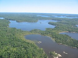 Scenery near Minaki | |
 | |
| Coordinates: 53°00′N 89°00′W / 53.000°N 89.000°W / 53.000; -89.000Coordinates: 53°00′N 89°00′W / 53.000°N 89.000°W / 53.000; -89.000 | |
| Country | |
| Province | |
| District | Kenora |
| Government | |
| • Federal riding | Kenora, Timmins—James Bay |
| • Prov. riding | Kenora—Rainy River, Timmins—James Bay |
| Area [1] | |
| • Land | 400,771.81 km2 (154,738.86 sq mi) |
| Population (2011)[1] | |
| • Total | 7,031 |
| • Density | 0.02/km2 (0.05/sq mi) |
| Time zones | UTC-5 (EST) |
UTC-6 (CST) |
|
| • Summer (DST) | UTC-4 (EDT) |
UTC-5 (CDT) |
|
| Postal Code FSA | P |
| Area code(s) | 705, 807 |
Unorganized Kenora District is an unorganized area in northwestern Ontario, Canada, in Kenora District. Comprising 98.39 percent of the district's land area, yet only 10.93 percent of its population, it is essentially the remainder of the district's territory after all incorporated cities, municipalities, townships, Indian reserves, and Indian settlements have been excluded. It is by far the largest municipal-equivalent level census division in Ontario, covering over 35 percent of the entire provincial land area, yet only about 0.05 percent of the population of Ontario.
Contents
1 Local services boards
2 Demographics
3 See also
4 External links
5 References
Local services boards
- Greater Oxdrift
- Melgund
- Minaki
- Redditt
- Round Lake
- Wabigoon
Demographics
| Canada census – Kenora, Unorganized community profile | |||
|---|---|---|---|
2011 |
2006 |
||
| Population: |
7031 (-0.1% from 2006) |
7041 (-7.7% from 2001) |
|
| Land area: |
400,771.81 km2 (154,738.86 sq mi) |
400,652.34 km2 (154,692.73 sq mi) |
|
| Population density: |
0.0/km2 (0/sq mi) |
0.0/km2 (0/sq mi) |
|
| Median age: |
44.3 (M: 44.9, F: 43.8) |
||
| Total private dwellings: |
7394 |
7603 |
|
| Median household income: |
$43,499 |
||
| References: 2011[2] 2006[3] earlier[4] | |||
Population trend:[5]
- Population in 2011: 7,031
- Population in 2006: 7,041
- Population in 2001: 7,631
- Population in 1996: 10,269 (or 7,981 when adjusted to 2001 boundaries)
- Population in 1991: 9,723
See also
- List of townships in Ontario
- Sand Point Lake, Ontario
External links
- Presentation of Unorganized Kenora District - Statistics Canada
References
^ ab "Kenora, Unorganized census profile". 2011 Census of Population. Statistics Canada. Retrieved 2012-02-10..mw-parser-output cite.citation{font-style:inherit}.mw-parser-output .citation q{quotes:"""""""'""'"}.mw-parser-output .citation .cs1-lock-free a{background:url("//upload.wikimedia.org/wikipedia/commons/thumb/6/65/Lock-green.svg/9px-Lock-green.svg.png")no-repeat;background-position:right .1em center}.mw-parser-output .citation .cs1-lock-limited a,.mw-parser-output .citation .cs1-lock-registration a{background:url("//upload.wikimedia.org/wikipedia/commons/thumb/d/d6/Lock-gray-alt-2.svg/9px-Lock-gray-alt-2.svg.png")no-repeat;background-position:right .1em center}.mw-parser-output .citation .cs1-lock-subscription a{background:url("//upload.wikimedia.org/wikipedia/commons/thumb/a/aa/Lock-red-alt-2.svg/9px-Lock-red-alt-2.svg.png")no-repeat;background-position:right .1em center}.mw-parser-output .cs1-subscription,.mw-parser-output .cs1-registration{color:#555}.mw-parser-output .cs1-subscription span,.mw-parser-output .cs1-registration span{border-bottom:1px dotted;cursor:help}.mw-parser-output .cs1-ws-icon a{background:url("//upload.wikimedia.org/wikipedia/commons/thumb/4/4c/Wikisource-logo.svg/12px-Wikisource-logo.svg.png")no-repeat;background-position:right .1em center}.mw-parser-output code.cs1-code{color:inherit;background:inherit;border:inherit;padding:inherit}.mw-parser-output .cs1-hidden-error{display:none;font-size:100%}.mw-parser-output .cs1-visible-error{font-size:100%}.mw-parser-output .cs1-maint{display:none;color:#33aa33;margin-left:0.3em}.mw-parser-output .cs1-subscription,.mw-parser-output .cs1-registration,.mw-parser-output .cs1-format{font-size:95%}.mw-parser-output .cs1-kern-left,.mw-parser-output .cs1-kern-wl-left{padding-left:0.2em}.mw-parser-output .cs1-kern-right,.mw-parser-output .cs1-kern-wl-right{padding-right:0.2em}
^ "2011 Community Profiles". 2011 Canadian Census. Statistics Canada. July 5, 2013. Retrieved 2012-02-10.
^ "2006 Community Profiles". 2006 Canadian Census. Statistics Canada. March 30, 2011. Retrieved 2011-06-28.
^ "2001 Community Profiles". 2001 Canadian Census. Statistics Canada. February 17, 2012.
^ Statistics Canada: 1996, 2001, 2006 census
Places adjacent to Unorganized Kenora District | ||||||||||
|---|---|---|---|---|---|---|---|---|---|---|
| ||||||||||
Kenora District, Ontario | ||
|---|---|---|
| Cities |
|
 |
| Towns |
|
|
| Townships |
|
|
| First Nations |
|
|
| Indian reserves |
|
|
| Indian settlements |
|
|
| Unorganized areas |
|
|
| Local services boards |
|
|
| Unincorporated communities |
|
|
| ||
This Northern Ontario geographical article is a stub. You can help Wikipedia by expanding it. |


Comments
Post a Comment