 Mixing
Cofre de Perote
| Cofre de Perote | |
|---|---|
 Cofre de Perote | |
| Highest point | |
| Elevation | 4,282 m (14,049 ft) [1] |
| Prominence | 1,340 m (4,400 ft) |
| Listing |
|
| Coordinates | 19°29.52′N 97°9′W / 19.49200°N 97.150°W / 19.49200; -97.150Coordinates: 19°29.52′N 97°9′W / 19.49200°N 97.150°W / 19.49200; -97.150 |
| Geography | |
| Location | Perote Municipality, Veracruz, Mexico |
| Geology | |
| Mountain type | Shield volcano |
| Volcanic belt | Trans-Mexican Volcanic Belt |
| Last eruption | 1150 CE ± 100 years |
| Climbing | |
| Easiest route | rock climb |
Contents
1 Geography
2 Climate
3 See also
4 References
5 External links
Geography
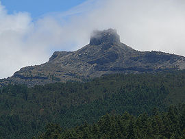
Cofre de Perote, also known by its Nahuatl names Naupa-Tecutépetl (from Nāuhpa-Tēuctēpetl) and Nauhcampatépetl, both meaning something like "Place of Four Mountain" or "Mountain of the Lord of Four Places", is an inactive volcano located in the Mexican state of Veracruz, at the point where the Trans-Mexican Volcanic Belt, home to all of Mexico's highest peaks, joins the Sierra Madre Oriental. With an elevation of 4,282 metres (14,049 ft) above sea level, Cofre de Perote is Mexico's eighth highest mountain summit.
Cofre de Perote is a shield volcano, shaped very differently from the stratovolcanic Pico de Orizaba, which lies about 50 km (31 mi) to the southeast. A cofre is a coffer, and the name alludes to a volcanic outcropping on the shield which constitutes the peak of the mountain. To the north is the town of Perote, Veracruz, after which the mountain is named.
The area surrounding the volcano was protected by the Mexican government as a national park, known as Cofre de Perote National Park (Spanish: Parque Nacional Cofre de Perote), in 1937.

Cofre de Perote from the northwest

Aerial view of Cofre de Perote from the northwest, with Pico de Orizaba and Sierra Negra visible to the south
Climate
Cofre de Perote features a humid alpine climate (Köppen climate classification ET), without a dry season but having a rainier season in summer and autumn.
| Climate data for Cofre de Perote | |||||||||||||
|---|---|---|---|---|---|---|---|---|---|---|---|---|---|
| Month |
Jan |
Feb |
Mar |
Apr |
May |
Jun |
Jul |
Aug |
Sep |
Oct |
Nov |
Dec |
Year |
| Average high °C (°F) |
2.2 (36.0) |
4.8 (40.6) |
6.1 (43.0) |
7.3 (45.1) |
8.4 (47.1) |
6.7 (44.1) |
6.0 (42.8) |
7.1 (44.8) |
6.8 (44.2) |
6.0 (42.8) |
5.4 (41.7) |
4.5 (40.1) |
5.9 (42.7) |
| Daily mean °C (°F) |
−0.1 (31.8) |
2.7 (36.9) |
3.4 (38.1) |
5.1 (41.2) |
6.6 (43.9) |
5.2 (41.4) |
4.1 (39.4) |
4.8 (40.6) |
5.0 (41.0) |
4.2 (39.6) |
3.3 (37.9) |
2.1 (35.8) |
3.9 (39.0) |
| Average low °C (°F) |
−2.3 (27.9) |
0.7 (33.3) |
0.8 (33.4) |
3.0 (37.4) |
4.9 (40.8) |
3.6 (38.5) |
2.3 (36.1) |
2.6 (36.7) |
3.2 (37.8) |
2.4 (36.3) |
1.2 (34.2) |
−0.3 (31.5) |
1.8 (35.3) |
| Average precipitation mm (inches) |
41.2 (1.62) |
44.2 (1.74) |
44.7 (1.76) |
61.7 (2.43) |
100.7 (3.96) |
360.0 (14.17) |
422.2 (16.62) |
397.6 (15.65) |
426.9 (16.81) |
200.0 (7.87) |
69.0 (2.72) |
54.1 (2.13) |
2,222.3 (87.48) |
| Average precipitation days (≥ 0.1 mm) |
22.1 |
22.4 |
29.3 |
27.1 |
27.9 |
28.9 |
28.6 |
30.4 |
29.3 |
29.1 |
20.1 |
21.2 |
316.4 |
| Average snowy days |
19.2 |
4.3 |
3.8 |
2.5 |
0.5 |
0.4 |
0.4 |
0.3 |
0.6 |
0.9 |
1.6 |
2.6 |
37.1 |
| [citation needed] | |||||||||||||
See also
List of mountain peaks of North America
List of mountain peaks of Mexico
- List of volcanoes in Mexico
References
^ INEGI. Anuario Estadístico de los Estados Unidos Mexicanos 2010. Consultado el 16 de Septiembre de 2014. "Archived copy" (PDF). Archived from the original (PDF) on 2015-04-02. Retrieved 2014-09-16.CS1 maint: Archived copy as title (link) .mw-parser-output cite.citation{font-style:inherit}.mw-parser-output q{quotes:"""""""'""'"}.mw-parser-output code.cs1-code{color:inherit;background:inherit;border:inherit;padding:inherit}.mw-parser-output .cs1-lock-free a{background:url("//upload.wikimedia.org/wikipedia/commons/thumb/6/65/Lock-green.svg/9px-Lock-green.svg.png")no-repeat;background-position:right .1em center}.mw-parser-output .cs1-lock-limited a,.mw-parser-output .cs1-lock-registration a{background:url("//upload.wikimedia.org/wikipedia/commons/thumb/d/d6/Lock-gray-alt-2.svg/9px-Lock-gray-alt-2.svg.png")no-repeat;background-position:right .1em center}.mw-parser-output .cs1-lock-subscription a{background:url("//upload.wikimedia.org/wikipedia/commons/thumb/a/aa/Lock-red-alt-2.svg/9px-Lock-red-alt-2.svg.png")no-repeat;background-position:right .1em center}.mw-parser-output .cs1-subscription,.mw-parser-output .cs1-registration{color:#555}.mw-parser-output .cs1-subscription span,.mw-parser-output .cs1-registration span{border-bottom:1px dotted;cursor:help}.mw-parser-output .cs1-hidden-error{display:none;font-size:100%}.mw-parser-output .cs1-visible-error{font-size:100%}.mw-parser-output .cs1-subscription,.mw-parser-output .cs1-registration,.mw-parser-output .cs1-format{font-size:95%}.mw-parser-output .cs1-kern-left,.mw-parser-output .cs1-kern-wl-left{padding-left:0.2em}.mw-parser-output .cs1-kern-right,.mw-parser-output .cs1-kern-wl-right{padding-right:0.2em}
"Cofre de Perote". Global Volcanism Program. Smithsonian Institution.
External links
Cofre de Peroteat Wikipedia's sister projects
 Definitions from Wiktionary
 Media from Wikimedia Commons
 News from Wikinews
 Quotations from Wikiquote
 Texts from Wikisource
 Textbooks from Wikibooks
 Resources from Wikiversity
- Programa de manejo del Parque nacional Cofre de Perote, Universidad Veracruzana
Xalapa (capital) | |||||||||||||||||||||||
| |||||||||||||||||||||||


Comments
Post a Comment