 Mixing
Upper Silesia plebiscite
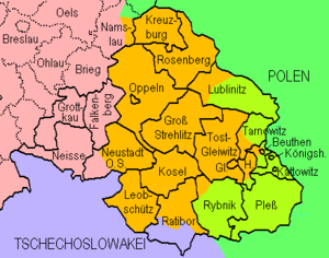
Map of the plebiscite areas
Pink = Germany
Green = Poland
Lilac = Czechoslovakia (including, without plebiscite, Hlučín)
Pale green = to Poland following plebiscite
Orange = remaining in Germany following plebiscite
The Upper Silesia plebiscite was a plebiscite mandated by the Versailles Treaty and carried out on 20 March 1921 to determine a section of the border between Weimar Germany and Poland. The region was ethnically mixed with both Germans and Poles; according to prewar statistics, ethnic Poles formed 60 percent of the population.[1] Under the previous rule by the German Empire, Poles claimed they had faced discrimination, making them effectively second class citizens.[2][3][4] The period of the plebiscite campaign and inter-Allied occupation was marked by violence. There were three Polish uprisings, and German volunteer paramilitary units came to the region as well.
The area was policed by French, British, and Italian troops, and overseen by an Inter-Allied Commission. The Allies planned a partition of the region, but a Polish insurgency took control of over half the area. The Germans responded with volunteer paramilitary units from all over Germany[citation needed], which fought the Polish units. In the end, after renewed Allied military intervention, the final position of the opposing forces became, roughly, the new border. The decision was handed over to the League of Nations, which confirmed this border, and Poland received roughly one third of the plebiscite zone by area, including the greater part of the industrial region.
After the referendum, on 20 October 1921, an ambassadors conference in Paris decided to divide the region. Consequently, the German-Polish Accord on East Silesia (Geneva Convention), a minority treaty was concluded on 15 May 1922 which dealt with the constitutional and legal future of Upper Silesia which has partly became Polish territory.
Contents
1 Ethnolinguistic structure before the plebiscite
2 The plebiscite
2.1 Results
3 Settlements which voted to secede for Poland
4 Hlučín region
5 See also
6 References
7 External links
Ethnolinguistic structure before the plebiscite
The earliest exact census figures on ethnolinguistic or national structure (Nationalverschiedenheit) of the Prussian part of Upper Silesia, come from 1819. The last pre-World War I general census figures available, are from 1910 (if not including the 1911 census of school children - Sprachzählung unter den Schulkindern - which revealed a higher percent of Polish-speakers among school children than the 1910 census among the general populace). Figures (Table 1.) show that large demographic changes took place between 1819 and 1910, with the region's total population quadrupling, the percent of German-speakers increasing significantly, and that of Polish-speakers declining considerably. Also the total land area in which Polish was spoken, as well as the land area in which it was spoken by the majority, declined between 1790 and 1890.[5]
| Table 1. Numbers of Polish-speaking and German-speaking inhabitants (Regierungsbezirk Oppeln) | |||||||||||||||
|---|---|---|---|---|---|---|---|---|---|---|---|---|---|---|---|
Year | 1819 [6] | 1828 [7] | 1831 [7] | 1837 [7] | 1840 [7] | 1843 [7] | 1846 [7] | 1852 [7] | 1858 [7] | 1861 [7] | 1867 [7] | 1890 [8] | 1900 [8] | 1905 [8] | 1910 [8] |
Polish | 377,100 (67.2%) | 418,437 | 456,348 | 495,362 | 525,395 | 540,402 | 568,582 | 584,293 | 612,849 | 665,865 | 742,153 | 918,728 (58.2%) | 1,048,230 (56.1%) | 1,158,805 (56.9%) | 1,169,340 (53.0%) |
German | 162,600 (29.0%) | 255,383 | 257,852 | 290,168 | 330,099 | 348,094 | 364,175 | 363,990 | 406,950 | 409,218 | 457,545 | 566,523 (35.9%) | 684,397 (36.6%) | 757,200 (37.2%) | 884,045 (40.0%) |
The plebiscite

Members of the Polish Plebiscite Committee

A bilingual Polish Propaganda poster: Vote for Poland and you will be free

A German Propaganda poster: Prayer of the Homeland: Upper Silesia remain German!
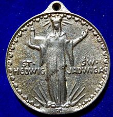
Upper Silesia Plebiscite 1921 cast iron campaign medal of the pro- German side. The obverse shows the Bavarian born Saint Hedwig of Silesia.
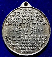
The reverse of this medal states in German and Polish the German origin of the Upper Silesian christianisation.
The Paris Peace Conference at the end of World War I placed some formerly German territory in neighboring countries, some of which had not existed at the beginning of the war. In the case of the new Polish state, the Treaty of Versailles established some 54,000 square kilometers of formerly German territory as part of newly independent Poland. Many of these areas were ethnically mixed. In three of these ethnically mixed areas on the new German-Polish border, however, the Allied leaders provided for border plebiscites or referenda. The areas would be occupied by Allied forces and governed in some degree by Allied commissions. The most significant of these plebiscites was the one in Upper Silesia, since the region was a principal industrial center. The most important economic asset was the enormous coal-mining industry and its ancillary businesses, but the area yielded iron, zinc, and lead as well. The "Industrial Triangle" on the eastern side of the plebiscite zone—between the cities of Beuthen (Bytom), Kattowitz (Katowice), and Gleiwitz (Gliwice) was the heart of this large industrial complex. The Upper Silesia plebiscite was therefore a plebiscite for self-determination of Upper Silesia required by the Treaty of Versailles. Both Germany and Poland valued this region not only for reasons of national feeling, but for its economic importance as well.
The area was occupied by British, French, and Italian forces, and an Interallied Committee headed by a French general, Henri Le Rond. The plebiscite was set for 20 March 1921. Both Poles and Germans were allowed to organize campaigns. Each side developed secret paramilitary forces—both financed from the opposing capitals, Warsaw and Berlin. The major figure of the campaign was Wojciech Korfanty, a pro-Polish politician.
The Poles carried out two uprisings during the campaign, in August 1919 and August 1920. The Allies restored order in each case, but the Polish insurrectionists clashed with German "volunteers," the Freikorps.[9]
A feature of the plebiscite campaign was the growing prominence of a strong autonomist movement, the most visible branch of which was the Bund der Oberschlesier/Związek Górnoślązaków. This organization attempted to gain promises of autonomy from both states and possible future independence for Upper Silesia.[10]
There were 1,186,758 votes cast in an area inhabited by 2,073,663 people.[11] It resulted in 717,122 votes being cast for Germany and 483,514 for Poland. The towns and most of the villages in the plebiscite territory gave German majorities. However, the districts of Pless (Pszczyna) and Rybnik in the southeast, as well as Tarnowitz (Tarnowskie Góry) in the east and Tost-Gleiwitz (Gliwice) in the interior showed considerable Polish majorities, while in Lublinitz (Lubliniec) and Groß Strehlitz (Strzelce Opolskie) the votes cast on either side were practically equal. All the districts of the industrial zone in a narrower sense - Beuthen (Bytom), Hindenburg (Zabrze), Kattowitz (Katowice), and Königshütte (Chorzów) - had slight German majorities, though in Beuthen and Kattowitz this was due entirely to the town vote (four fifth in Kattowitz compared to an overall 60%).[12] Many country communes of Upper Silesia had given Polish majorities. Overall, however, the
Germans won the vote by a measure of 59.4% to 40.6%.[13] This meant that a large percentage of persons of Polish heritage or ethnicity voted for Germany. The Interallied Commission deliberated, but the British proposed a more easterly border than the French, which would have given much less of the Industrial Triangle to Poland.
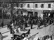
A crowd awaits the plebiscite results in Oppeln (Opole)

1920 special passport issued to those living in the region during the Upper Silesian plebiscite.
In late April 1921, when pro-Polish forces began to fear that the region would be partitioned according to the British plan, elements on the Polish side announced a popular uprising. Korfanty was the leading figure of the uprising, but he had much support in Upper Silesia as well as support from the Polish government in Warsaw. Korfanty called for a popular armed uprising whose aim was to maximize the territory Poland would receive in the partition. German volunteers rushed to meet this uprising, and fighting on a large scale took place in the late spring and early summer of 1921. Germanophone spokesmen and German officials complained that the French units of the Upper Silesian army of occupation were favoring the insurrection by refusing to put down their violent activities or restore order.
Twelve days after the start of the uprising, Wojciech Korfanty offered to take his Upper Silesian forces behind a line of demarcation, on condition that the released territory would not be occupied by German forces, but by Allied troops. On 1 July 1921 British troops returned to Upper Silesia to help French forces occupy this area. Simultaneously with these events, the Interallied Commission pronounced a general amnesty for the illegal actions committed during the recent violence, with the exception of acts of revenge and cruelty. The German defense force was finally withdrawn.
Because the Allied Supreme Council was unable to come to an agreement on the partition of the Upper Silesian territory on the basis of the confusing plebiscite results, a solution was found by turning the question over to the Council of the League of Nations. Agreements between the Germans and Poles in Upper Silesia and appeals issued by both sides, as well as the dispatch of six battalions of Allied troops and the disbandment of the local guards, contributed markedly to the pacification of the district. On the basis of the reports of a League commission and those of its experts, the Council awarded the greater part of the Upper Silesian industrial district to Poland. Poland obtained almost exactly half of the 1,950,000 inhabitants, viz., 965,000, but not quite a third of the territory, i.e., only 3,214.26 km² (1,255 mi²) out of 10,950.89 km² (4,265 mi²) but more than 80% of the heavy industry of the region.[14]
The German and Polish governments, under a League of Nations recommendation, agreed to enforce protections of minority interests that would last for 15 years. Special measures were threatened in case either of the two states should refuse to participate in the drawing up of such regulations, or to accept them subsequently. In the event, the German minority remaining on the Polish side of the border suffered considerable discrimination in the subsequent decades.[15]
The Polish Government, convinced by the economic and political power of the region and by the autonomist movement of the plebiscite campaign, decided to give Upper Silesia considerable autonomy with a Silesian Parliament as a constituency and the Silesian Voivodship Council as the executive body. On the German side the new Prussian province of Upper Silesia (Oberschlesien) with regional government in Oppeln was formed, likewise with special autonomy.
Results
| County | population (1919) | registered voters | turnout | votes for Germany | % | votes for Poland | % |
|---|---|---|---|---|---|---|---|
Beuthen (Bytom), town [16] | 71,187 | 42,990 | 39,991 | 29,890 | 74.7% | 10,101 | 25.3% |
Beuthen (Bytom), district [16] | 213,790 | 109,749 | 106,698 | 43,677 | 40.9% | 63,021 | 59.1% |
Cosel (Koźle), district [17] | 79,973 | 51,364 | 50,100 | 37,651 | 75.2% | 12,449 | 24.8% |
Gleiwitz (Gliwice), town [18] | 69,028 | 41,949 | 40,587 | 32,029 | 78.9% | 8,558 | 21.1% |
Groß Strehlitz (Strzelce Opolskie), district [19] | 76,502 | 46,528 | 45,461 | 22,415 | 49.3% | 23,046 | 50.7% |
Hindenburg (Zabrze), district [20] | 167,632 | 90,793 | 88,480 | 45,219 | 51.1% | 43,261 | 48.9% |
Kattowitz (Katowice), town [21] | 45,422 | 28,531 | 26,674 | 22,774 | 85.4% | 3,900 | 14.6% |
Kattowitz (Katowice), district [21] | 227,657 | 122,342 | 119,011 | 52,892 | 44.4% | 66,119 | 55.6% |
Königshütte (Chorzów), town [22] | 74,811 | 44,052 | 42,628 | 31,864 | 74.7% | 10,764 | 25.3% |
Kreuzburg (Kluczbork), district [23] | 52,558 | 40,602 | 39,627 | 37,975 | 95.8% | 1,652 | 4.2% |
Leobschütz (Głubczyce), district [24] | 78,247 | 66,697 | 65,387 | 65,128 | 99.6% | 259 | 0.4% |
Lublinitz (Lubliniec), district [25] | 55,380 | 29,991 | 29,132 | 15,453 | 53.0% | 13,679 | 47.0% |
Namslau (Namysłów), district [26] | 5,659 | 5,606 | 5,481 | 5,348 | 97.6% | 133 | 2.4% |
Neustadt (Prudnik), district [27] | 51,287 | 36,941 | 36,093 | 31,825 | 88.2% | 4,268 | 11.8% |
Oppeln (Opole), town [28] | 35,483 | 22,930 | 21,914 | 20,816 | 95.0% | 1,098 | 5.0% |
Oppeln (Opole), district [28] | 123,165 | 82,715 | 80,896 | 56,170 | 69.4% | 24,726 | 30.6% |
Pleß (Pszczyna), district [29] | 141,828 | 73,923 | 72,053 | 18,675 | 25.9% | 53,378 | 74.1% |
Ratibor (Racibórz), town [30] | 36,994 | 25,336 | 24,518 | 22,291 | 90.9% | 2,227 | 9.1% |
Ratibor (Racibórz), district [30] | 78,238 | 45,900 | 44,867 | 26,349 | 58.7% | 18,518 | 41.3% |
Rosenberg (Olesno), district [31] | 54,962 | 35,976 | 35,007 | 23,857 | 68.1% | 11,150 | 31.9% |
Rybnik, district [32] | 160,836 | 82,350 | 80,266 | 27,919 | 34.8% | 52,347 | 65.2% |
Tarnowitz (Tarnowskie Góry), district [33] | 86,563 | 45,561 | 44,591 | 17,078 | 38.3% | 27,513 | 61.7% |
Tost-Gleiwitz (Gliwice), district [18] | 86,461 | 48,153 | 47,296 | 20,098 | 42.5% | 27,198 | 57.5% |
Total [34] | 2,073,663 | 1,220,979 | 1,186,758 | 707,393 | 59.6% | 479,365 | 40.4% |
| Without Namslau district [13] | 2,068,004 | 1,215,373 | 1,181,277 | 702,045 | 59.4% | 479,232 | 40.6% |
According to Article 88 of the Treaty of Versailles all inhabitants of the plebiscite district older than 20 years of age and those who had "been expelled by the German authorities and have not retained their domicile there" were entitled to return to vote.
This stipulation of the Treaty of Versailles allowed the participation of thousands of Upper Silesian migrant workers from western Germany (Ruhrpolen). Hugo Service regards the transport of these eligible voters to Silesia, organized by German authorities, "a cynical act aimed at boosting the German vote", in his opinion it was one of the reasons for the overall result. As Service writes, despite the fact that almost 60% of Upper Silesians voted for their region to remain part of Germany it would be dubious to claim that most of them were ethnically German or regarded themselves as Germans. Voting for Germany in the 1921 vote and regarding oneself as German were two different things. People had diverse, often very pragmatic reasons for voting for Germany, which usually had little to do with a person regarding him or herself as having a German ethnonational identity.[35][36]
Settlements which voted to secede for Poland
In the 1921 plebiscite 40.6% of eligible voters (people over 20 years old – a high minimum age that favoured the German-speaking part of the population, whose median age was greater than that of Polish-speakers in Upper Silesia, according to censuses of 1900–1910) decided to secede from Germany and become Polish citizens.[13]
In total over seven hundred towns and villages voted in majority to secede from Germany and become part of Poland, especially in the counties of Pszczyna,[29]Rybnik,[32]Tarnowskie Góry,[33]Toszek-Gliwice,[18]Strzelce Opolskie,[19]Bytom,[16]Katowice,[21]Lubliniec,[25]Zabrze,[20]Racibórz,[30]Olesno,[31]Koźle[17] and Opole.[28]
Hlučín region
The Hlučín Region (German: Hultschiner Ländchen), the southern part of Ratibor district shown in lilac in the map, had a Czech-speaking majority. On 4 February 1920 it had been handed over without a referendum to Czechoslovakia, according to Article 83 of the Treaty of Versailles. It was not involved in the plebiscite.
See also
| Wikimedia Commons has media related to Upper Silesia plebiscite. |
- Territorial changes of Germany after World War I
- Territorial changes of Poland after World War I
- East Prussian plebiscite
References
^ T. Hunt Tooley, "National Identity and Weimar Germany: Upper Silesia and the eastern border", University of Nebraska Press, 1997, p. 140
^ Racisms Made in Germany edited by Wulf D. Hund, Wulf Dietmar Hund, Christian Koller, Moshe Zimmermann LIT Verlag Münster 2011 page 20, 21
^ The Ideology of Kokugo: Nationalizing Language in Modern Japan Lee Yeounsuk page 161 University of Hawaii Press 2009
^ The Immigrant Threat: The Integration of Old and New Migrants in Western Europe since 1850 (Studies of World Migrations) Leo Lucassen page 61 University of Illinois Press page 2005
^ Joseph Partsch (1896). "Die Sprachgrenze 1790 und 1890". Schlesien: eine Landeskunde für das deutsche Volk. T. 1., Das ganze Land (in German). Breslau: Verlag Ferdinand Hirt. pp. 364–367..mw-parser-output cite.citation{font-style:inherit}.mw-parser-output q{quotes:"""""""'""'"}.mw-parser-output code.cs1-code{color:inherit;background:inherit;border:inherit;padding:inherit}.mw-parser-output .cs1-lock-free a{background:url("//upload.wikimedia.org/wikipedia/commons/thumb/6/65/Lock-green.svg/9px-Lock-green.svg.png")no-repeat;background-position:right .1em center}.mw-parser-output .cs1-lock-limited a,.mw-parser-output .cs1-lock-registration a{background:url("//upload.wikimedia.org/wikipedia/commons/thumb/d/d6/Lock-gray-alt-2.svg/9px-Lock-gray-alt-2.svg.png")no-repeat;background-position:right .1em center}.mw-parser-output .cs1-lock-subscription a{background:url("//upload.wikimedia.org/wikipedia/commons/thumb/a/aa/Lock-red-alt-2.svg/9px-Lock-red-alt-2.svg.png")no-repeat;background-position:right .1em center}.mw-parser-output .cs1-subscription,.mw-parser-output .cs1-registration{color:#555}.mw-parser-output .cs1-subscription span,.mw-parser-output .cs1-registration span{border-bottom:1px dotted;cursor:help}.mw-parser-output .cs1-hidden-error{display:none;font-size:100%}.mw-parser-output .cs1-visible-error{font-size:100%}.mw-parser-output .cs1-subscription,.mw-parser-output .cs1-registration,.mw-parser-output .cs1-format{font-size:95%}.mw-parser-output .cs1-kern-left,.mw-parser-output .cs1-kern-wl-left{padding-left:0.2em}.mw-parser-output .cs1-kern-right,.mw-parser-output .cs1-kern-wl-right{padding-right:0.2em}
^ Georg Hassel (1823). Statistischer Umriß der sämmtlichen europäischen und der vornehmsten außereuropäischen Staaten, in Hinsicht ihrer Entwickelung, Größe, Volksmenge, Finanz- und Militärverfassung, tabellarisch dargestellt; Erster Heft: Welcher die beiden großen Mächte Österreich und Preußen und den Deutschen Staatenbund darstellt (in German). Verlag des Geographischen Instituts Weimar. p. 34.Nationalverschiedenheit 1819: Polen - 377,100; Deutsche - 162,600; Mährer - 12,000; Juden - 8,000; Tschechen - 1,600; Gesamtbevölkerung: 561,203
^ abcdefghij Paul Weber (1913). Die Polen in Oberschlesien: eine statistische Untersuchung (in German). Berlin: Verlagsbuchhandlung von Julius Springer. pp. 8–9.
^ abcd Paul Weber (1913). Die Polen in Oberschlesien: eine statistische Untersuchung (in German). Berlin: Verlagsbuchhandlung von Julius Springer. p. 27.
^ T. Hunt Tooley, "German Political Violence and the Border Plebiscite in Upper Silesia, 1919-1921," Central European History 21 (March 1988): 56-98.
^ Günter Doose, Die separatistische Bewegung in Oberschlesien nach dem ersten Weltkrieg. Wiesbaden: Harrassowitz, 1987
^ herder-institut.de: (in German)(in French)(in Polish) Results of the plebiscites in three Prussian districts conducted between July 1920 and March 1921, according to Polish sources. "Rocznik statystyki Rzeczypospolitej Polskiej" (PDF). Główny Urząd Statystyczny Rzeczypospolitej Polskiej GUS, Annual (Main Statistical Office of the Republic of Poland). 1920. Archived from the original (pdf) on 2013-07-22. Retrieved 2012-06-08. - Also in HTML
^ Urban, Thomas (2003). Polen (2 ed.). C.H.Beck. p. 40. ISBN 3-406-44793-7. Retrieved 2008-08-28.
^ abc Volksabstimmungen in Oberschlesien 1920-1922 (gonschior.de)
^ Karl Junge, 1922, "Foreign and colonial history: Germany and Austria (Ch.III), Germany," in The Annual Register: A Review of Public Events at Home and Abroad, for the Year 1921 (M. Epstein, Ed.), pp. 177-186, esp. 179f, New Yprk, NY, USA: Longmans, Green, and Co., see [1], accessed 6 July 2015.
^ Richard Blanke, Orphans of Versailles: The Germans in Western Poland, 1918-1939. Lexington, KY: The University of Kentucky Press, 1993.
^ abc Die Volksabstimmung in Oberschlesien 1921: Beuthen
^ ab Die Volksabstimmung in Oberschlesien 1921: Cosel Archived 2016-03-04 at the Wayback Machine.
^ abc Die Volksabstimmung in Oberschlesien 1921: Gleiwitz und Tost Archived 2016-03-04 at the Wayback Machine.
^ ab Die Volksabstimmung in Oberschlesien 1921: Groß Strehlitz Archived 2016-03-04 at the Wayback Machine.
^ ab Die Volksabstimmung in Oberschlesien 1921: Hindenburg
^ abc Die Volksabstimmung in Oberschlesien 1921: Kattowitz Archived 2016-03-04 at the Wayback Machine.
^ Die Volksabstimmung in Oberschlesien 1921: Königshütte
^ Die Volksabstimmung in Oberschlesien 1921: Kreuzburg
^ Die Volksabstimmung in Oberschlesien 1921: Leobschütz
^ ab Die Volksabstimmung in Oberschlesien 1921: Lublinitz Archived 2016-03-04 at the Wayback Machine.
^ Die Volksabstimmung in Oberschlesien 1921: Namslau
^ Die Volksabstimmung in Oberschlesien 1921: Neustadt Archived 2016-03-04 at the Wayback Machine.
^ abc Die Volksabstimmung in Oberschlesien 1921: Oppeln Archived 2016-03-04 at the Wayback Machine.
^ ab Die Volksabstimmung in Oberschlesien 1921: Pless Archived 2015-05-02 at the Wayback Machine.
^ abc Die Volksabstimmung in Oberschlesien 1921: Ratibor Archived 2016-03-04 at the Wayback Machine.
^ ab Die Volksabstimmung in Oberschlesien 1921: Rosenberg Archived 2016-03-04 at the Wayback Machine.
^ ab Die Volksabstimmung in Oberschlesien 1921: Rybnik Archived 2016-03-04 at the Wayback Machine.
^ ab Die Volksabstimmung in Oberschlesien 1921: Tarnowitz Archived 2014-02-01 at the Wayback Machine.
^ Herder Institut (in German)
^ Service, Hugo (2013). Germans to Poles. Cambridge University Press. ISBN 978-1-107-67148-5.
^ Tooley, T. Hunt. National Identity and Weimar Germany: Upper Silesia and the Eastern Border, 1918-1922 University of Nebraska Press 1997,
ISBN 978-0803244290, p. 234-252
.mw-parser-output .refbegin{font-size:90%;margin-bottom:0.5em}.mw-parser-output .refbegin-hanging-indents>ul{list-style-type:none;margin-left:0}.mw-parser-output .refbegin-hanging-indents>ul>li,.mw-parser-output .refbegin-hanging-indents>dl>dd{margin-left:0;padding-left:3.2em;text-indent:-3.2em;list-style:none}.mw-parser-output .refbegin-100{font-size:100%}
- Czesław Madajczyk, Tadeusz Jędruszczak, Plebiscyt i trzecie powstanie śląskie ("Plebiscite and Third Silesian Uprising") [in:] Historia Polski ("History of Poland"), Vol.IV, part 1, PAN, Warszawa 1984
ISBN 83-01-03865-9
- Kazimierz Popiołek, Historia Śląska od pradziejów do 1945 roku ("History of Poland since prehistory until 1945"), Śląski Inst. Naukowy (Silesian Science Institute) 1984
ISBN 83-216-0151-0
- T. Hunt Tooley, National Identity and Weimar Germany: Upper Silesia and the Eastern Border, 1918-1922. Lincoln, NE: The University of Nebraska Press, 1997.
- T. K. Wilson, "Frontiers of Violence: Conflict and Identity in Ulster and Upper Silesia 1918-1922". London: Oxford University Press, 2010.
External links
- Wojciech Korfanty's proclamation after plebiscite
Exact plebiscite results - according to villages and districts (in German)- 1920 map showing German territory's changes, including marked area for the Upper Silesia plebiscite
- Map of interwar Poland; shows plebiscite areas
Map of interwar Poland; shows plebiscite areas (in color, Polish)
Silesia topics | |||||||||||||||||||||||||||||
|---|---|---|---|---|---|---|---|---|---|---|---|---|---|---|---|---|---|---|---|---|---|---|---|---|---|---|---|---|---|
| |||||||||||||||||||||||||||||
| |||||||||||||||||||||||||||||
| |||||||||||||||||||||||||||||
| |||||||||||||||||||||||||||||
| |||||||||||||||||||||||||||||
| |||||||||||||||||||||||||||||


Comments
Post a Comment