 Mixing
Salmon River (Idaho)
| Salmon River | |
|---|---|
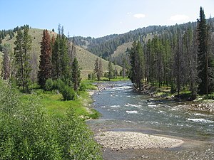 Salmon River in Sawtooth NRA | |
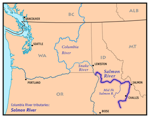 Map of the Salmon River, showing its tributary Middle Fork Salmon River, and its connection to the Columbia River via the Snake River | |
| Nickname(s) | River of No Return |
| Location | |
| Country | United States |
| State | Idaho |
| Cities | Salmon, Challis |
| Physical characteristics | |
| Source | Sawtooth Range |
| - location | near Norton Peak, Lemhi County |
| - coordinates | 43°47′48″N 114°46′36″W / 43.79667°N 114.77667°W / 43.79667; -114.77667[2] |
| - elevation | 9,220 ft (2,810 m)[1] |
| Mouth | Snake River |
- location | west of White Bird, Idaho and Nez Perce Counties |
- coordinates | 45°51′23″N 116°47′37″W / 45.85639°N 116.79361°W / 45.85639; -116.79361Coordinates: 45°51′23″N 116°47′37″W / 45.85639°N 116.79361°W / 45.85639; -116.79361[2] |
- elevation | 919 ft (280 m)[2] |
| Length | 425 mi (684 km)[3] |
| Basin size | 14,000 sq mi (36,000 km2) |
| Discharge | |
| - location | White Bird[4] |
| - average | 11,100 cu ft/s (83,000 US gal/s; 310 m3/s)[5] |
| - minimum | 1,000 cu ft/s (7,500 US gal/s; 28 m3/s) |
| - maximum | 129,000 cu ft/s (960,000 US gal/s; 3,700 m3/s) |
| Basin features | |
| Tributaries | |
| - left | Yankee Fork, Panther Creek, Middle Fork Salmon River, South Fork Salmon River, Little Salmon River |
| - right | East Fork Salmon River, Pahsimeroi River, Lemhi River, North Fork Salmon River |
National Wild and Scenic River | |
| Type | Wild, Recreational |
| Designated | July 23, 1980 |
The Salmon River is located in Idaho in the northwestern United States. The Salmon is also known as "The River of No Return". It flows for 425 miles (685 km) through central Idaho, draining a rugged, thinly populated watershed of 14,000 square miles (36,000 km2) and dropping more than 7,000 feet (2,100 m) between its headwaters, near Galena Summit above the Sawtooth Valley in the Sawtooth National Recreation Area, and its confluence with the Snake River. Measured at White Bird, its average discharge is 11,060 cubic feet per second (82,700 US gal/s; 313 m3/s).[6] It is one of the largest rivers in the continental United States without a single dam on its mainstem.[7]
Cities located along the Salmon River include Stanley, Clayton, Challis, Salmon, Riggins, and White Bird. Redfish Lake and Little Redfish Lake near Stanley, which flow into the river via Redfish Lake Creek, are the terminus of the longest Pacific sockeye salmon migration in North America.[8]
The lower half of the river provides the time zone boundary for the state, with northern Idaho on Pacific time and the rest of the state on Mountain time.
Contents
1 Course
2 History
2.1 Anthropology
2.2 Exploration
2.3 Gold
3 Recreation
4 Wildlife
5 USGS stations
6 Gallery
7 See also
8 References
9 External links
Course
The Salmon River originates from and flows through the mountains of central and eastern Idaho (Lemhi Range, Sawtooth, Salmon River Mountains, Clearwater and Bitterroot Range). The main stem rises in the Sawtooth Range at over 9,200 feet (2,800 m) in elevation, several miles northwest of Norton Peak. For the first 30 miles (50 km), it flows north through the Sawtooth Valley, then turns east at Stanley, receiving the Yankee Fork shortly below that point and the East Fork further downstream. The river then flows northeast, receiving the Pahsimeroi River at Ellis and then the Lemhi River at Salmon, Idaho east of the Lemhi Range.
North of Salmon, the river is joined by the North Fork, before turning west into over 200 miles (320 km) of continuous canyons through the Salmon River and Clearwater Mountains – some of the most rugged and isolated terrain in the contiguous United States. Exhibiting upwards of 7,000 feet (2,130 m) of vertical relief, the Salmon River canyons are some of the deepest in the U.S., surpassing the Grand Canyon and second only to the Snake River's Hells Canyon on the Idaho–Oregon border.[9] Here, the river is joined by its two largest tributaries, the Middle Fork and South Fork. Ten miles (16 km) downstream (west) of its confluence with the Middle Fork, the Salmon River becomes the dividing line for the two time zones in Idaho: Mountain time to the south, Pacific time to the north, bisecting the state at approximately 45½ degrees north latitude.
The river turns abruptly north at the confluence with the Little Salmon River at Riggins, about 87 miles (140 km) above its mouth. From there the river flows almost due north, with U.S. Route 95 on its east bank until a few miles before White Bird; the river then loops northwest and south to its confluence with the Snake River north of Hells Canyon, 15 miles (25 km) south of the Washington border and 40 miles (65 km) south of Lewiston. The Salmon River is the longest river system contained entirely within a single U.S. state.[7]
History
Anthropology
The Salmon River area has been home to people for at least the last 8,000 years.[10] Much of the area was inhabited by several tribes, including the Nez Perce. The river was considered sacred ground and a rich source of food for the indigenous people of the area, who relied on the abundant salmon species and other wildlife.
Exploration

Columbia River Basin
In August 1805, just after crossing the Continental Divide of the Americas, Lewis and Clark ventured down the Salmon River, but found it to be too rough to be navigable. Clark wrote:
... I shall in justice to Capt. Lewis who was the first white man ever on this fork of the Columbia Call this Louis's river. ... The Westerly fork of the Columbia River [the present Salmon River] is double the size of the Easterley fork [the present Lemhi River] & below those forks the river is ... 100 yards [90 m] wide, it is very rapid & Sholey water Clear but little timber.[11]
The honor didn't last long; by 1810, maps of the area were already referring to "Louis' River" as the Salmon. Clark had thought that the Salmon River was the Snake River, thus he called it the "Westerly fork of the Columbia". The Snake River retained the variant name "Lewis River" or "Lewis Fork" longer than did the Salmon.
Gold
In the 1860s, placer deposits of gold were found along the river, and a gold rush began. Miners came to the area, causing clashes with the Nez Perce on their ancestral tribal lands. Many historic and present day mines (including dredging operations) can be seen while traveling along the river.
Recreation

Salmon River and Sawtooth Mountains from Lower Stanley
Several national forests and Sawtooth National Recreation Area provide for numerous recreation opportunities within the river's watershed. Two segments (the Middle Fork and a section of the main Salmon River, known as the Main Fork) are protected as National Wild and Scenic Rivers. The Middle Fork was one of the original eight rivers designated Wild and Scenic in 1968, and is often considered the "crown jewel"[7] of the Wild and Scenic system.[12]
The Salmon is a popular destination for whitewater kayaking, canoeing, and rafting. The canyons of the Salmon allow for magnificent views of the complex geology of the region. The Frank Church-River of No Return Wilderness Area includes one of the deepest canyons in the continental United States, which at roughly 7,000 feet (2,130 m) of vertical relief, is deeper than the Grand Canyon.
Both the Middle Fork and Main Fork travel through the Frank Church-River of No Return Wilderness Area. The Middle Fork is about 110 miles (180 km) long, while the Main Fork is about 81 miles (130 km) in length. The Middle Fork raft trip run ends 7 miles (11 km) prior to the beginning of the Main Fork run; Corn Creek is the start of the Main Fork section of the Salmon River.
The South Fork of the Salmon flows through Payette National Forest and enters the Wild and Scenic Main Fork at Mackay Bar. The Main Fork raft trip ends about 25 miles (40 km) east of Riggins, either at Vinegar Creek or Carey Creek, marking the beginning of the Lower Salmon rafting section. Boating companies offer both single and multiple day trips on the river.
The Middle Fork of the Salmon River is known as one of the best catch and release fly fisheries in the nation. Other recreational activities along the river include camping, hiking and mountain biking.
Wildlife
The Salmon River historically produced 45% percent of all the steelhead (ocean-going rainbow trout) and 45 percent of all the spring and summer chinook salmon in the entire Columbia River Basin. The Salmon River basin contains most (up to 70 percent) of the remaining salmon and steelhead habitat in the Columbia River Basin. Despite abundant, excellent salmon habitat in the Salmon River basin, chinook, steelhead, and sockeye salmon populations have not significantly recovered, despite listings under the federal Endangered Species Act since the mid-1990s. Populations remain at risk in large part because of the negative effects of four federal dams and reservoirs on the lower Snake river, through which both juvenile salmon and returning adults must pass. Many Northwest salmon advocates, commercial & sportfishermen call for removal of the Lower Granite, Little Goose, Lower Monumental, and Ice Harbor dams to address survival problems. As of November 2015, controversy continues in NW Politics, public discourse, and in federal court, where federal salmon recovery plans are under legal challenge.[13][citation needed]
USGS stations
The United States Geological Survey operates four stream gauge water level monitoring stations on the main stem of the Salmon River and 17 others on its tributaries. Real time data is available for each station on the USGS website. For a map of these see Salmon River USGS Station Map or in the box at right.
| Stream | Location | Site number | Coordinates | Drainage area | Avg discharge | Max discharge | Min discharge | Website |
|---|---|---|---|---|---|---|---|---|
| Salmon River | Clayton, ID | 13296500 | 44°16′06″N 114°43′58″W / 44.26833°N 114.73278°W / 44.26833; -114.73278 (Salmon River below Yankee Fork near Clayton, ID) | 807 sq mi (2,090 km2) | 974 cu ft/s (27.6 m3/s) | 10,400 cu ft/s (290 m3/s) | 160 cu ft/s (4.5 m3/s) | [1] |
| Salmon River | Salmon, ID | 13302500 | 45°11′01″N 113°53′43″W / 45.18361°N 113.89528°W / 45.18361; -113.89528 (Salmon River at Salmon, ID) | 3,737 sq mi (9,680 km2) | 1,923 cu ft/s (54.5 m3/s) | 17,700 cu ft/s (500 m3/s) | 242 cu ft/s (6.9 m3/s) | [2] |
| Salmon River | Shoup, ID | 13307000 | 45°19′21″N 114°26′24″W / 45.32250°N 114.44000°W / 45.32250; -114.44000 (Salmon River near Shoup, ID) | 6,239 sq mi (16,160 km2) | 2,913 cu ft/s (82.5 m3/s) | 25,700 cu ft/s (730 m3/s) | 600 cu ft/s (17 m3/s) | [3] |
| Salmon River | White Bird, ID | 13317000 | 45°45′01″N 116°19′26″W / 45.75028°N 116.32389°W / 45.75028; -116.32389 (Salmon River at White Bird, ID) | 13,421 sq mi (34,760 km2) | 11,090 cu ft/s (314 m3/s) | 130,000 cu ft/s (3,700 m3/s) | 1,000 cu ft/s (28 m3/s) | [4] |
| Valley Creek | Stanley, ID | 13295000 | 44°13′21″N 114°55′52″W / 44.22250°N 114.93111°W / 44.22250; -114.93111 (Valley Creek at Stanley, ID) | 147 sq mi (380 km2) | 198 cu ft/s (5.6 m3/s) | 2,210 cu ft/s (63 m3/s) | 34 cu ft/s (0.96 m3/s) | [5] |
| Yankee Fork Salmon River | Clayton, ID | 13296000 | 44°16′44″N 114°44′02″W / 44.27889°N 114.73389°W / 44.27889; -114.73389 (Yankee Fork Salmon River near Clayton, ID) | 189 sq mi (490 km2) | 198 cu ft/s (5.6 m3/s) | 3,360 cu ft/s (95 m3/s) | 10 cu ft/s (0.28 m3/s) | [6] |
| Thompson Creek | Clayton, ID | 13297330 | 44°16′13″N 114°31′00″W / 44.27028°N 114.51667°W / 44.27028; -114.51667 (Thompson Creek near Clayton, ID) | 29.1 sq mi (75 km2) | 16.8 cu ft/s (0.48 m3/s) | 442 cu ft/s (12.5 m3/s) | 1.0 cu ft/s (0.028 m3/s) | [7] |
| Squaw Creek | Clayton, ID | 13297355 | 44°17′27″N 114°28′18″W / 44.29083°N 114.47167°W / 44.29083; -114.47167 (Squaw Creek below Bruno Creek near Clayton, ID) | 71.6 sq mi (185 km2) | 33.2 cu ft/s (0.94 m3/s) | 755 cu ft/s (21.4 m3/s) | 3.3 cu ft/s (0.093 m3/s) | [8] |
Pahsimeroi River | Ellis, ID | 13302005 | 44°41′30″N 114°02′49″W / 44.69167°N 114.04694°W / 44.69167; -114.04694 (Pahsimeroi River at Ellis, ID) | 830 sq mi (2,100 km2) | 230 cu ft/s (6.5 m3/s) | 710 cu ft/s (20 m3/s) | 87 cu ft/s (2.5 m3/s) | [9] |
Lemhi River | Lemhi, ID | 13305000 | 44°56′24″N 113°38′21″W / 44.94000°N 113.63917°W / 44.94000; -113.63917 (Lemhi River near Lemhi, ID) | 897 sq mi (2,320 km2) | 257 cu ft/s (7.3 m3/s) | 2,430 cu ft/s (69 m3/s) | 22 cu ft/s (0.62 m3/s) | [10] |
Lemhi River | Salmon, ID | 13305310 | 45°07′58″N 113°47′56″W / 45.13278°N 113.79889°W / 45.13278; -113.79889 (Lemhi River below L5 Diversion near Salmon, ID) | 1,216 sq mi (3,150 km2) | 258 cu ft/s (7.3 m3/s) | 2,920 cu ft/s (83 m3/s) | 0.75 cu ft/s (0.021 m3/s) | [11] |
| Blackbird Creek | Cobalt, ID | 13306336 | 45°05′29″N 114°17′53″W / 45.09139°N 114.29806°W / 45.09139; -114.29806 (Blackbird Creek near Cobalt, ID) | Unknown | 6.8 cu ft/s (0.19 m3/s) | 100 cu ft/s (2.8 m3/s) | 2 cu ft/s (0.057 m3/s) | [12] |
| Panther Creek | Cobalt, ID | 13306370 | 45°05′23″N 114°14′12″W / 45.08972°N 114.23667°W / 45.08972; -114.23667 (Panther Creek at Cobalt, ID) | Unknown | 57.6 cu ft/s (1.63 m3/s) | 1,100 cu ft/s (31 m3/s) | 3.5 cu ft/s (0.099 m3/s) | [13] |
| Napias Creek | Leesburg, ID | 13306385 | 45°12′20″N 114°08′02″W / 45.20556°N 114.13389°W / 45.20556; -114.13389 (Napias Creek below Arnett Creek near Leesburg, ID) | 41.1 sq mi (106 km2) | 29.2 cu ft/s (0.83 m3/s) | 1,020 cu ft/s (29 m3/s) | 3.5 cu ft/s (0.099 m3/s) | [14] |
Middle Fork Salmon River | Yellow Pine, ID | 13309220 | 44°43′18″N 115°00′59″W / 44.72167°N 115.01639°W / 44.72167; -115.01639 (Middle Fork Salmon River at Middle Fork Lodge near Yellow Pine, ID) | 1,042 sq mi (2,700 km2) | 1,413 cu ft/s (40.0 m3/s) | 20,900 cu ft/s (590 m3/s) | 190 cu ft/s (5.4 m3/s) | [15] |
Middle Fork Salmon River | Shoup, ID | 13310199 | 45°17′37″N 114°35′47″W / 45.29361°N 114.59639°W / 45.29361; -114.59639 (Middle Fork Salmon River at mouth near Shoup, ID) | 2,876 sq mi (7,450 km2) | 2,818 cu ft/s (79.8 m3/s) | 28,600 cu ft/s (810 m3/s) | 349 cu ft/s (9.9 m3/s) | [16] |
| South Fork Salmon River | Krassel Ranger Station | 13310700 | 44°59′13″N 115°43′30″W / 44.98694°N 115.72500°W / 44.98694; -115.72500 (South Fork Salmon River near Krassel Ranger Station, ID) | 330 sq mi (850 km2) | 535 cu ft/s (15.1 m3/s) | 9,710 cu ft/s (275 m3/s) | 38 cu ft/s (1.1 m3/s) | [17] |
| East Fork South Fork Salmon River | Stibnite, ID | 13311000 | 44°54′21″N 115°19′42″W / 44.90583°N 115.32833°W / 44.90583; -115.32833 (East Fork South Fork Salmon River at Stibnite, ID) | 19.3 sq mi (50 km2) | 25.6 cu ft/s (0.72 m3/s) | 394 cu ft/s (11.2 m3/s) | 2.0 cu ft/s (0.057 m3/s) | [18] |
| Sugar Creek | Stibnite, ID | 13311450 | 44°56′10.9″N 115°20′14.0″W / 44.936361°N 115.337222°W / 44.936361; -115.337222 (Sugar Creek near Stibnite, ID) | Unknown | 22.9 cu ft/s (0.65 m3/s) | 185 cu ft/s (5.2 m3/s) | 5.5 cu ft/s (0.16 m3/s) | [19] |
| Johnson Creek | Yellow Pine, ID | 13313000 | 44°57′42″N 115°30′00″W / 44.96167°N 115.50000°W / 44.96167; -115.50000 (Johnson Creek at Yellow Pine, ID) | 218 sq mi (560 km2) | 344 cu ft/s (9.7 m3/s) | 6,250 cu ft/s (177 m3/s) | 21 cu ft/s (0.59 m3/s) | [20] |
| Little Salmon River | Riggins, ID | 13316500 | 45°24′47″N 116°19′31″W / 45.41306°N 116.32528°W / 45.41306; -116.32528 (Little Salmon River at Riggins, ID) | 576 sq mi (1,490 km2) | 776 cu ft/s (22.0 m3/s) | 12,600 cu ft/s (360 m3/s) | 54 cu ft/s (1.5 m3/s) | [21] |
Gallery

Salmon River, north of Riggins
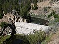
Breached Sunbeam Dam on the Salmon
Yankee Fork of the Salmon
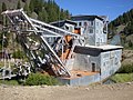
Yankee Fork Gold Dredge
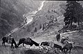
Salmon River Canyon 1945


See also
- List of Idaho rivers
- List of longest streams of Idaho
- List of National Wild and Scenic Rivers
References
^ Google Earth elevation for GNIS source coordinates.
^ abc "Salmon River". Geographic Names Information System. United States Geological Survey. 1979-06-21. Retrieved 2013-12-14..mw-parser-output cite.citation{font-style:inherit}.mw-parser-output .citation q{quotes:"""""""'""'"}.mw-parser-output .citation .cs1-lock-free a{background:url("//upload.wikimedia.org/wikipedia/commons/thumb/6/65/Lock-green.svg/9px-Lock-green.svg.png")no-repeat;background-position:right .1em center}.mw-parser-output .citation .cs1-lock-limited a,.mw-parser-output .citation .cs1-lock-registration a{background:url("//upload.wikimedia.org/wikipedia/commons/thumb/d/d6/Lock-gray-alt-2.svg/9px-Lock-gray-alt-2.svg.png")no-repeat;background-position:right .1em center}.mw-parser-output .citation .cs1-lock-subscription a{background:url("//upload.wikimedia.org/wikipedia/commons/thumb/a/aa/Lock-red-alt-2.svg/9px-Lock-red-alt-2.svg.png")no-repeat;background-position:right .1em center}.mw-parser-output .cs1-subscription,.mw-parser-output .cs1-registration{color:#555}.mw-parser-output .cs1-subscription span,.mw-parser-output .cs1-registration span{border-bottom:1px dotted;cursor:help}.mw-parser-output .cs1-ws-icon a{background:url("//upload.wikimedia.org/wikipedia/commons/thumb/4/4c/Wikisource-logo.svg/12px-Wikisource-logo.svg.png")no-repeat;background-position:right .1em center}.mw-parser-output code.cs1-code{color:inherit;background:inherit;border:inherit;padding:inherit}.mw-parser-output .cs1-hidden-error{display:none;font-size:100%}.mw-parser-output .cs1-visible-error{font-size:100%}.mw-parser-output .cs1-maint{display:none;color:#33aa33;margin-left:0.3em}.mw-parser-output .cs1-subscription,.mw-parser-output .cs1-registration,.mw-parser-output .cs1-format{font-size:95%}.mw-parser-output .cs1-kern-left,.mw-parser-output .cs1-kern-wl-left{padding-left:0.2em}.mw-parser-output .cs1-kern-right,.mw-parser-output .cs1-kern-wl-right{padding-right:0.2em}
^ Salmon River Archived 2007-10-12 at the Wayback Machine, The Columbia Gazetteer of North America
^ "USGS Gage #13317000 on the Salmon River at White Bird, ID" (PDF). National Water Information System. United States Geological Survey. 1910–2012. Retrieved 2013-12-15.
^ "USGS Gage #13317000 on the Salmon River at White Bird, ID" (PDF). National Water Information System. United States Geological Survey. 1910–2012. Retrieved 2013-12-15.
^ http://pubs.usgs.gov/wdr/2005/wdr-id-05-1/ Water Resources Data, Idaho, 2005
^ abc "The Salmon River". Outdoor Idaho. Idaho Public Television. Archived from the original on 2013-12-15. Retrieved 2013-12-14.
^ "Redfish Lake sockeye salmon captive broodstock". Northwest Fisheries Science Center. National Oceanic and Atmospheric Administration. Retrieved 2013-12-14.
^ "Archived copy". Archived from the original on 2013-12-15. Retrieved 2013-12-15.CS1 maint: Archived copy as title (link)
^ "Salmon River, Idaho". National Wild & Scenic Rivers System. Archived from the original on February 21, 2014. Retrieved February 21, 2014.
^ "18 – Forks of Louis's River". Salmon-Challis National Forest – Lewis & Clark Interactive Tour. U. S. Forest Service. Retrieved 2009-01-10.
^ http://www.fs.usda.gov/detail/scnf/recreation/wateractivities/?cid=stelprdb5302105
^ multiple sources, incl. Idaho Dept of Fish and Game, USFS, USFWS.
^ "Current Conditions". United States Geological Survey. Retrieved August 11, 2012.
External links
| Wikimedia Commons has media related to Salmon River (Idaho). |
Salmon River – Salmon River, Info Hub
Visit Idaho.org – Idaho Rivers- Salmon River (National Wild and Scenic Rivers site)
- Middle Fork of the Salmon (National Wild and Scenic Rivers site)
Boise (capital) | ||
| Topics |
|  Seal of Idaho |
| Society |
| |
| Regions |
| |
| Larger cities |
| |
| Smaller cities |
| |
| Counties |
| |


Comments
Post a Comment