 Mixing
West Liberty, Ohio
West Liberty, Ohio | |
|---|---|
Village | |
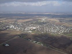 West Liberty from the southeast | |
 Location of West Liberty, Ohio | |
 Detailed map of West Liberty | |
| Coordinates: 40°15′15″N 83°45′27″W / 40.25417°N 83.75750°W / 40.25417; -83.75750Coordinates: 40°15′15″N 83°45′27″W / 40.25417°N 83.75750°W / 40.25417; -83.75750 | |
| Country | United States |
| State | Ohio |
| Counties | Logan |
| Area [1] | |
| • Total | 1.12 sq mi (2.90 km2) |
| • Land | 1.12 sq mi (2.90 km2) |
| • Water | 0 sq mi (0 km2) |
| Population (2010)[2] | |
| • Total | 1,805 |
| • Estimate (2012[3]) | 1,789 |
| • Density | 1,611.6/sq mi (622.2/km2) |
| Time zone | UTC-5 (Eastern (EST)) |
| • Summer (DST) | UTC-4 (EDT) |
| ZIP code | 43357 |
| Area code(s) | 937 |
| Website | http://www.mywestliberty.com/ |
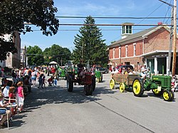
West Liberty's annual antique tractor parade
West Liberty is a village in Logan County, Ohio, United States. The population was 1,805 at the 2010 census.
Contents
1 History
2 Geography
3 Demographics
3.1 2010 census
3.2 2000 census
4 Government
5 Transportation
6 Notable people
7 Attractions
8 References
9 External links
History
West Liberty was laid out in 1817. In 1833, West Liberty contained five stores, two taverns, one tannery, a merchant mill, a saw mill, a carding machine, and about 20 residential houses.[4]
Geography
West Liberty is located at 40°15′15″N 83°45′27″W / 40.25417°N 83.75750°W / 40.25417; -83.75750 (40.254169, -83.757452).[5]
According to the United States Census Bureau, the village has a total area of 1.12 square miles (2.90 km2), all of it land.[1]
Flowing along the edge of town is the Mad River, a major source of running water in the area.
Demographics
| Historical population | |||
|---|---|---|---|
| Census | Pop. | %± | |
| 1850 | 643 | — | |
| 1860 | 916 | 42.5% | |
| 1870 | 741 | −19.1% | |
| 1880 | 715 | −3.5% | |
| 1900 | 1,236 | — | |
| 1910 | 1,288 | 4.2% | |
| 1920 | 1,347 | 4.6% | |
| 1930 | 1,248 | −7.3% | |
| 1940 | 1,228 | −1.6% | |
| 1950 | 1,397 | 13.8% | |
| 1960 | 1,522 | 8.9% | |
| 1970 | 1,580 | 3.8% | |
| 1980 | 1,653 | 4.6% | |
| 1990 | 1,613 | −2.4% | |
| 2000 | 1,813 | 12.4% | |
| 2010 | 1,805 | −0.4% | |
| Est. 2017 | 1,785 | [6] | −1.1% |
| U.S. Decennial Census[7] | |||
2010 census
As of the census[2] of 2010, there were 1,805 people, 736 households, and 436 families residing in the village. The population density was 1,611.6 inhabitants per square mile (622.2/km2). There were 799 housing units at an average density of 713.4 per square mile (275.4/km2). The racial makeup of the village was 96.1% White, 1.3% African American, 0.1% Native American, 0.6% Asian, 0.1% Pacific Islander, 0.2% from other races, and 1.7% from two or more races. Hispanic or Latino of any race were 0.8% of the population.
There were 736 households of which 29.5% had children under the age of 18 living with them, 45.9% were married couples living together, 9.4% had a female householder with no husband present, 3.9% had a male householder with no wife present, and 40.8% were non-families. 37.9% of all households were made up of individuals and 21.2% had someone living alone who was 65 years of age or older. The average household size was 2.26 and the average family size was 3.00.
The median age in the village was 41 years. 25.2% of residents were under the age of 18; 7.8% were between the ages of 18 and 24; 21.5% were from 25 to 44; 22.1% were from 45 to 64; and 23.2% were 65 years of age or older. The gender makeup of the village was 44.6% male and 55.4% female.
2000 census
As of the census[8] of 2000, there were 1,813 people, 660 households, and 432 families residing in the village. The population density was 1,637.7 people per square mile (630.6/km²). There were 698 housing units at an average density of 630.5 per square mile (242.8/km²). The racial makeup of the village was 98.46% White, 0.17% African American, 0.28% Native American, 0.28% Asian, 0.11% Pacific Islander, and 0.72% from two or more races. Hispanic or Latino of any race were 0.17% of the population.
There were 660 households out of which 31.8% had children under the age of 18 living with them, 54.2% were married couples living together, 8.8% had a female householder with no husband present, and 34.4% were non-families. 31.4% of all households were made up of individuals and 13.2% had someone living alone who was 65 years of age or older. The average household size was 2.36 and the average family size was 2.98.
In the village, the population was spread out with 23.2% under the age of 18, 6.4% from 18 to 24, 23.5% from 25 to 44, 19.3% from 45 to 64, and 27.6% who were 65 years of age or older. The median age was 43 years. For every 100 females, there were 76.2 males. For every 100 females age 18 and over, there were 70.2 males.
The median income for a household in the village was $38,819, and the median income for a family was $51,193. Males had a median income of $35,000 versus $26,518 for females. The per capita income for the village was $19,083. About 4.9% of families and 5.3% of the population were below the poverty line, including 6.7% of those under age 18 and 5.0% of those age 65 or over.
Government
A branch of the Logan County District Library serves the West Liberty community.[9]
In the elections of November 2007, Rebecca Hamilton and Greg Hostetler were elected to the village council, and Brad Hudson and Dean King were elected to the village's board of public affairs. Cindee Boyd was elected clerk-treasurer without opposition. No candidate filed for the position of mayor.[10]
Transportation
U.S. Route 68, known as "Detroit Street", forms the main street in West Liberty. Forming the main east-west street is State Route 245, and its intersection with US 68 is one of the primary intersections of the village. At the far northern end of the village, State Route 508 begins from an intersection with US 68 and heads westward to De Graff.
Notable people
Benjamin Piatt Runkle - founder of Sigma Chi
Attractions
- Ohio Caverns
- Piatt Castles
References
^ ab "US Gazetteer files 2010". United States Census Bureau. Retrieved 2013-01-06..mw-parser-output cite.citation{font-style:inherit}.mw-parser-output .citation q{quotes:"""""""'""'"}.mw-parser-output .citation .cs1-lock-free a{background:url("//upload.wikimedia.org/wikipedia/commons/thumb/6/65/Lock-green.svg/9px-Lock-green.svg.png")no-repeat;background-position:right .1em center}.mw-parser-output .citation .cs1-lock-limited a,.mw-parser-output .citation .cs1-lock-registration a{background:url("//upload.wikimedia.org/wikipedia/commons/thumb/d/d6/Lock-gray-alt-2.svg/9px-Lock-gray-alt-2.svg.png")no-repeat;background-position:right .1em center}.mw-parser-output .citation .cs1-lock-subscription a{background:url("//upload.wikimedia.org/wikipedia/commons/thumb/a/aa/Lock-red-alt-2.svg/9px-Lock-red-alt-2.svg.png")no-repeat;background-position:right .1em center}.mw-parser-output .cs1-subscription,.mw-parser-output .cs1-registration{color:#555}.mw-parser-output .cs1-subscription span,.mw-parser-output .cs1-registration span{border-bottom:1px dotted;cursor:help}.mw-parser-output .cs1-ws-icon a{background:url("//upload.wikimedia.org/wikipedia/commons/thumb/4/4c/Wikisource-logo.svg/12px-Wikisource-logo.svg.png")no-repeat;background-position:right .1em center}.mw-parser-output code.cs1-code{color:inherit;background:inherit;border:inherit;padding:inherit}.mw-parser-output .cs1-hidden-error{display:none;font-size:100%}.mw-parser-output .cs1-visible-error{font-size:100%}.mw-parser-output .cs1-maint{display:none;color:#33aa33;margin-left:0.3em}.mw-parser-output .cs1-subscription,.mw-parser-output .cs1-registration,.mw-parser-output .cs1-format{font-size:95%}.mw-parser-output .cs1-kern-left,.mw-parser-output .cs1-kern-wl-left{padding-left:0.2em}.mw-parser-output .cs1-kern-right,.mw-parser-output .cs1-kern-wl-right{padding-right:0.2em}
^ ab "American FactFinder". United States Census Bureau. Retrieved 2013-01-06.
^ "Population Estimates". United States Census Bureau. Retrieved 2013-06-17.
^ Kilbourn, John (1833). "The Ohio Gazetteer, or, a Topographical Dictionary". Scott and Wright. p. 489. Retrieved 12 December 2013.
^ "US Gazetteer files: 2010, 2000, and 1990". United States Census Bureau. 2011-02-12. Retrieved 2011-04-23.
^ "Population and Housing Unit Estimates". Retrieved May 26, 2018.
^ "Census of Population and Housing". Census.gov. Retrieved June 4, 2015.
^ "American FactFinder". United States Census Bureau. Retrieved 2008-01-31.
^ "Branches". Logan County Libraries. Retrieved 26 February 2018.
^ Examiner Staff, The. "Village results", Bellefontaine Examiner, 2007-11-07, p. 2.
External links
| Wikimedia Commons has media related to West Liberty, Ohio. |
- West Liberty home page
- Detailed Logan County map
- Piatt Castles home page
- Ohio Caverns home page
Municipalities and communities of Logan County, Ohio, United States | ||
|---|---|---|
County seat: Bellefontaine | ||
| City |
|  |
| Villages |
| |
| Townships |
| |
| CDPs |
| |
| Unincorporated communities |
| |
| Ghost towns |
| |
| Footnotes | ‡This populated place also has portions in an adjacent county or counties | |


Comments
Post a Comment