 Mixing
Sulaiman Mountains
| Sulaiman Range | |
|---|---|
| د كسي غرونه / کوه سليمان | |
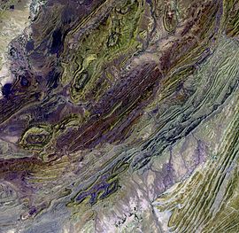 Satellite image of a part of the Sulaiman Range. | |
| Highest point | |
| Elevation | 3,487 m (11,440 ft) |
| Coordinates | 30°30′N 70°10′E / 30.500°N 70.167°E / 30.500; 70.167Coordinates: 30°30′N 70°10′E / 30.500°N 70.167°E / 30.500; 70.167 |
| Geography | |
 Sulaiman Range Location | |
| Location | Zabul, Kandahar and Loya Paktia, Afghanistan South Waziristan, Dera Ismail Khan Subdivision, Balochistan, Punjab and Khyber Pakhtunkhwa, Pakistan |
| Parent range | Hindu Kush |
The Sulaiman Mountains (Pashto: د كسي غرونه; Balochi/Urdu/Persian: کوه سليمان), or Kōh-e Sulaymān, are the southern extension of the Hindu Kush mountain system, located in the Zabul, Kandahar and Loya Paktia regions of Afghanistan, and in South Waziristan, Dera Ismail Khan, most of northern Balochistan, and some parts of southwestern Punjab and Khyber Pakhtunkhwa in Pakistan. The Sulaimans form the eastern edge of the Iranian Plateau where the Indus River separates it from the Indian Subcontinent. Bordering the Sulaimans to the north are the arid highlands of Central Hindu Kush or Paropamisadae, whose heights extend up to 3,383 metres (11,099 ft).
In Frontier Region Dera Ismail Khan, the highest peak of the Sulaimans is Takht-e-Sulaiman or "Throne of Solomon" at 3,487 metres (11,440 ft). In Balochistan, its highest peak is Zarghun Ghar at 3,578 metres (11,739 ft) near Quetta city; while the second-highest is Khilafat Hill at 3,475 metres (11,401 ft) in Ziarat district and is famous for large juniperus macropoda forests in its surroundings.[1]
Contents
1 Geography
2 Legends about Takht-e-Sulaiman
3 See also
4 References
5 External links
Geography
The Sulaiman range runs north in Loya Paktia and meets the Spin Ghar range northeast of Gardez in Paktia province. To the northwest, the Sulaimans merge beyond Loya Paktia into the Koh-i-Baba range. To the east, the Sulaimans enter the districts of Dera Ghazi Khan in Punjab and Dera Ismail Khan in Khyber Pakhtunkhwa, and approaches the Indus River near Mithankot in the Rajanpur District of Punjab. The eastern slopes drop very quickly to the Indus River, but towards west, the mountain range drops gradually in Kandahar southwest into Helmand and the Sistan Basin.
Rivers that flow out from the Sulaimans include the Gomal River which flows eastward into the Indus River, and the Dori River and other small tributaries of the Arghandab River, which flow southwestward into the Helmand River.
The Sulaiman Range, and the high plateau to the west of it, helps form a natural barrier against the humid winds that blow from the Indian Ocean, creating arid conditions across southern and central Afghanistan to the west and north. In contrast, the relatively flat and low-lying Indus delta is situated due east and south of the Sulaimans. This lush delta is prone to heavy flooding and is mostly uncultivated wilderness.[citation needed]
Legends about Takht-e-Sulaiman
In the Pashtun and Gandhara legend, one of the highest peaks of the Takht-i Sulaiman ("Throne of Solomon"), 3,382 metres (11,096 ft) high, is associated with Prophet Solomon. Ibn Battuta names it Koh-i Sulaiman.[2] It is related that Prophet Solomon climbed this mountain and looked out over the land of South Asia, which was then covered with darkness, but he turned back without descending into this new frontier, and left only the mountain which is named after him (from Ibn Battuta).[3] According to another legend, Noah's Ark alighted in the Takht-i Sulaiman after the Deluge.
One legend says that Qais Abdur Rashid, said to be the legendary ancestor of the Pashtun nation, is buried on top of Takht-e-Sulaiman, locally known as Da Kasī Ghar (د کسي غر, "Mount of Qais"), located near the village of Darazinda in Dera Ismail Khan Subdivision of Khyber Pakhtunkhwa, close to the border with both South Waziristan and Zhob, Balochistan. The legend has it that from there, his different descendants migrated west, north, and south. Some people visit the place and make animal sacrifices, usually a sheep or a goat, at the tomb of Qais to help feed the poor. A trip to the mountain is undertaken mostly in summer, since from late November until March the snowfall makes it difficult to climb.[4]
Another legend states that the witch Tusheeta currently lives on the mountains of Sulaiman.
Al-Biruni, who himself lived a large part of his life in Ghazni located just northwest of the Sulaimans, writes of the mountains in his memoirs as being the western frontier mountains of Asia and the homeland of an Ajami ("non-Arab") tribe known as the Pashtuns.
See also
- Wadani
- Spin Ghar
- Hindu Kush
List of mountain ranges of the world- Fort Munro
References
^ Shah, Syed Ali (10 July 2013). "In Balochistan, an ancient forest battles for survival". Dawn. Retrieved 28 December 2014..mw-parser-output cite.citation{font-style:inherit}.mw-parser-output .citation q{quotes:"""""""'""'"}.mw-parser-output .citation .cs1-lock-free a{background:url("//upload.wikimedia.org/wikipedia/commons/thumb/6/65/Lock-green.svg/9px-Lock-green.svg.png")no-repeat;background-position:right .1em center}.mw-parser-output .citation .cs1-lock-limited a,.mw-parser-output .citation .cs1-lock-registration a{background:url("//upload.wikimedia.org/wikipedia/commons/thumb/d/d6/Lock-gray-alt-2.svg/9px-Lock-gray-alt-2.svg.png")no-repeat;background-position:right .1em center}.mw-parser-output .citation .cs1-lock-subscription a{background:url("//upload.wikimedia.org/wikipedia/commons/thumb/a/aa/Lock-red-alt-2.svg/9px-Lock-red-alt-2.svg.png")no-repeat;background-position:right .1em center}.mw-parser-output .cs1-subscription,.mw-parser-output .cs1-registration{color:#555}.mw-parser-output .cs1-subscription span,.mw-parser-output .cs1-registration span{border-bottom:1px dotted;cursor:help}.mw-parser-output .cs1-ws-icon a{background:url("//upload.wikimedia.org/wikipedia/commons/thumb/4/4c/Wikisource-logo.svg/12px-Wikisource-logo.svg.png")no-repeat;background-position:right .1em center}.mw-parser-output code.cs1-code{color:inherit;background:inherit;border:inherit;padding:inherit}.mw-parser-output .cs1-hidden-error{display:none;font-size:100%}.mw-parser-output .cs1-visible-error{font-size:100%}.mw-parser-output .cs1-maint{display:none;color:#33aa33;margin-left:0.3em}.mw-parser-output .cs1-subscription,.mw-parser-output .cs1-registration,.mw-parser-output .cs1-format{font-size:95%}.mw-parser-output .cs1-kern-left,.mw-parser-output .cs1-kern-wl-left{padding-left:0.2em}.mw-parser-output .cs1-kern-right,.mw-parser-output .cs1-kern-wl-right{padding-right:0.2em}
^ "NASA Earth Observatory - Newsroom". Earthobservatory.nasa.gov. 6 February 2019. Retrieved 6 February 2019.
^ Battutah, Ibn (2002). The Travels of Ibn Battutah. London: Picador. p. 147. ISBN 9780330418799.
^ "SHARIAT AND TASAWWUF". Books.themajlis.net. Retrieved 6 February 2019.
External links
- NASA Earth Observatory page
- Chiltan Adventures Association Balochistan
Punjab geography | ||
|---|---|---|
| ||


Comments
Post a Comment