 Mixing
Gornergrat
| Gornergrat | |
|---|---|
 Summit of Gornergrat with observatory | |
| Highest point | |
| Peak | unnamed |
| Elevation | 3,135 m (10,285 ft) |
| Prominence | 50 m (160 ft) [1] |
| Parent peak | Monte Rosa |
| Coordinates | 45°59′00″N 07°47′05″E / 45.98333°N 7.78472°E / 45.98333; 7.78472Coordinates: 45°59′00″N 07°47′05″E / 45.98333°N 7.78472°E / 45.98333; 7.78472 |
| Naming | |
| English translation | Gorner Ridge |
| Language of name | German |
| Geography | |
 Gornergrat Location in Switzerland | |
| Location | Valais |
| Country | Switzerland |
| Parent range | Pennine Alps |
| Topo map | Swiss Federal Office of Topography swisstopo |
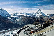
The Gornergrat (English: Gorner Ridge; 3,135 m (10,285 ft)) is a rocky ridge of the Pennine Alps, overlooking the Gorner Glacier south-east of Zermatt in Switzerland. It can be reached from Zermatt by the Gornergrat rack railway (GGB), the highest open-air railway in Europe. Between the Gornergrat railway station (3,090 m (10,140 ft)) and the summit is the Kulm Hotel (3,120 m (10,240 ft)) hosting the new Project "Stellarium Gornergrat" and until 2010 the Kölner Observatorium für SubMillimeter Astronomie KOSMA and before that (until 2005) the Gornergrat Infrared Telescope.
Contents
1 Overview
2 Gallery
3 See also
4 References
5 External links
Overview
It is located about three kilometers east of Zermatt in the Swiss canton of Valais. The Gornergrat is located between the Gornergletscher and Findelgletscher and offers a view of more than 20 four-thousand metre peaks, whose highest are Dufourspitze (Monte Rosa massif), Liskamm, Matterhorn, Dom and Weisshorn.
This is the last stop of the Gornergrat train, opened in 1898, which climbs almost 1,500 m (4,900 ft) through Riffelalp and Riffelberg. At the terminus on the south-western tip of the ridge is a hotel. The station forms part of the Zermatt ski area. From 1958 to 2007[2][3] there was a cable car from Gornergrat over the Hohtälli (3,275 m (10,745 ft)) to the Stockhorn (3,405 m (11,171 ft)) which, until the construction of the Klein Matterhorn cable car, was the highest mountain station in Zermatt.
At the west side of the Gorner Ridge, nearby the Rotenboden railway station is the peak Riffelhorn (2,928 m (9,606 ft)).
Gallery
Matterhorn (far before), viewed from Gornergrat railway station and, from left to right, Klein Matterhorn, Breithorn, the nowadays disconnected Lower Theodul Glacier, Upper Theodul Glacier (June 2006).

Gornergrat railway station.

From Schwarzsee (2,552 m) looking eastwards : first the Riffelhorn, then Gornergrat (with buildings), and the Hohtälli on the very left.

A view of Gorner Glacier in front, the Monte Rosa massif in the middle, and the major tributary of the Gorner Glacier, the Border Glacier (German: Grenzgletscher) to its right and the impressive Liskamm on the Swiss-Italian border, as viewed from Gornergrat (September 2007).


See also
- Gornergratbahn
- Riffelalptram
- List of mountains of Switzerland accessible by public transport
References
^ Retrieved from the Swisstopo topographic maps and Google Earth. The key col is located east of the summit at 3,085 metres.
^ Stockhorn lifts on Seilbahn Nostalgie (in German)
^ End of Gornergrat tram service - Funimag.com
External links
![]() Media related to Gornergrat at Wikimedia Commons
Media related to Gornergrat at Wikimedia Commons
This Valais location article is a stub. You can help Wikipedia by expanding it. |


Comments
Post a Comment