 Mixing
Barley, Lancashire
| Barley | |
|---|---|
 Barley Village Hall | |
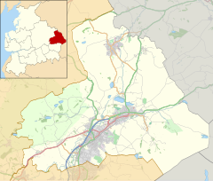 Barley Location in Pendle Borough Show map of the Borough of Pendle 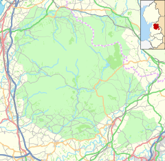 Barley Location in the Forest of Bowland AONB Show map of the Forest of Bowland  Barley Barley shown within Lancashire Show map of Lancashire | |
| OS grid reference | SD821405 |
| Civil parish |
|
| District |
|
| Shire county |
|
| Region |
|
| Country | England |
| Sovereign state | United Kingdom |
| Post town | BURNLEY |
| Postcode district | BB12 |
| Dialling code | 01282 |
| Police | Lancashire |
| Fire | Lancashire |
| Ambulance | North West |
| EU Parliament | North West England |
| UK Parliament |
|
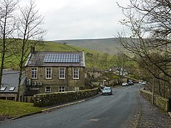
Barley is a village in the borough of Pendle, in Lancashire, England. It is in the civil parish of Barley-with-Wheatley Booth. The village lies between Black Moss Reservoirs and Ogden Reservoirs,[1] and is inside of the Forest of Bowland Area of Outstanding Natural Beauty (AONB).[2]
The village is situated close to Pendle Hill, and is a popular starting point for walkers of this hill.[3] The circular Pendle Way long-distance trail passes through here.
There is a children's playground by the stream. There is also a substantial 1920s built public house, The Pendle Inn, and a restaurant, The Barley Mow.
It has won the small village category in 1996 and the hamlet category of the Lancashire Best Kept Village competition in 2008 and 09.[4][5]
General history

The Pendle Inn in Barley
After a cow farm was established around 1266, Barley earned its livelihood from agriculture. This continued up until the 18th century. During the 18th century textiles began to be manufactured as an extra source of income. The brooks around Barley offered an effective source of waterpower which led to the building of several cotton factories. Two small cotton mills were built at Narrowgates and Barley Green. At its height, Barley Green Mill had 200 looms, until floods destroyed the building in 1880. The cotton twist mill at Narrowgates, which was built by William Hartley to spin cotton warp thread, and the adjacent weavers cottages survive and are now private houses.[1]
In December, United Utilities engineers were "stunned" to unearth a 17th-century cottage, complete with a cat skeleton, during a construction project in the village, near Lower Black Moss reservoir. There has been some speculation that the well-preserved cottage could have belonged to one of the Pendle witches, although there is no evidence to suggest that it did.
Simon Entwistle, an expert on the witches, said: "In terms of significance, it's like discovering Tutankhamen's tomb". Frank Giecco, from NP Archaeology, who unearthed the building, said: "It's like discovering your own little Pompeii. We rarely get the opportunity to work with something so well preserved." Many artefacts from the building's latter years, such as Victorian crockery, a tin bath and a bedstead, were discovered around the site.[6]
References
^ ab United Utilities. "Black Moss Reservoirs" (PDF). Retrieved 4 August 2010..mw-parser-output cite.citation{font-style:inherit}.mw-parser-output .citation q{quotes:"""""""'""'"}.mw-parser-output .citation .cs1-lock-free a{background:url("//upload.wikimedia.org/wikipedia/commons/thumb/6/65/Lock-green.svg/9px-Lock-green.svg.png")no-repeat;background-position:right .1em center}.mw-parser-output .citation .cs1-lock-limited a,.mw-parser-output .citation .cs1-lock-registration a{background:url("//upload.wikimedia.org/wikipedia/commons/thumb/d/d6/Lock-gray-alt-2.svg/9px-Lock-gray-alt-2.svg.png")no-repeat;background-position:right .1em center}.mw-parser-output .citation .cs1-lock-subscription a{background:url("//upload.wikimedia.org/wikipedia/commons/thumb/a/aa/Lock-red-alt-2.svg/9px-Lock-red-alt-2.svg.png")no-repeat;background-position:right .1em center}.mw-parser-output .cs1-subscription,.mw-parser-output .cs1-registration{color:#555}.mw-parser-output .cs1-subscription span,.mw-parser-output .cs1-registration span{border-bottom:1px dotted;cursor:help}.mw-parser-output .cs1-ws-icon a{background:url("//upload.wikimedia.org/wikipedia/commons/thumb/4/4c/Wikisource-logo.svg/12px-Wikisource-logo.svg.png")no-repeat;background-position:right .1em center}.mw-parser-output code.cs1-code{color:inherit;background:inherit;border:inherit;padding:inherit}.mw-parser-output .cs1-hidden-error{display:none;font-size:100%}.mw-parser-output .cs1-visible-error{font-size:100%}.mw-parser-output .cs1-maint{display:none;color:#33aa33;margin-left:0.3em}.mw-parser-output .cs1-subscription,.mw-parser-output .cs1-registration,.mw-parser-output .cs1-format{font-size:95%}.mw-parser-output .cs1-kern-left,.mw-parser-output .cs1-kern-wl-left{padding-left:0.2em}.mw-parser-output .cs1-kern-right,.mw-parser-output .cs1-kern-wl-right{padding-right:0.2em}
^ Forest of Bowland map (Map). forestofbowland.com. Lancashire County Council.
^ Walks in Yorkshire. "Circular from Barley via Pendle Hill and Ogden Clough Reservoirs". Retrieved 4 August 2010.
^ "Barley is cream of crop". Lancashire Telegraph. Newsquest Media Group. 12 September 1996. Retrieved 5 September 2015.
^ "Roughlee and Barley honoured in Lancs Best-Kept Village contest". Pendle Today. Johnston Press. 13 October 2009. Retrieved 5 September 2015.
^ "'Witch's cottage' unearthed near Pendle Hill, Lancashire"; bbc.co.uk
External links
| Wikimedia Commons has media related to Barley, Lancashire. |
- forestofbowland.com - Aitken Wood and Pendle Sculpture Trail Walk
This Lancashire location article is a stub. You can help Wikipedia by expanding it. |


Comments
Post a Comment