 Mixing
Kosciusko County, Indiana
Kosciusko County, Indiana | |
|---|---|
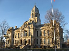 Kosciusko County Courthouse in Warsaw, Indiana | |
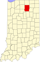 Location in the U.S. state of Indiana | |
 Indiana's location in the U.S. | |
| Founded | 1836 |
| Named for | Tadeusz Kościuszko |
| Seat | Warsaw |
| Largest city | Warsaw |
| Area | |
| • Total | 554.39 sq mi (1,436 km2) |
| • Land | 531.38 sq mi (1,376 km2) |
| • Water | 23.01 sq mi (60 km2), 4.15% |
| Population | |
| • (2010) | 77,358 |
| • Density | 144/sq mi (55.57/km2) |
| Congressional districts | 2nd, 3rd |
| Time zone | Eastern: UTC−5/−4 |
| Website | www.kcgov.com |
Footnotes: Indiana county number 43 | |
Kosciusko County (/ˌkɒskiˈʌskoʊ/ KOS-kee-US-koh) is a county located in the U.S. state of Indiana. Census 2010 recorded the population at 77,358.[1] The county seat is Warsaw.[2]
The county was formed in 1836. It was named after the Polish general Tadeusz Kościuszko who served in the American Revolutionary War and then returned to Poland.[3] The county seat is named after Warsaw, the capital of Poland.[4]
Contents
1 Geographical features
1.1 Adjacent counties
1.2 Major highways
1.3 Airport
2 Newspapers
3 Community
3.1 Cities
3.2 Towns
3.3 Unincorporated communities
4 Townships
5 Climate and weather
6 Government
7 Education
7.1 School districts
8 Demographics
9 Notable residents
10 See also
11 References
12 External links
13 Sources
Geographical features
According to the 2010 census, the county has a total area of 554.39 square miles (1,435.9 km2), of which 531.38 square miles (1,376.3 km2) (or 95.85%) is land and 23.01 square miles (59.6 km2) (or 4.15%) is water.[5]
Adjacent counties
Elkhart County (north)
Noble County (northeast)
Whitley County (southeast)
Wabash County (south)
Fulton County (southwest)
Marshall County (west)
Major highways
 U.S. Route 30
 Indiana State Road 10
 Indiana State Road 13
 Indiana State Road 14
 Indiana State Road 15
 Indiana State Road 19
 Indiana State Road 25
Airport
- KASW - Warsaw Municipal Airport
- KC03 - Nappannee Municipal Airport
Newspapers
Times-Union
The Mail-Journal
The PAPER
Ink Free News
Community

Southern Kosciusko County is dotted with small lakes like Beaver Dam Lake (foreground) near Silver Lake.
Cities
- Nappanee
- Warsaw
Towns
- Burket
- Claypool
- Etna Green
- Leesburg
- Mentone
- Milford
- North Webster
- Pierceton
- Sidney
- Silver Lake
- Syracuse
- Winona Lake
Unincorporated communities
- Arrowhead Park
- Atwood
- Barbee
- Bayfield
- Beaver Dam
- Bell Rohr Park
- Black Point
- Buttermilk Point
- Cedar Point
- Clunette
- DeFries Landing
- Eagle Point
- Enchanted Hills
- Epworth Forest
- Forest Glen
- Gravelton
- Hastings
- Highbanks
- Highlands Park
- Island Park
- Kalorama Park
- Kanata Manayunk
- Kinsey
- Lakeside Park
- Lakeview Spring
- Lowman Corner
- Marineland Gardens
- Milford Junction
- Mineral Springs
- Monoquet
- Musquabuck Park
- Oakwood Park
- Osborn Landing
- Oswego
- Packerton
- Palestine
- Pickwick Park
- Potawatomi Park
- Quaker Haven Park
- Redmon Park
- Sevastopol
- Shady Banks
- Silver Point
- South Park
- Stoneburner Landing
- Stony Ridge
- Sunrise Beach
- Vawter Park
- Walker Park
- Wawasee
- Wawasee Village
- Wa-Will-Away Park
- Wooster
- Yellowbanks
Townships
- Clay
- Etna
- Franklin
- Harrison
- Jackson
- Jefferson
- Lake
- Monroe
- Plain
- Prairie
- Scott
- Seward
- Tippecanoe
- Turkey Creek
- Van Buren
- Washington
- Wayne
Climate and weather
Warsaw, Indiana | ||||||||||||||||||||||||||||||||||||||||||||||||||||||||||||
|---|---|---|---|---|---|---|---|---|---|---|---|---|---|---|---|---|---|---|---|---|---|---|---|---|---|---|---|---|---|---|---|---|---|---|---|---|---|---|---|---|---|---|---|---|---|---|---|---|---|---|---|---|---|---|---|---|---|---|---|---|
| Climate chart (explanation) | ||||||||||||||||||||||||||||||||||||||||||||||||||||||||||||
| ||||||||||||||||||||||||||||||||||||||||||||||||||||||||||||
| ||||||||||||||||||||||||||||||||||||||||||||||||||||||||||||
In recent years, average temperatures in Warsaw have ranged from a low of 15 °F (−9 °C) in January to a high of 82 °F (28 °C) in July, although a record low of −25 °F (−32 °C) was recorded in January 1985 and a record high of 103 °F (39 °C) was recorded in July 1976. Average monthly precipitation ranged from 1.45 inches (37 mm) in February to 4.51 inches (115 mm) in June.[6]
Government
The county government is a constitutional body, and is granted specific powers by the Constitution of Indiana, and by the Indiana Code.
County Council: The county council is the legislative branch of the county government and controls all the spending and revenue collection in the county. Representatives are elected from county districts. The council members serve four-year terms. They are responsible for setting salaries, the annual budget, and special spending. The council also has limited authority to impose local taxes, in the form of an income and property tax that is subject to state level approval, excise taxes, and service taxes.[7][8]
Board of Commissioners: The executive body of the county is made of a board of commissioners. The commissioners are elected county-wide, in staggered terms, and each serves a four-year term. One of the commissioners, typically the most senior, serves as president. The commissioners are charged with executing the acts legislated by the council, collecting revenue, and managing the day-to-day functions of the county government.[7][8]
Court: The county maintains a small claims court that can handle some civil cases. The county also maintains a Circuit and Superior Court. The judge on each court is elected to a term of six years and must be a member of the Indiana bar.
County Officials: The county has several other elected offices, including sheriff, coroner, auditor, treasurer, recorder, surveyor, and circuit court clerk Each of these elected officers serves a term of four years and oversees a different part of county government. Members elected to county government positions are required to declare party affiliations and to be residents of the county.[8]
Kosciusko County is part of Indiana's 3rd congressional district and in 2008 was represented by Mark Souder in the United States Congress.[9] It is also part of Indiana Senate districts 9, 13, 17 and 18[10] and Indiana House of Representatives districts 18, 22 and 23.[11]
Elected officials:
- William Goshert - Sheriff
- Daniel Hampton - Prosecutor
- Susan Engelberth - Assessor
- Michelle Puckett - Auditor
- Ann Torpy - Clerk
- Joetta Mitchell - County Recorder
- Sue Ann Mitchell - Treasurer
- Ronald Truex - Middle District Commissioner
- Robert M. Conley - Southern District Commissioner
- Bradford Jackson, President - Northern District Commissioner
- Michael Wilson, Certified Death Investigator, Coroner
| Year |
Republican |
Democratic |
Third parties |
|---|---|---|---|
2016 |
73.8% 23,935 |
19.5% 6,313 |
6.8% 2,193 |
2012 |
74.8% 22,558 |
22.8% 6,862 |
2.4% 720 |
2008 |
67.9% 20,488 |
30.6% 9,236 |
1.5% 461 |
2004 |
78.1% 22,136 |
21.1% 5,977 |
0.9% 247 |
2000 |
75.3% 19,040 |
22.9% 5,785 |
1.8% 459 |
1996 |
63.0% 15,084 |
25.8% 6,166 |
11.3% 2,695 |
1992 |
57.4% 14,179 |
21.5% 5,307 |
21.1% 5,197 |
1988 |
76.7% 17,761 |
23.0% 5,321 |
0.4% 81 |
1984 |
77.9% 17,560 |
21.6% 4,877 |
0.5% 110 |
1980 |
68.8% 15,633 |
25.0% 5,684 |
6.2% 1,413 |
1976 |
65.6% 14,505 |
33.1% 7,328 |
1.3% 291 |
1972 |
78.9% 16,216 |
20.6% 4,233 |
0.5% 96 |
1968 |
64.0% 12,633 |
27.1% 5,342 |
9.0% 1,769 |
1964 |
54.1% 10,488 |
45.2% 8,759 |
0.7% 141 |
1960 |
69.1% 13,539 |
29.8% 5,839 |
1.1% 213 |
1956 |
71.7% 12,777 |
27.5% 4,904 |
0.8% 143 |
1952 |
69.0% 11,521 |
28.0% 4,677 |
3.1% 512 |
1948 |
62.8% 9,327 |
34.4% 5,102 |
2.9% 426 |
1944 |
65.1% 9,577 |
33.1% 4,865 |
1.8% 266 |
1940 |
62.7% 9,879 |
36.6% 5,768 |
0.7% 113 |
1936 |
53.9% 8,182 |
45.4% 6,890 |
0.7% 107 |
1932 |
47.8% 7,063 |
50.5% 7,475 |
1.7% 253 |
1928 |
63.2% 7,973 |
36.0% 4,537 |
0.9% 110 |
1924 |
58.3% 6,819 |
37.5% 4,384 |
4.2% 487 |
1920 |
61.7% 8,326 |
35.8% 4,836 |
2.5% 342 |
1916 |
51.2% 4,025 |
43.8% 3,447 |
5.0% 393 |
1912 |
24.5% 1,767 |
39.0% 2,817 |
36.5% 2,636 |
1908 |
54.5% 4,377 |
41.8% 3,362 |
3.7% 300 |
1904 |
57.9% 4,550 |
37.1% 2,913 |
5.1% 398 |
1900 |
56.3% 4,422 |
41.5% 3,265 |
2.2% 172 |
1896 |
55.6% 4,342 |
43.2% 3,372 |
1.2% 94 |
1892 |
53.2% 3,823 |
42.7% 3,064 |
4.1% 294 |
1888 |
55.8% 4,147 |
41.5% 3,081 |
2.7% 203 |
Education
School districts
- Tippecanoe Valley School Corporation
- Triton School Corporation
- Warsaw Community Schools
- Wawasee Community School Corporation
- Whitko Community School Corporation
- Wa-Nee Community Schools
Demographics
| Historical population | |||
|---|---|---|---|
| Census | Pop. | %± |
|
| 1840 | 4,170 | — | |
| 1850 | 10,243 | 145.6% | |
| 1860 | 17,418 | 70.0% | |
| 1870 | 23,531 | 35.1% | |
| 1880 | 26,494 | 12.6% | |
| 1890 | 28,645 | 8.1% | |
| 1900 | 29,109 | 1.6% | |
| 1910 | 27,936 | −4.0% | |
| 1920 | 27,120 | −2.9% | |
| 1930 | 27,488 | 1.4% | |
| 1940 | 29,561 | 7.5% | |
| 1950 | 33,002 | 11.6% | |
| 1960 | 40,373 | 22.3% | |
| 1970 | 48,127 | 19.2% | |
| 1980 | 59,555 | 23.7% | |
| 1990 | 65,294 | 9.6% | |
| 2000 | 74,057 | 13.4% | |
| 2010 | 77,358 | 4.5% | |
| Est. 2017 | 79,206 | [13] | 2.4% |
| U.S. Decennial Census[14] 1790-1960[15] 1900-1990[16] 1990-2000[17] 2010-2013[1] | |||
As of the 2010 United States Census, there were 77,358 people, 29,197 households, and 20,740 families residing in the county.[18] The population density was 145.6 inhabitants per square mile (56.2/km2). There were 37,038 housing units at an average density of 69.7 per square mile (26.9/km2).[5] The racial makeup of the county was 93.3% white, 0.8% Asian, 0.7% black or African American, 0.3% Native American, 3.4% from other races, and 1.4% from two or more races. Those of Hispanic or Latino origin made up 7.3% of the population.[18] In terms of ancestry, 33.5% were German, 11.5% were Irish, 10.8% were English, and 8.2% were American.[19]
Of the 29,197 households, 33.9% had children under the age of 18 living with them, 56.6% were married couples living together, 9.5% had a female householder with no husband present, 29.0% were non-families, and 23.9% of all households were made up of individuals. The average household size was 2.60 and the average family size was 3.07. The median age was 37.7 years.[18]
The median income for a household in the county was $47,697 and the median income for a family was $56,305. Males had a median income of $44,358 versus $29,320 for females. The per capita income for the county was $24,019. About 7.0% of families and 10.0% of the population were below the poverty line, including 13.5% of those under age 18 and 5.2% of those age 65 or over.[20]
Notable residents
Chris Schenkel, former Sportscaster for ABC Sports. Resided in Leesburg, Indiana.[21]
See also
- National Register of Historic Places listings in Kosciusko County, Indiana
References
^ ab "Kosciusko County QuickFacts". United States Census Bureau. Archived from the original on 2011-07-13. Retrieved 2011-09-25..mw-parser-output cite.citation{font-style:inherit}.mw-parser-output q{quotes:"""""""'""'"}.mw-parser-output code.cs1-code{color:inherit;background:inherit;border:inherit;padding:inherit}.mw-parser-output .cs1-lock-free a{background:url("//upload.wikimedia.org/wikipedia/commons/thumb/6/65/Lock-green.svg/9px-Lock-green.svg.png")no-repeat;background-position:right .1em center}.mw-parser-output .cs1-lock-limited a,.mw-parser-output .cs1-lock-registration a{background:url("//upload.wikimedia.org/wikipedia/commons/thumb/d/d6/Lock-gray-alt-2.svg/9px-Lock-gray-alt-2.svg.png")no-repeat;background-position:right .1em center}.mw-parser-output .cs1-lock-subscription a{background:url("//upload.wikimedia.org/wikipedia/commons/thumb/a/aa/Lock-red-alt-2.svg/9px-Lock-red-alt-2.svg.png")no-repeat;background-position:right .1em center}.mw-parser-output .cs1-subscription,.mw-parser-output .cs1-registration{color:#555}.mw-parser-output .cs1-subscription span,.mw-parser-output .cs1-registration span{border-bottom:1px dotted;cursor:help}.mw-parser-output .cs1-hidden-error{display:none;font-size:100%}.mw-parser-output .cs1-visible-error{font-size:100%}.mw-parser-output .cs1-subscription,.mw-parser-output .cs1-registration,.mw-parser-output .cs1-format{font-size:95%}.mw-parser-output .cs1-kern-left,.mw-parser-output .cs1-kern-wl-left{padding-left:0.2em}.mw-parser-output .cs1-kern-right,.mw-parser-output .cs1-kern-wl-right{padding-right:0.2em}
^ "Find a County". National Association of Counties. Archived from the original on 2011-05-31. Retrieved 2011-06-07.
^ Gannett, Henry (1905). The Origin of Certain Place Names in the United States. Government Printing Office. p. 177.
^ De Witt Clinton Goodrich & Charles Richard Tuttle (1875). An Illustrated History of the State of Indiana. Indiana: R. S. Peale & co. p. 563.
^ ab "Population, Housing Units, Area, and Density: 2010 - County". United States Census Bureau. Retrieved 2015-07-10.
^ ab "Monthly Averages for Warsaw, Indiana". The Weather Channel. Retrieved 2011-01-27.
^ ab Indiana Code. "Title 36, Article 2, Section 3". IN.gov. Retrieved 2008-09-16.
^ abc Indiana Code. "Title 2, Article 10, Section 2" (PDF). IN.gov. Retrieved 2008-09-16.
^ "US Congressman Mark Souder". US Congress. Archived from the original on 2008-10-09. Retrieved 2008-10-08.
^ "Indiana Senate Districts". State of Indiana. Retrieved 2011-07-14.
^ "Indiana House Districts". State of Indiana. Retrieved 2011-07-14.
^ Leip, David. "Dave Leip's Atlas of U.S. Presidential Elections". uselectionatlas.org. Retrieved 2018-05-17.
^ "Population and Housing Unit Estimates". Retrieved June 9, 2017.
^ "U.S. Decennial Census". United States Census Bureau. Archived from the original on May 12, 2015. Retrieved July 10, 2014.
^ "Historical Census Browser". University of Virginia Library. Retrieved July 10, 2014.
^ "Population of Counties by Decennial Census: 1900 to 1990". United States Census Bureau. Retrieved July 10, 2014.
^ "Census 2000 PHC-T-4. Ranking Tables for Counties: 1990 and 2000" (PDF). United States Census Bureau. Retrieved July 10, 2014.
^ abc "DP-1 Profile of General Population and Housing Characteristics: 2010 Demographic Profile Data". United States Census Bureau. Retrieved 2015-07-10.
^ "DP02 SELECTED SOCIAL CHARACTERISTICS IN THE UNITED STATES – 2006-2010 American Community Survey 5-Year Estimates". United States Census Bureau. Retrieved 2015-07-10.
^ "DP03 SELECTED ECONOMIC CHARACTERISTICS – 2006-2010 American Community Survey 5-Year Estimates". United States Census Bureau. Retrieved 2015-07-10.
^ http://yesteryear.clunette.com/schenkel.html
External links
- Kosciusko County
- Kosciusko County Chamber of Commerce
- Kosciusko County Convention and Visitors Bureau
Sources
Places adjacent to Kosciusko County, Indiana | ||||||||||
|---|---|---|---|---|---|---|---|---|---|---|
| ||||||||||
Municipalities and communities of Kosciusko County, Indiana, United States | ||
|---|---|---|
County seat: Warsaw | ||
| Cities |
|
|
| Towns |
|
|
| Townships |
|
|
| Unincorporated communities |
|
|
| Footnotes | ‡This populated place also has portions in an adjacent county or counties |
|
Indianapolis (capital) | ||
| Topics |
|
 Seal of Indiana |
| Society |
|
|
| Regions |
|
|
| Largest cities |
|
|
| Largest towns |
|
|
| Counties |
|
|
Coordinates: 41°14′N 85°52′W / 41.24°N 85.86°W / 41.24; -85.86


Comments
Post a Comment