 Mixing
Sarangani, Davao Occidental
Sarangani | |
|---|---|
Municipality | |
| Municipality of Sarangani | |
Nickname(s):
| |
| Motto(s): Sarangani Bayan Natin, Sarangani Paraiso Natin! | |
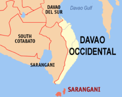 Map of Davao Occidental with Sarangani highlighted | |
 Sarangani Location within the Philippines | |
| Coordinates: 5°24′N 125°28′E / 5.4°N 125.47°E / 5.4; 125.47Coordinates: 5°24′N 125°28′E / 5.4°N 125.47°E / 5.4; 125.47 | |
| Country | |
| Region | Davao Region (Region XI) |
| Province | Davao Occidental |
| District | Lone District |
| Founded | 1980 |
| Barangays | 12 (see Barangays) |
| Government [1] | |
| • Type | Sangguniang Bayan |
| • Mayor |
Jerry T. Cawa |
| • Electorate | 13,318 voters (2016) |
| Area [2] | |
| • Total | 97.72 km2 (37.73 sq mi) |
| Population (2015 census)[3] | |
| • Total | 24,039 |
| • Density | 250/km2 (640/sq mi) |
| Time zone | UTC+8 (PST) |
| ZIP code | 8015 |
| PSGC | 118605000 |
| IDD : area code | +63 (0)82 |
| Climate type | Tropical rainforest climate |
| Income class | 4th municipal income class |
| Revenue (₱) | 70,082,321.62 (2016) |
| Native languages | Davawenyo Cebuano Sarangani language Sangirese Tagalog |
| Website | www.saranganidavsur.gov.ph |
Sarangani, officially the Municipality of Sarangani, is a 4th class municipality in the province of Davao Occidental, Philippines. According to the 2015 census, it has a population of 24,039 people.[3]
The municipality consists of 2 major islands (the eponymous Sarangani Island and Balut Island) and 1 minor islet (Olanivan Island), collectively called as the Sarangani Islands, located just south of Mindanao island in the Celebes Sea. It is the municipality of the Philippines bordering Indonesia.
Contents
1 Barangays
2 Demographics
3 Local government
4 References
5 External links
Barangays
Sarangani is politically subdivided into 12 barangays.
Balut Island
- Batuganding
- Konel
- Lipol
- Mabila (Poblacion)
- Tinina
- Gomtago
- Tagen
- Tucal
Sarangani Island
- Patuco (Sarangani Norte) (includes Olanivan islet)
- Laker (Sarangani Sur)
- Camahual
- Camalig
Demographics

Map of the Sarangani islands
| Population census of Sarangani | ||
|---|---|---|
| Year | Pop. | ±% p.a. |
| 1980 | 11,960 | — |
| 1990 | 15,003 | +2.29% |
| 1995 | 16,648 | +1.97% |
| 2000 | 18,391 | +2.16% |
| 2007 | 20,394 | +1.44% |
| 2010 | 23,290 | +4.95% |
| 2015 | 24,039 | +0.60% |
| Source: Philippine Statistics Authority[3][4][5][6] | ||
Local government
Municipal officials 2013-2016:
- Mayor: Virginia Cawa
- Vice Mayor: Jerry Cawa
- Councilors:
- Alfredo Lora
- Sergio Tablingon
- Adelan de Arce
- Jamere Ismael
- Lorencio Angin
- Windy Grace Gomez
- Jovanie Amierol
- Arturo Olarte, Jr.
References
^ "Municipality". Quezon City, Philippines: Department of the Interior and Local Government. Retrieved 31 May 2013..mw-parser-output cite.citation{font-style:inherit}.mw-parser-output q{quotes:"""""""'""'"}.mw-parser-output code.cs1-code{color:inherit;background:inherit;border:inherit;padding:inherit}.mw-parser-output .cs1-lock-free a{background:url("//upload.wikimedia.org/wikipedia/commons/thumb/6/65/Lock-green.svg/9px-Lock-green.svg.png")no-repeat;background-position:right .1em center}.mw-parser-output .cs1-lock-limited a,.mw-parser-output .cs1-lock-registration a{background:url("//upload.wikimedia.org/wikipedia/commons/thumb/d/d6/Lock-gray-alt-2.svg/9px-Lock-gray-alt-2.svg.png")no-repeat;background-position:right .1em center}.mw-parser-output .cs1-lock-subscription a{background:url("//upload.wikimedia.org/wikipedia/commons/thumb/a/aa/Lock-red-alt-2.svg/9px-Lock-red-alt-2.svg.png")no-repeat;background-position:right .1em center}.mw-parser-output .cs1-subscription,.mw-parser-output .cs1-registration{color:#555}.mw-parser-output .cs1-subscription span,.mw-parser-output .cs1-registration span{border-bottom:1px dotted;cursor:help}.mw-parser-output .cs1-hidden-error{display:none;font-size:100%}.mw-parser-output .cs1-visible-error{font-size:100%}.mw-parser-output .cs1-subscription,.mw-parser-output .cs1-registration,.mw-parser-output .cs1-format{font-size:95%}.mw-parser-output .cs1-kern-left,.mw-parser-output .cs1-kern-wl-left{padding-left:0.2em}.mw-parser-output .cs1-kern-right,.mw-parser-output .cs1-kern-wl-right{padding-right:0.2em}
^
"Province: Davao Occidental". PSGC Interactive. Quezon City, Philippines: Philippine Statistics Authority. Retrieved 12 November 2016.
^ abc
Census of Population (2015). "Region XI (Davao Region)". Total Population by Province, City, Municipality and Barangay. PSA. Retrieved 20 June 2016.
^
Census of Population and Housing (2010). "Region XI (Davao Region)". Total Population by Province, City, Municipality and Barangay. NSO. Retrieved 29 June 2016.
^
Censuses of Population (1903–2007). "Region XI (Davao Region)". Table 1. Population Enumerated in Various Censuses by Province/Highly Urbanized City: 1903 to 2007. NSO.
^
"Province of Davao del Sur". Municipality Population Data. Local Water Utilities Administration Research Division. Retrieved 17 December 2016.
External links
- Philippine Standard Geographic Code
- Philippine Census Information
- Local Governance Performance Management System
Places adjacent to Sarangani, Davao Occidental | ||||||||||
|---|---|---|---|---|---|---|---|---|---|---|
| ||||||||||
Malita (capital) | |
| Municipalities |
|
This article about a location in Davao Region is a stub. You can help Wikipedia by expanding it. |


Comments
Post a Comment