 Mixing
Banatić
Banatić Банатић | |
|---|---|
Urban neighborhood | |
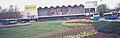
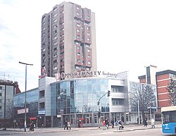 Banatić, Jaša Tomić Boulevard | |
| Country | |
| Province | Vojvodina |
| District | South Bačka |
| Municipality | Novi Sad |
| Time zone | UTC+1 (CET) |
| • Summer (DST) | UTC+2 (CEST) |
| Area code | +381(0)21 |
| Car plates | NS |
Banatić (Serbian: Банатић) is an urban neighborhood of the city of Novi Sad, Serbia. Its name means "a little Banat".
Contents
1 Borders
2 Neighbouring city quarters
3 Features
4 Gallery
5 See also
6 References
7 External links
Borders
The southern border of Banatić is Bulevar kralja Petra I (King Petar I Boulevard), the eastern border is Bulevar oslobođenja (Liberation Boulevard), the north-eastern borders are Bulevar Jaše Tomića (Jaša Tomić Boulevard) and Kisačka ulica (Kisač street), the northern border is railway Belgrade-Subotica, the north-western border is ulica Kornelija Stankovića (Kornelije Stanković Street), and the western border is Rumenačka ulica (Rumenka Street).
Neighbouring city quarters

Map of the urban area of Novi Sad with city quarters, showing the location of Banatić

Banatić, Liberation Boulevard
The neighbouring city quarters are: Detelinara in the west, Sajmište in the south, Rotkvarija and Salajka in the east, and Pervazovo Naselje and Industrijska Zona Jug in the north.
Features
The city main train and bus stations are located in Banatić.
Gallery
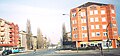
Banatić, Jaša Tomić Boulevard
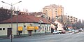
Banatić, King Petar I Boulevard
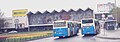
Banatić, Train station
Banatić, Train station


See also
- Neighborhoods of Novi Sad
References
- Jovan Mirosavljević, Brevijar ulica Novog Sada 1745-2001, Novi Sad, 2002.
- Milorad Grujić, Vodič kroz Novi Sad i okolinu, Novi Sad, 2004.
External links
| Wikimedia Commons has media related to Banatić. |
- Detailed map of Novi Sad and Banatić
- Map
Neighborhoods and suburbs of Novi Sad Municipalities of Novi Sad and Petrovaradin | ||
|---|---|---|
| Neighborhoods in “Novi Sad Proper” |
|
 |
| Neighborhoods in Petrovaradin |
|
|
| Neighborhoods in Sremska Kamenica |
|
|
| Suburbs |
|
|


Comments
Post a Comment