 Mixing
Tysfjord
Tysfjord kommune Divtasvuona suohkan | |||
|---|---|---|---|
Municipality | |||
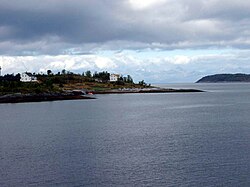 View of the Skarberget area in Tysfjord | |||
| |||
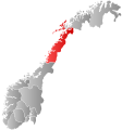
 Tysfjord within Nordland | |||
| Coordinates: 68°03′51″N 16°28′50″E / 68.06417°N 16.48056°E / 68.06417; 16.48056Coordinates: 68°03′51″N 16°28′50″E / 68.06417°N 16.48056°E / 68.06417; 16.48056 | |||
| Country | Norway | ||
| County | Nordland | ||
| District | Ofoten | ||
| Established | 1869 | ||
| Administrative centre | Kjøpsvik | ||
| Government | |||
| • Mayor (2011) |
Tor Asgeir Johansen (Ap) | ||
| Area | |||
| • Total | 1,463.72 km2 (565.15 sq mi) | ||
| • Land | 1,358.47 km2 (524.51 sq mi) | ||
| • Water | 105.25 km2 (40.64 sq mi) | ||
| Area rank | #56 in Norway | ||
| Population (2017) | |||
| • Total | 1,960 | ||
| • Rank | #330 in Norway | ||
| • Density | 1.4/km2 (4/sq mi) | ||
| • Change (10 years) |
-4.5% | ||
| Demonym(s) | Tysfjerding[1] |
||
| Time zone | UTC+01:00 (CET) |
||
| • Summer (DST) | UTC+02:00 (CEST) |
||
| ISO 3166 code | NO-1850 | ||
| Official language form | Neutral and Lule Sami |
||
| Website | tysfjord.kommune.no | ||
Data from Statistics Norway | |||

Tysfjord (Norwegian) or Divtasvuodna (Lule Sami)[2] is a municipality in Nordland county, Norway. It is part of the traditional district of Ofoten. The administrative centre of the municipality is the village of Kjøpsvik. Other villages include Drag, Hundholmen, Korsnes, Musken, Rørvika, Skarberget, and Storå.
Tysfjord has a very large population of Lule Sami people. The Árran Lule Sami Center is located in the village of Drag. With the Norwegian language and Lule Sami language both as official languages of the municipality, Tysfjord is the only municipality in Norway where speakers of Lule Sami should theoretically be able to speak that language with officials, although this has not come completely to fruition.
The 1,464-square-kilometre (565 sq mi) municipality is the 56th largest by area out of the 422 municipalities in Norway. Tysfjord is the 330th most populous municipality in Norway with a population of 1,960. The municipality's population density is 1.4 inhabitants per square kilometre (3.6/sq mi) and its population has decreased by 4.5% over the last decade.[3]
Contents
1 General information
1.1 Name
1.2 Coat-of-arms
1.3 Churches
2 History
2.1 Ethnicity
3 Government
3.1 Municipal council
4 Economy
5 Geography
5.1 Nature
5.2 Climate
6 Transport
7 Villages
8 References
9 External links
General information

Stetind mountain and the fjord
The municipality of Tysfjord was established on 1 January 1869 when it was separated from the municipality of Lødingen. Initially, the population of Tysfjord was 1,402. On 1 January 1964, the Tysnes and Molvik village areas (population: 33) was transferred from Hamarøy to Tysfjord.[4]
In 2017, it was decided that Tysfjord would be divided along the fjord with the eastern half being merged with the neighboring municipalities of Narvik and Ballangen to form a new, larger municipality of Narvik effective 1 January 2020. The remaining western half will be merged with the municipality of Hamarøy on the same date.[5][6]
Name
The municipality is named after the Tysfjorden (the fjord that the municipality surrounds). Tysfjord is a Norwegianized form of the Lule Sami name Divtasvuodna (first recorded around 1520 as "Tyttisfiorden"). The meaning of the first element divtas is unknown. (A popular belief, and common interpretation, is that the first element should be the genitive case of the name of the Norse god Týr - but this does not fit either with the Sami form or the oldest spellings of the name.) The last element is vuodna which means "fjord" in the Sami language.[7]
Coat-of-arms
The coat-of-arms is from modern times; they were granted on 31 July 1987. The arms show a black lobster on a silver background. The lobsters in Tysfjord are the most northerly in the world.[8]
Churches
The Church of Norway has three parishes (sokn) within the municipality of Tysfjord. It is part of the Ofoten prosti (deanery) in the Diocese of Sør-Hålogaland.
| Parish (Sokn) |
Church Name | Location of the Church |
Year Built |
|---|---|---|---|
| Drag/Helland | Drag/Helland Church | Drag | 1972 |
| Kjøpsvik | Kjøpsvik Church | Kjøpsvik | 1975 |
| Korsnes | Korsnes Church | Korsnes | 1889 |
History
There are prehistoric rock carvings at Leiknes showing scenes of hunting, and the world's oldest known depiction of an orca whale.[citation needed]
In 1948, an investigation that had lasted for years, was dismissed in regards to "a large group of Sami from Tysfjord".[9]
These individuals had worked as guides—guiding Norwegians who chose to flee into Sweden.[9]
In November 2017, a Norwegian police report was published exposing sexual abuse in the municipality, following investigations in 2016. The police identified 151 cases of sexual abuse from the 1950s to 2017. Around two-thirds of the victims and alleged abusers were Sami.[10] The community is described as being 'in recovery' but prosecution of the older cases has not been possible under Norwegian statute of limitations law. 40 cases dealt with sexual intercourse with underage children.[11]
Ethnicity
A 2004 article in Avisa Nordland estimated that out of 2,209 inhabitants, between 600 and 1000 are Sami.[12]
Government
All municipalities in Norway, including Tysfjord, are responsible for primary education (through 10th grade), outpatient health services, senior citizen services, unemployment and other social services, zoning, economic development, and municipal roads. The municipality is governed by a municipal council of elected representatives, which in turn elect a mayor.
Municipal council
The municipal council (Kommunestyre) of Tysfjord is made up of 17 representatives that are elected every four years. Currently, the party breakdown is as follows:[13]
| Party Name | Name in Norwegian | Number of representatives |
|
|---|---|---|---|
| Labour Party | Arbeiderpartiet | 5 | |
| Centre Party | Senterpartiet | 2 | |
| Socialist Left Party | Sosialistisk Venstreparti | 1 | |
| Local Lists | Lokale lister | 9 | |
| Total number of members: | 17 | ||
Economy
Due to the limestone in Tysfjord, a cement factory was established with production starting in 1920.[14] The modern Norcem factory still is a vital employer in Kjøpsvik, with about 130 employees; since 1999 it has been a part of the German worldwide company Heidelberger Cement. Public services, some tourism, and agriculture are the other main sources of income in Tysfjord.
Geography

Tysfjord municipality map
The municipality is located along the Tysfjorden. The Tysfjorden is the second deepest fjord in Norway, with a maximum depth of 897 metres (2,943 ft). The municipality borders Ballangen in the north, Hamarøy in the south, Sweden in the east, and the Vestfjorden in the northwest. The island of Hulløya lies in the middle of the Tysfjorden.
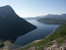
The municipality is dominated by grey granite mountains; pine, birch, and aspen woodlands and forests; and the many fjord branches. Tysfjord's most dominant mountain, Stetind, is famous in Norway. This 1,392-metre (4,567 ft) high natural granite obelisk, rising straight out of the fjord, is an awe-inspiring sight (Picture 1, Picture 2). In Norwegian, it is called gudenes ambolt which means the "anvil of the gods", partly because the summit forms a plateau. This was selected to be the national mountain of Norway in the autumn of 2002. The famous British climber William C. Slingsby described it as the ugliest mountain I ever saw; he did not reach the summit.
The mountains near the border with Sweden have peaks up to 1,500 metres (4,921 ft) above sea level, and with a large glacier, Gihtsejiegŋa. There are several nature reserves in Tysfjord. Mannfjordbotn reserve has undisturbed forests at the head of a narrow fjord branch surrounded by granite mountain walls.[15] From Hellemobotn, at the head of Hellemofjorden, the distance to the border with Sweden is only 6.3 kilometres (4 mi); this is also a scenic hiking terrain (Picture) with a canyon opening up in Hellemobotn (Picture). There are also caves, such as the very deep Raggejavreraige. Lakes in the region include Baugevatnet, Båvrojávrre, Kilvatnet, Langvatnet, and Skilvatnet. Silver birch occurs in Tysfjord, as one of few areas in North Norway (silver birch need more summer warmth than the more common downy birch).
Nature

Orca taking a look above the water
For many years since 1990, a large part of the stock of Norwegian herring has stayed in the fjord in winter, one of the largest gatherings of biomass in the world. Large number of whales, orcas in particular, have followed to feed on the herring. This has attracted winter tourists from far away, but not in huge numbers. Since 2008, less herring and fewer orca have arrived in Tysfjord. Harbor porpoises, lobsters, sea eagles, ravens, otters, and moose are all common in the Tysfjord area.
Rugged fjord scenery in Tysfjord
The coastal municipality of Tysfjord is better known for its whale watching than its birdwatching but the region has still a lot to offer. Thanks to a range of habitats the area has a varied birdlife. Though the area has no large seabird colonies, there is a small nature reserve at Ramnholmen with breeding populations of Arctic tern and common tern.
Climate
The climate is surprisingly temperate considering the location north of the Arctic Circle. Mean annual temperature in Kjøpsvik is 4.2 °C (40 °F) and mean annual precipitation is 1,080 millimetres (42.5 in). Summer is usually pleasant, although there might be persistent rain. Average monthly 24-hr temperature in June, July, and August is 10.9 °C (52 °F), 13.3 °C (56 °F), and 12.5 °C (55 °F), with average daily high about 16 °C (61 °F).
The average temperatures are below freezing for slightly more than 4 months, statistically from 17 November to 30 March, with January average of −2.7 °C (27 °F). October is the wettest month with on average 154 millimetres (6.1 in) precipitation, May is the driest with 54 millimetres (2.1 in).[16]
The midnight sun can be seen from the end of May to mid-July, and the sun is below the horizon from the beginning of December to mid-January. The aurora borealis is commonly seen in winter and late autumn.
Transport

Bognes ferry harbour, southwestern shore of Tysfjord
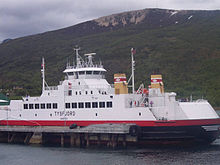
The car ferry connecting Bognes with Lødingen to the north.
Tysfjord is the only location in Norway where the European route E06 highway depends on a car ferry. There are ferry connections from Bognes to Skarberget (route E6) and from Bognes to Lødingen (connecting to route European route E10 and Lofoten). There is also a ferry connecting Drag south of the fjord with Kjøpsvik on the northern shore.
Kjøpsvik is connected to the E6 highway and Narvik by Norwegian National Road 827, with no ferry crossings. This might be an alternative to route E6, and is also the route of choice to get close to Stetind.
If Tysfjord experiences bad weather and the ferry connections are shut down, Norway is cut in two road-wise. A road connection is still maintained, albeit through Sweden, which makes it a very long drive.
The closest airport is Evenes. There is also a small airport in Narvik.
Villages
| Lule Sami | Norwegian |
|---|---|
| Ájládde | Hellandsberg |
| Ájluokta | Drag |
| Gásluokta | Kjøpsvik |
| Hierggenjárgga | Korsnes |
| Jågåsijdda | Storå |
| Måsske | Musken |
| Soahkeluokta | Bjørkvik |
| Stuorgiedde | Storjord |
| Tjierrekluokta | Nordbukt |
| Vuodnabahta | Hellemobotn |
References
^ "Navn på steder og personer: Innbyggjarnamn" (in Norwegian). Språkrådet. Retrieved 2015-12-01..mw-parser-output cite.citation{font-style:inherit}.mw-parser-output q{quotes:"""""""'""'"}.mw-parser-output code.cs1-code{color:inherit;background:inherit;border:inherit;padding:inherit}.mw-parser-output .cs1-lock-free a{background:url("//upload.wikimedia.org/wikipedia/commons/thumb/6/65/Lock-green.svg/9px-Lock-green.svg.png")no-repeat;background-position:right .1em center}.mw-parser-output .cs1-lock-limited a,.mw-parser-output .cs1-lock-registration a{background:url("//upload.wikimedia.org/wikipedia/commons/thumb/d/d6/Lock-gray-alt-2.svg/9px-Lock-gray-alt-2.svg.png")no-repeat;background-position:right .1em center}.mw-parser-output .cs1-lock-subscription a{background:url("//upload.wikimedia.org/wikipedia/commons/thumb/a/aa/Lock-red-alt-2.svg/9px-Lock-red-alt-2.svg.png")no-repeat;background-position:right .1em center}.mw-parser-output .cs1-subscription,.mw-parser-output .cs1-registration{color:#555}.mw-parser-output .cs1-subscription span,.mw-parser-output .cs1-registration span{border-bottom:1px dotted;cursor:help}.mw-parser-output .cs1-hidden-error{display:none;font-size:100%}.mw-parser-output .cs1-visible-error{font-size:100%}.mw-parser-output .cs1-subscription,.mw-parser-output .cs1-registration,.mw-parser-output .cs1-format{font-size:95%}.mw-parser-output .cs1-kern-left,.mw-parser-output .cs1-kern-wl-left{padding-left:0.2em}.mw-parser-output .cs1-kern-right,.mw-parser-output .cs1-kern-wl-right{padding-right:0.2em}
^ "Stadnamn og rettskriving" (in Norwegian). Kartverket. Retrieved 2018-07-13.
^ Statistisk sentralbyrå (2017). "Table: 06913: Population 1 January and population changes during the calendar year (M)" (in Norwegian). Retrieved 2017-09-23.
^ Jukvam, Dag (1999). "Historisk oversikt over endringer i kommune- og fylkesinndelingen" (PDF) (in Norwegian). Statistisk sentralbyrå.
^ Karlsen, Tone Anita (2017-08-22). "Ny Narvik tar form". Harstad Tidende (in Norwegian). Retrieved 2017-09-10.
^ "Intensjonsavtale Hamarøy og Tysfjord" (in Norwegian). Tysfjord kommune. 2016-12-13. Retrieved 2017-09-10.
^ Rygh, Oluf (1905). Norske gaardnavne: Nordlands amt (in Norwegian) (16 ed.). Kristiania, Norge: W. C. Fabritius & sønners bogtrikkeri. p. 275.
^ "Fakta om Tysfjord" (in Norwegian). Tysfjord kommune. Retrieved 2008-11-29.
^ ab [Samiske grenseloser reddet tusenvis. - Så ble de beskyldt for landssvik - Nå får de oppmerksomhet og heder.] [Sami guides saved thousands. - Then they were accused of treason - Now they get attention and are lauded]
^ https://www.independent.co.uk/news/world/europe/norway-rape-children-150-sex-abuse-assault-remote-region-tysfjord-sami-a8085336.html
^ http://www.bbc.co.uk/programmes/w3csvp08
^ Samisk Fadervår for sterk kost for nordmenn [The prayer, Our Father—in Sami—is too upsetting for Norwegians]
^ "Table: 04813: Members of the local councils, by party/electoral list at the Municipal Council election (M)" (in Norwegian). Statistics Norway. 2015.
^ "Norcem - Månedens Bedrift" (in Norwegian). Archived from the original on 2007-09-18. Retrieved 2008-11-29.
^ "Mannfjordbotn naturreservat" (in Norwegian). Archived from the original on 2007-09-26. Retrieved 2008-11-29.
^ "Tysfjord i perioden 1961-1990" (in Norwegian). Archived from the original on 2007-09-29. Retrieved 2008-11-29.
External links
| Wikimedia Commons has media related to Tysfjord. |
 Nordland travel guide from Wikivoyage
Municipal website (in Norwegian)
Municipal fact sheet from Statistics Norway (in Norwegian)
- Unesco-Tysfjord on the tentative list
Summitpost: about Stetind (includes pictures)
About Stetind (includes pictures) (in Norwegian)
- Árran Lule Sami Center
Nordland county, Norway | |||||||||||||||||||||||||||||||||||||
|---|---|---|---|---|---|---|---|---|---|---|---|---|---|---|---|---|---|---|---|---|---|---|---|---|---|---|---|---|---|---|---|---|---|---|---|---|---|
 |
|
 |
|||||||||||||||||||||||||||||||||||
| |||||||||||||||||||||||||||||||||||||


Comments
Post a Comment