 Mixing
Beauport, Quebec City
Beauport | |
|---|---|
Borough of Quebec City | |
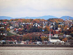 Beauport as seen from Île d'Orléans | |
| Motto(s): "Fide Et Labore Valebo" (Latin) "My worthiness stems from my faith and labour" | |
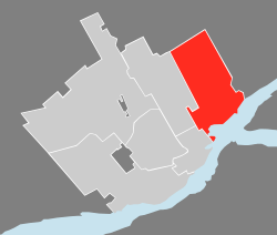 Quebec City with Beauport in red | |
| Country | Canada |
| Province | Quebec |
| Municipality | Quebec City |
| Settled | 17th century |
| Incorporated | 1634 |
| Merged | January 1, 2002 |
| Government | |
| • Type | Borough |
| • Mayor | Régis Labeaume |
| • Councillors | List of Councillors
|
| Area | |
| • Total | 74.37 km2 (28.71 sq mi) |
| Population (2006)[1] | |
| • Total | 74,881 |
| • Density | 1,006.9/km2 (2,608/sq mi) |
| Time zone | UTC-5 (EST) |
| • Summer (DST) | UTC-4 (EDT) |
| Area code(s) | 418 and 581 |
Beauport is a borough of Quebec City, Quebec, Canada on the Saint Lawrence River.
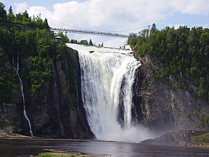
Beauport is a northeastern suburb of Quebec City. Manufacturers include paint, construction materials, printers, and hospital supplies. Food transportation is important to the economy. Attractions include Parc de la Chute-Montmorency (Montmorency Falls Park), which contains a fortification built in 1759 by James Wolfe and Manoir Montmorency, the home from 1791 to 1794 of Prince Edward, Duke of Kent and Strathearn.
The city's historic district contains many interesting churches and homes, including Bélanger-Girardin House, a National Historic Site of Canada where visitors can learn about Beauport's heritage.[1] Annual events include the spring arts festival Salon de Mai and the summer Festival Folklorique des enfants du monde, a multicultural and international children's folklore festival.
Contents
1 History
2 Demographics
3 See also
4 References
History
Beauport was established in 1634, making it one of the oldest European-founded communities in Canada.
An Internment camp was set up at The Armoury in Beauport, Quebec from December 1914 to June 1916.[2]
It was incorporated as a city in 1976 through the amalgamation of seven municipalities (Beauport, Saint-Michel-Archange, Giffard, Villeneuve, Montmorency, Courville and Sainte-Thérèse-de-Lisieux). During the 1990s its population continued to grow because of its economic diversification, available space, and outdoor recreational opportunities. On January 1, 2002, Beauport was merged into Quebec City.
Demographics
According to the Canada 2006 Census:
- Population: 74,881
- % Change (2001-2006): +2.8
- Dwellings: 31,461
- Area (km²): 74.37 km²
- Density (persons per km²): 1,006.8[3]
The Montmorency River and Falls form the eastern boundary of Beauport.
See also
- Charlevoix tourist train
- Municipal reorganization in Quebec
| Wikimedia Commons has media related to Beauport. |
References
^ Bélanger-Girardin House. Canadian Register of Historic Places. Retrieved September 2, 2011.
^ "Internment Camps in Canada during the First and Second World Wars, Library and Archives Canada"..mw-parser-output cite.citation{font-style:inherit}.mw-parser-output q{quotes:"""""""'""'"}.mw-parser-output code.cs1-code{color:inherit;background:inherit;border:inherit;padding:inherit}.mw-parser-output .cs1-lock-free a{background:url("//upload.wikimedia.org/wikipedia/commons/thumb/6/65/Lock-green.svg/9px-Lock-green.svg.png")no-repeat;background-position:right .1em center}.mw-parser-output .cs1-lock-limited a,.mw-parser-output .cs1-lock-registration a{background:url("//upload.wikimedia.org/wikipedia/commons/thumb/d/d6/Lock-gray-alt-2.svg/9px-Lock-gray-alt-2.svg.png")no-repeat;background-position:right .1em center}.mw-parser-output .cs1-lock-subscription a{background:url("//upload.wikimedia.org/wikipedia/commons/thumb/a/aa/Lock-red-alt-2.svg/9px-Lock-red-alt-2.svg.png")no-repeat;background-position:right .1em center}.mw-parser-output .cs1-subscription,.mw-parser-output .cs1-registration{color:#555}.mw-parser-output .cs1-subscription span,.mw-parser-output .cs1-registration span{border-bottom:1px dotted;cursor:help}.mw-parser-output .cs1-hidden-error{display:none;font-size:100%}.mw-parser-output .cs1-visible-error{font-size:100%}.mw-parser-output .cs1-subscription,.mw-parser-output .cs1-registration,.mw-parser-output .cs1-format{font-size:95%}.mw-parser-output .cs1-kern-left,.mw-parser-output .cs1-kern-wl-left{padding-left:0.2em}.mw-parser-output .cs1-kern-right,.mw-parser-output .cs1-kern-wl-right{padding-right:0.2em}
^ Statistics Canada 2006, Community profile.
City of Quebec City | ||
|---|---|---|
| Boroughs |
|
 |
| Districts |
|
|
| Agglomeration |
|
|
| Enclaves |
|
|
| ||
Boroughs and Districts of Quebec City | ||
|---|---|---|
| La Cité-Limoilou |
|
 |
| Les Rivières |
|
|
| Sainte-Foy–Sillery–Cap-Rouge |
|
|
| Charlesbourg |
|
|
| Beauport |
|
|
| La Haute-Saint-Charles |
|
|
Coordinates: 46°51′07″N 71°11′20″W / 46.852°N 71.189°W / 46.852; -71.189


Comments
Post a Comment